

Ready to explore Parc Du Grand-coteau - Pistes Et Sentiers Émilie-mondor? Here's everything you need to know before you go!
Discover the trail


Available trails
| Trails | Distance | Elevation | Duration | Difficulty | GPX |
|---|---|---|---|---|---|
| 1.2 km | 0 m | 16min | Beginner | ||
| 5.5 km | 0 m | 1h30 | Beginner | ||
| 2.5 km | 0 m | 33min | Beginner | ||
| 1 km | 0 m | 15min | Beginner | ||
| 0.5 km | 0 m | 15min | Beginner | ||
| 7 km | 0 m | 1h30 | Intermediate |
Trail description
Description
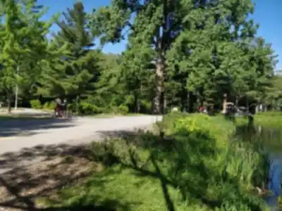
Parc Du Grand-Coteau - Pistes Et Sentiers Émilie-Mondor offers 10 kilometers of well-maintained trails with 50 meters of elevation gain, making it one of the more accessible outdoor destinations in the Lanaudière region. With an estimated hiking time of around 2 hours and 45 minutes for the full network, it hits a sweet spot for people who want a genuine time outdoors without committing to a full-day expedition.
The trail system moves through a varied landscape that keeps the experience interesting from start to finish. You'll pass through open meadow sections where the sky opens up, then duck into stretches of mixed woodland where the canopy closes in and the pace naturally slows. The 50 meters of elevation gain is spread out gradually across the network — there are no punishing climbs here, just enough rolling terrain to give your legs something to work with and reward you with small changes in perspective along the way.
Trail Experience and Terrain
The 10-kilometer network is designed with flexibility in mind. You can tackle the full loop for a solid half-day outing, or stick to shorter segments if you're out with young kids or just want a quick nature break. The trail surface shifts between packed earth in the forested sections and more open ground through the clearings, but the overall condition is well-maintained and navigable for most hikers.
Footing is generally reliable, though wet conditions after rain or during spring snowmelt can make certain sections muddy — standard trail awareness applies. The path is clearly marked throughout, so you can spend your energy taking in the surroundings rather than second-guessing your route. The transitions between forest and open terrain create natural pauses in the hike, good spots to catch your breath, check in with your group, or just stand still for a moment and listen.
The woodland portions have that quality that good forest trails tend to have — soft underfoot, shaded, with the kind of quiet that makes you realize how much background noise you've been tuning out all week. The meadow sections flip that entirely, opening up views of the broader Lanaudière landscape and giving you a different kind of breathing room.
Wildlife and Natural Features
The mix of habitat types — meadow, forest edge, and mature woodland — makes this park a solid spot for wildlife watching. Deer are regularly spotted along the trail, particularly in the early morning and late afternoon when they're most active. The varied environment also supports a healthy bird population, and the contrast between open and forested zones means you're likely to encounter different species depending on which section you're walking through.
Birdwatchers will find the forest-meadow edges especially productive. Bringing binoculars and building in some extra time to stop and observe pays off here. Photographers will appreciate how the light shifts between the shaded canopy and the open clearings — the contrast creates interesting conditions throughout the day, especially in the morning hours.
The forest itself reflects the typical mixed woodland character of the Lanaudière region, with mature trees that change dramatically across the seasons. Spring brings fresh growth and the return of migratory birds. Summer offers full shade and a lush understory. Fall is when the color payoff is highest. Winter transforms the whole network into a quieter, snow-covered version of itself — the trails are suitable for snowshoeing when conditions allow.
Who It's For
This park works well for a wide range of visitors. Families with children will appreciate the manageable terrain and the absence of technical sections. Older hikers or those returning to the trail after a break will find the gradual elevation and clear markings reassuring. Solo hikers looking for a meditative walk in nature will get what they came for in the forested sections. And groups with mixed fitness levels can use the network's flexibility to adjust distance on the fly.
It's also a strong option for people who want to introduce someone new to hiking — the combination of accessible difficulty, varied scenery, and reasonable duration makes for a positive first experience without feeling like a compromise.
Named for Émilie Mondor
The trails carry the name of Émilie Mondor, a Canadian athlete known for her dedication to sport and her connection to the outdoors. Naming the trail network in her honor reflects a broader Quebec tradition of linking natural spaces to the people who've championed athletic life and outdoor recreation. It adds a layer of meaning to the experience — a reminder that these trails exist because communities and individuals have worked to make them happen and keep them accessible.
Practical Notes
Bring water and a snack for the full 10-kilometer loop, even though the difficulty level is easy — staying comfortable on the trail is always worth the small effort of packing well. Proper footwear matters, particularly in the forest sections where roots and uneven ground are part of the terrain. During bug season, insect repellent will make the woodland stretches significantly more enjoyable.
Check trail conditions before heading out, especially in spring when snowmelt can affect certain sections, or following heavy rainfall. As with any natural space, following Leave No Trace principles — packing out your trash, staying on marked trails, and giving wildlife its space — helps keep Parc Du Grand-Coteau - Pistes Et Sentiers Émilie-Mondor in good shape for everyone who comes after you.
Services and amenities
This information may vary by season.
Recommended gear for this trail


Ready to go?
Everything you need to know before you goStarting Point
From Highway 25, take exit 24. Then follow Montée Masson north, then turn left onto Boulevard de Mascouche. The park is then located on the left.
When?
How much?
- Hiking shoes Essential
- → Salomon Elixir Tour Mid WP · 203.38 $
- Layered clothing Essential
- Rain jacket Essential
- Trekking poles
- → Black Diamond Trail Ergo Cork · 69.99 $
- Headlamp
- → Petzl Actik Core 625 · 103.95 $
FAQ - Frequently asked questions
Everything you need to knowThe Essential Hiking Checklist
Everything you need for your next hike. Bilingual, printable, 1 page.
Download the free checklistSimilar hikes nearby
Discover other trails you might enjoy

Mont Sourire
Lanaudière

Parc Régional De La Forêt Ouareau
Lanaudière

Parc Des Chutes Dorwin
Lanaudière

Parc des Cascades
Lanaudière

La Montagne Noire
Lanaudière

Mont Ouareau
Lanaudière
Hiking near Laval
97 trails to explore ~17 km away
We work hard to provide the most up-to-date and error-free data possible. If something seems incorrect, let us know! Your contribution helps the whole community.
Hikers' opinions