

Ready to explore Parc national d'Aiguebelle? Here's everything you need to know before you go!
Discover the trail
Available trails
| Trails | Distance | Elevation | Duration | Difficulty | GPX |
|---|---|---|---|---|---|
| 0.8 km | 15min | Beginner | |||
| 2.2 km | 29min | Beginner | |||
| 1.5 km | 100 m | 29min | Intermediate | ||
| 4 km | 40 m | 57min | Intermediate | ||
| 3 km | 70 m | 46min | Intermediate | ||
| 2 km | 100 m | 36min | Intermediate | ||
| 2 km | 100 m | 36min | Intermediate | ||
| 9.5 km | 70 m | 2h30 | Advanced | ||
| 2.5 km | 100 m | 43min | Advanced | ||
| 11 km | 70 m | 2h30 | Advanced |
Trail description
Description
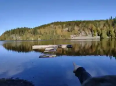
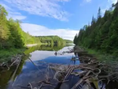
Aiguebelle National Park is best understood through two lenses: history and adventure. The landscape here is built on a 2.7 billion-year-old geological formation shaped by ancient faults and the lakes that formed along them. That deep-time backdrop gives the park a strong natural identity—one that’s a point of pride for the Abitibi-Témiscamingue region.
The park sits in Rouyn-Noranda, right in the middle of the region, on a major watershed divide between Hudson Bay and the ancient Atlantic Ocean. The southern part of the territory is occupied by the Abijévis volcanic hills, which is why so many hikes here feel like you’re moving through a rugged, elevated world rather than a flat boreal forest.
What it’s like on the trails
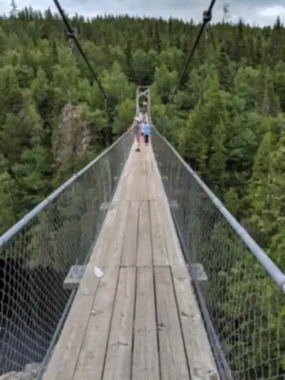
Hiking at Aiguebelle is less about long, steady miles and more about variety—short climbs, sudden viewpoints, and interesting terrain changes that make the park feel “adventurous” even on modest distances. Across the park, you can choose from more than 50 km of trails, ranging from short walks to longer outings. Many have the feel of a real backcountry route: you’ll move through rocky sections and uneven footing, and on certain routes you can find features that add a bit of excitement, like vertiginous escarpments, a suspension bridge, and even a helical staircase.
Geology is the main event here. Along the way you can see rocks described as ancient “aniseed robbing” rocks, plus clear glacial traces and lava flows (“co-eas of lava” in the original description). Even if you’re not a rock person, the scenery tends to pull your attention to the ground under your feet—banded stone, exposed outcrops, and the way the land suddenly drops into a lake basin.
If you want to explore the park from the water, you can also be tempted by a crossing by sea kayak. And if you don’t have all the equipment you need, the park notes that you can rent what you need on-site, which makes it easier to plan a visit without bringing a full kit from home.
Where it is (and a bit of park background)
Aiguebelle is a national park in Quebec. It’s located partly in Mont-Brun and Taschereau, within the Abitibi-Témiscamingue tourist region, and about 50 kilometres from Rouyn-Noranda. The park covers 268.3 km2. It was established in 1985 and went through a boundary review in 1998. Its mission is to protect a representative sample of the Abitibi clay belt and the Abijévis Hills.
Recommended hikes (easy to intermediate)
The hiking network includes trails that are considered easy through to higher, hillier terrain. One well-known easy option is La Castorière (linked in the original content: La Castorière). Easy trails like this are a good match if you’re visiting with newer hikers or you want an outing that leaves time for a picnic or a paddle afterward.
Some trails also offer the option to spend the night in a rustic camp. That’s one of the park’s most distinctive ways to extend the experience: you can hike in, settle into a simple shelter, and turn a short hike into a small overnight adventure without needing a full backcountry setup.
Recommended intermediate option: the Escalade trail
If you want something short but more physical, the recommended intermediate route is the Escalade trail. It’s an out-and-back route of about 1.56 km with 160 m of elevation gain. The distance is short, but the climbing gives it a “quick workout” feel, and the terrain includes steep slopes.
On this hike, you can:
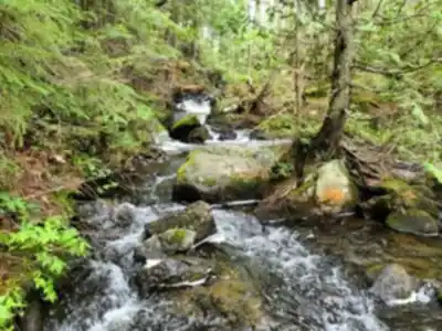
- Climb to the top of La Trompeuse Hill.
- Admire the waterfall on La Haie Creek, known for its clear waters.
- Take in a magnificent view of the hills.
- Spend a memorable night at the rustic camp La Cigale.
Even though it’s described as “not very difficult,” it’s still smart to show up with a good pair of shoes. The steeper pitches can feel slippery or awkward depending on conditions, and solid footwear will make both the climb and the descent more comfortable.
Getting to the trailhead (Escalade)
The starting point for the Escalade trail is in the parking lot at Lac La Haie. It’s easy to reach by car by following Route 26. Because the trail begins right from a parking area, it works well as a half-day plan or as a targeted stop if you’re exploring different sectors of the park.
A bit of snowshoeing
In winter, Aiguebelle turns quiet in a way that’s easy to feel: the squeal of snowshoes biting into the snow and your breath turning the cold air into a fine mist can be the loudest sounds around. Whether you start at Lac La Haie or make your way up to the top of La Trompeuse Hill, the snowy landscape holds tracks and signs of life—your steps weaving among those left by hare, ruffed grouse, and moose crossing through these northern scenes.
There are 40 kilometres of winter routes in total, divided into four marked trails. The experience can scale to your time and energy: a couple of hours for a short loop, or longer days that let you settle into the rhythm of travelling through open, white terrain. If you spot a rustic shelter in the distance, it can be more than just a landmark—it can become your base camp for one or more nights. The park’s winter network supports everything from a quick outing to a longer stay: two hours, two days, two weeks—the idea is to take the time you want in the winter purity of Aiguebelle National Park.
Nearby ideas mentioned
The original content also points to a few nearby or related ideas if you’re planning a broader trip in Abitibi-Témiscamingue, including Chalets du parc national d'Aiguebelle (staying in rustic camps at a modest price), the Lac Loïs sector in summer, La Cité de l'Or in Val-d'Or (including L'Ancienne-Mine-Lamaque interpretation centre), Refuge Pageau (created in 1986 by Michel Pageau and his wife Louise, welcoming wild animals in need of rehabilitation for release), and Opémican National Park (in the MRC de Témiscamingue, bordered by lakes Témiscamingue and Kipawa).
Services and amenities
This information may vary by season.
Recommended gear for this trail


Ready to go?
Everything you need to know before you goStarting Point
To access the hiking trails, you can start at one of the main entrances. The first trailhead is located at 12373 Route d'Aiguebelle, Rouyn-Noranda, QC J0Z 2Y0. Another possible starting point is at 1000 Chemin du Parc-National, Taschereau, QC J0Z 3N0. Both locations have parking facilities available for visitors.
When?
How much?
- Hiking shoes Essential
- → Salomon Elixir Tour Mid WP · 203.38 $
- Layered clothing Essential
- Rain jacket Essential
- Trekking poles
- → Black Diamond Trail Ergo Cork · 69.99 $
- Headlamp
- → Petzl Actik Core 625 · 103.95 $
FAQ - Frequently asked questions
Everything you need to knowThe Essential Hiking Checklist
Everything you need for your next hike. Bilingual, printable, 1 page.
Download the free checklistAlternatives and suggestions
Similar hikes nearby
Discover other trails you might enjoy

Pointe-aux-roches
Abitibi-Témiscamingue

La Bannik
Abitibi-Témiscamingue

Sentiers pédestres Opasatica
Abitibi-Témiscamingue

Récré-eau des quinze
Abitibi-Témiscamingue

Sentier Pédestre Grande Chute
Abitibi-Témiscamingue

Camp Dudemaine
Abitibi-Témiscamingue
Hiking near Gatineau
48 trails to explore ~398 km away
We work hard to provide the most up-to-date and error-free data possible. If something seems incorrect, let us know! Your contribution helps the whole community.
Hikers' opinions