

Ready to explore Mont Du Lac Des Cygnes? Here's everything you need to know before you go!
Discover the trail
Available trails
| Trails | Distance | Elevation | Duration | Difficulty | GPX |
|---|---|---|---|---|---|
| 4.3 km | 480 m | 2h | Advanced |
Trail description
Description
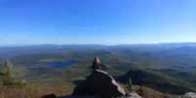
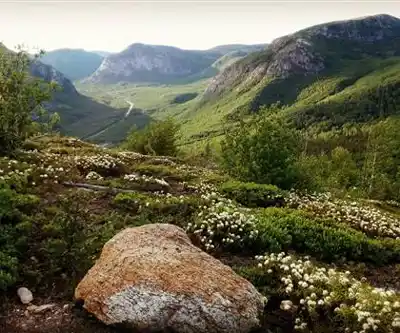
Mont Du Lac Des Cygnes is one of the signature hikes in Québec's Charlevoix region and a core attraction inside Grands-Jardins National Park. It's managed by the Société des établissements de plein air du Québec (SEPAQ), and it's the kind of outing that works well if you want a "real" mountain day without committing to an all-day epic. Hikers come for the summit views and for the feeling of being on top of something geologically dramatic: the peak sits right on the rim of the 56 km diameter Charlevoix Crater, an impact structure formed about 300 million years ago and extending beneath the St. Lawrence River.
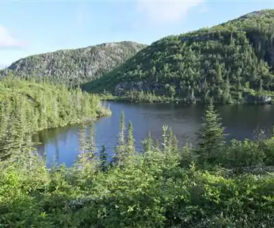
If you like a hike that changes character as you climb—starting in forest, then opening up into more exposed mountain terrain—this one delivers. It's also a place you can return to in different seasons and get a completely different experience each time.
Why this mountain is special in Charlevoix
This summit is tied directly to what makes Charlevoix look and feel different from other regions. The trail climbs within the crater zone, where the landscape was uplifted after a meteorite collision. The crater's center includes the 768 m Mont des Éboulements, and today roughly 90% of Charlevoix's population lives inside the crater. The towns most often mentioned within the crater are La Malbaie and Baie-St-Paul. From the top of Mont Du Lac Des Cygnes, you're standing in a place that helps explain why the region's hills and valleys are laid out the way they are.
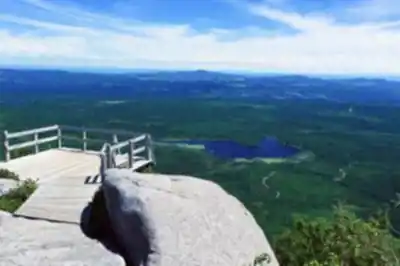
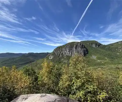
The summit elevation is given as 3215 ft (980 m). While the altitude isn't huge by alpine standards, the setting makes it feel bigger—especially once the trees thin and you start seeing the wider bowl of the crater landscape around you.
Trail stats and what the hike feels like
The main trail covers 4.3 km to the summit with an elevation gain of 480 m. That's enough vertical to give you a solid workout, but it's still reachable for most people who pace themselves and take breaks as needed. Plan on about 2.5 hours for the round trip, though that can stretch longer if you spend time at the summit or move at a more relaxed pace.
Despite being rated as easy, this isn't a flat stroll. You'll be moving through forest and then into more mountain-like ground where footing can feel rougher and more technical in spots. The park has made the final push friendlier by building a long series of stairs for the concluding section to the summit—helpful when you're tired and want a predictable rhythm for that last stretch. Because the climb is continuous, it's a good idea to treat it like a proper hike: bring water, layers, and footwear with grip, and don't be surprised if the descent feels hard on the knees.
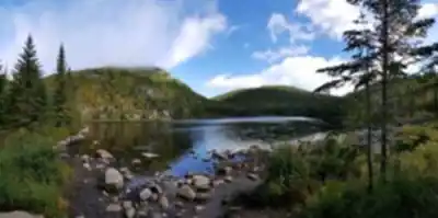
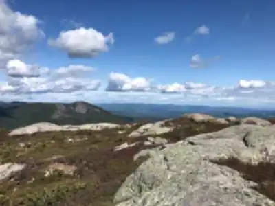
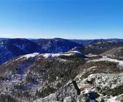
The terrain changes as you gain elevation. You start in mixed forest where the trail can be rooty and occasionally slick, especially after rain. As you climb higher, the forest opens up and you get glimpses of the surrounding crater landscape. The final section with the stairs takes you above treeline where the views really open up and you can see the full scope of the Charlevoix region spread out below.
Beginners may find the difficulty higher than the "easy" rating suggests, especially since this territory is known among experienced hikers. If you're newer to hiking, it's smart to slow down early, watch for slick roots and rocks, and accept that you might slip—this is the kind of trail where careful foot placement matters. The payoff is that, once you're up higher, the mountain air and the quiet of the forest-and-mountain setting can feel calm and soothing compared to busier front-country trails.
Trailhead, parking, and how to get there
The trailhead for Mont Du Lac Des Cygnes is located at the Grands-Jardins central tourist center on Route 381. From Québec City, plan on about 1.5 to 2 hours of driving via Route 138 northeast toward Charlevoix, then up Route 381 to the park. If you're coming from Baie-St-Paul, you're less than a half-hour drive away via Route 381, which is also described as a scenic route.
The drive up Route 381 is part of the experience—you're climbing into the heart of the Charlevoix crater, and the landscape changes noticeably as you gain elevation. The central tourist center has parking and facilities, making it a logical starting point for your day on the mountain.
A practical note for repeat visitors: the main route to the summit was modified in 2009. In other words, maps and trail descriptions from before that update may not match what you see on the ground today—so rely on current park signage and SEPAQ information once you arrive at the central tourist center.
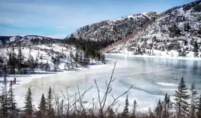
Seasonal options: summer hiking, fall color, and winter snowshoeing
One of the big advantages here is that the trail is stated to be open year-round. In winter, it's considered a great snowshoe hiking location, which makes sense given the steady climb and the built infrastructure near the top. The stairs near the summit are particularly helpful in winter conditions, providing a more secure route when snow and ice make footing tricky.
In summer, it's a classic hiking route where the elevation gain provides natural air conditioning as you climb higher. The forest provides good shade for most of the route, with the final section above treeline offering full sun and views.
For timing, late September or early October is highlighted as an especially good window for climbing. That lines up with cooler temperatures and fall colors in Charlevoix, and it's often the time of year when the climb feels most comfortable and the views are crisp and clear.
Via Ferrata option
In addition to the standard hiking route, the area also offers a Via Ferrata that was installed in 2014. Access is guided, and groups are limited to 8 people or fewer. If you've never tried a Via Ferrata, it's essentially a more technical, equipment-assisted way to move through steeper terrain—so it's a different experience than the main trail and can be a good fit if you want something more adventurous while still being guided.
Other activities and park context
This isn't only a hiking destination: it's also a place people choose for camping and for angling. Even if you're visiting just for the summit hike, it's helpful to know the park attracts a mix of users. That usually means you'll see a steady flow of outdoor enthusiasts at the central tourist center and along access roads—especially during peak summer and fall periods.
The broader Grands-Jardins National Park context means you're in a protected area that showcases the unique ecology of the Charlevoix crater. The park preserves both the geological story of the meteorite impact and the plant and animal communities that have developed in this distinctive landscape over millions of years.
Local geography and crater landmarks
To put your day on the mountain into a broader Charlevoix context, the hike sits near communities that many visitors use as bases. Baie-St-Paul is close (less than half an hour from Route 381), and La Malbaie is another key town in the region. The crater itself extends under the St. Lawrence River, and the uplifted terrain includes Mont des Éboulements (768 m). Knowing this makes the summit feel less like "just a lookout" and more like a window into the geological forces that shaped Charlevoix.
Services and amenities
This information may vary by season.
Recommended gear for this trail


Ready to go?
Everything you need to know before you goStarting Point
Hiking enthusiasts will be pleased with mont du lac des cygnes. This trail is suitable for hiking and is of intermediate difficulty. It is a rich discovery trail with a panoramic view at the top. It starts at the central tourist center of the Parc des Grands-Jardins. You can access it through route 381. The service center is located 21 km from this road. The park entrance fee is $8.90.
To discover another emblematic place of the region, you can go on the trail of L'Acropole-des-Draveurs. Located a 45-minute drive from the Grands-Jardins National Park, this is a top destination for experienced hikers. The level of difficulty of this trail is high. It is therefore not suitable for novices. You should also allow 4 to 6 hours to reach the summit.
When?
How much?
- Hiking shoes Essential
- → Salomon Elixir Tour Mid WP · 203.38 $
- Layered clothing Essential
- Rain jacket Essential
- Trekking poles
- → Black Diamond Trail Ergo Cork · 69.99 $
- Headlamp
- → Petzl Actik Core 625 · 103.95 $
FAQ - Frequently asked questions
Everything you need to knowThe Essential Hiking Checklist
Everything you need for your next hike. Bilingual, printable, 1 page.
Download the free checklistSimilar hikes nearby
Discover other trails you might enjoy

Parc National Des Hautes-gorges-de-la-rivière-malbaie
Charlevoix

Parc National Des Grands-jardins
Charlevoix

Mount Morrios
Charlevoix

Sentiers Pédestres Les Éboulements
Charlevoix

Sentier Des Caps De Charlevoix
Charlevoix

Parc Municipal De La Baie-des-rochers
Charlevoix
Hiking near Quebec City
40 trails to explore ~105 km away
We work hard to provide the most up-to-date and error-free data possible. If something seems incorrect, let us know! Your contribution helps the whole community.
Hikers' opinions