
Our favorite hikes in Charlevoix
Aperçu
Why hike in in Charlevoix?
Our favorites


All trails
22 trails


Featured parks in the region
Must-visit for your hikes in Charlevoix

Parc National des Grands Jardins
National Park
Parc National Des Grands-jardins
National Park
Parc National Des Hautes-gorges-de-la-rivière-malbaie
National ParkWhy hike in in Charlevoix?
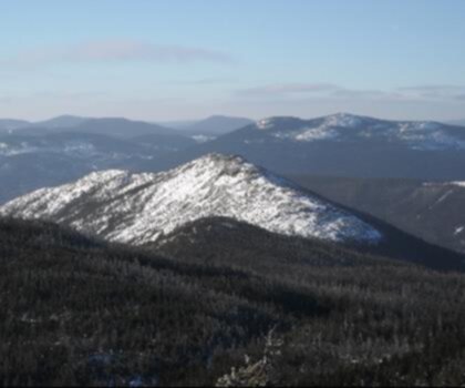
Nestled between the St. Lawrence River and the Canadian Shield, Charlevoix stands as one of Quebec's most spectacular hiking destinations. This UNESCO World Biosphere Reserve offers an extraordinary blend of dramatic landscapes, from ancient crater formations to pristine boreal forests, making it a paradise for outdoor enthusiasts seeking authentic wilderness experiences.
Why Hike in Charlevoix
Charlevoix's unique geography stems from a massive meteorite impact 350 million years ago, creating a distinctive circular landscape that shapes today's hiking terrain. The region showcases dramatic elevation changes, with trails leading through dense mixed forests of maple, birch, and spruce, opening onto breathtaking viewpoints overlooking the St. Lawrence River and its majestic fjord.
The area's rich biodiversity includes black bears, moose, and over 200 bird species, while the changing seasons paint the landscape in vibrant colors. From spring wildflowers carpeting forest floors to autumn's spectacular foliage display, Charlevoix hiking offers year-round natural beauty that captivates photographers and nature lovers alike.
Essential Trails and Outdoor Activities
Beyond traditional hiking, Charlevoix plein air activities encompass a diverse range of adventures. The region's extensive trail network accommodates various outdoor pursuits, including:
- Multi-day backpacking through pristine wilderness areas
- Scenic day hikes to panoramic viewpoints
- Wildlife observation in protected natural habitats
- Photography expeditions capturing dramatic landscapes
- Cross-country skiing during winter months
Difficulty Levels for Every Hiker
Sentiers Charlevoix cater to adventurers of all experience levels. The region features gentle riverside walks perfect for families, moderate forest trails ideal for weekend warriors, and challenging mountain ascents that test experienced hikers' endurance. This diversity ensures that whether you're introducing children to hiking or seeking your next summit challenge, Charlevoix delivers memorable outdoor experiences.
Seasonal Considerations
The optimal hiking season extends from May through October, with each period offering distinct advantages. Late spring brings rushing waterfalls and emerging wildlife, while summer provides warm weather and full trail accessibility. Fall transforms the landscape into a spectacular color palette, though weather can be unpredictable.
Practical Hiking Tips
Successful Charlevoix adventures require proper preparation. Essential gear includes sturdy hiking boots for varied terrain, layered clothing for changing weather conditions, and bear-safe food storage. Many trailheads offer parking facilities, though popular destinations fill quickly during peak seasons.
Weather in this region can change rapidly, particularly at higher elevations, so checking current conditions before departure is crucial. Trail maps and GPS devices are recommended, as some remote areas have limited cell coverage. Local outfitters provide equipment rentals and guided services for those seeking expert knowledge of the region's hidden gems.
Whether you're planning a challenging multi-day expedition or a leisurely afternoon walk, Charlevoix's remarkable landscapes and well-maintained trail system promise unforgettable outdoor adventures in one of Canada's most beautiful natural settings.
What hikers say
"Nous avons organisé une escapade romantique à Charlevoix et c'était magique. Les sentiers sont non seulement beaux mais aussi paisibles, offrant des moments de calme à deux. La nature est préservée et nous avons pu profiter de magnifiques paysages. Une belle expérience à renouveler!"
"En tant que photographe, Charlevoix m'a vraiment séduit. Les paysages changent avec les saisons et offrent des opportunités de prises de vue extraordinaires. J'ai pu capturer des couchers de soleil époustouflants. Les sentiers sont bien entretenus et permettent d'accéder à des points de vue incroyables. Une région à visiter absolument!"
"Charlevoix has undoubtedly become my favorite hiking destination! The diversity of trails is astonishing, from leisurely walks perfect for families to challenging hikes that thrill experienced adventurers. The views overlooking the St. Lawrence River are simply breathtaking, especially during sunset. A must-visit for anyone who loves nature!"
"Charlevoix est un véritable paradis pour les randonneurs. J'ai particulièrement apprécié les sentiers offrant des vues spectaculaires sur le fleuve Saint-Laurent. La biodiversité est incroyable et les rencontres avec la faune sont fréquentes. Je recommande vivement cette région aux amateurs de nature!"
The Essential Hiking Checklist
Everything you need for your next hike. Bilingual, printable, 1 page.
Download the free checklistExplore other regions
Discover hikes in neighboring regions


Explore by starting city
Find trails near your cityFrequently Asked Questions
Quickly find answers to your questions