

Ready to explore Parc Municipal De La Baie-des-rochers? Here's everything you need to know before you go!
Discover the trail


Trail description
Description
Parc Municipal De La Baie-des-Rochers is a quiet, lesser-known place to get outside in the Charlevoix region, set right along the St. Lawrence River. It’s the kind of park that works whether you’re arriving with hiking boots and a full day plan, or you just want an unhurried walk with big views and plenty of time to look around.
What stands out here is how quickly the scenery shifts. One moment you’re in lush forest, the next you’re stepping into openings where the river dominates the view. The park’s name fits: tranquil bays and rocky shorelines are part of the experience, and they give you those classic Charlevoix-feeling viewpoints without needing an extreme itinerary.
Setting and scenery along the St. Lawrence
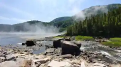
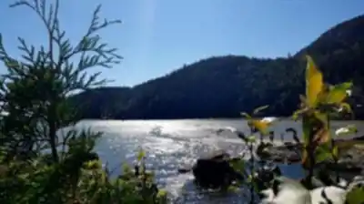
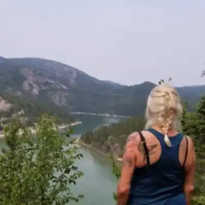
The park sits on the edge of the St. Lawrence, and the river is a constant presence—through wide-open vistas, through the soundscape, and through the wildlife it attracts. Expect a mix of dense woodland sections and more exposed viewpoints where you can take in the river and the surrounding mountains. These lookouts are the natural “pause points” on the walk, where most people slow down, take photos, and scan the water.
Because the landscape includes bays, shoreline rocks, and forest, you get a variety of textures underfoot and around you. The wooded stretches feel sheltered and calm, while the open sections feel bigger and more expansive, especially when the light changes over the river.
Hiking options and trail feel
Parc Municipal De La Baie-des-Rochers offers multiple hiking trails designed for different skill levels, so it can work for a leisurely outing or a more challenging hike depending on what you choose. One of the most popular routes is the Sentier de la Baie-des-Rochers, which leads you through the park’s signature mix of forest and viewpoints.
If you’re here primarily to hike, plan on a route that weaves through dense woodlands and then opens onto panoramic vistas of the St. Lawrence River and the surrounding mountains. The transitions are part of the fun: you’ll move from enclosed, green forest corridors into brighter clearings where the landscape stretches out in front of you.
For visitors looking for a straightforward outing, the park is also well-suited to an easy-paced walk where the focus is on the scenery rather than pushing mileage. If you’re visiting with a group where everyone has different comfort levels, the variety of trails makes it easier to choose something that matches the day’s energy.
- Trail name: Parc Municipal De La Baie-des-rochers
- Region: Charlevoix
- Distance: 7 km
- Elevation gain: 200 m
- Difficulty: Easy
Terrain, viewpoints, and what you’ll experience
On the ground, the experience is a blend of forest walking and viewpoint breaks. The wooded sections feel lush and immersive—good places to slow down and notice smaller details like changes in vegetation and the quiet, sheltered feel of the trees. Then, when the trail opens up, you get those broad Charlevoix panoramas: the St. Lawrence in the foreground and mountains beyond.
The bays add a different kind of calm compared to more open stretches of shoreline. They’re the spots where the water often looks smoother and where you’ll want to linger—whether that’s to watch for wildlife, take photos, or just enjoy the stillness. The rocky edges near the water are also where the park’s character really shows up, especially when you’re scanning the shoreline for movement.
Wildlife watching and nature photography
The park is known for its rich biodiversity and for protecting its natural beauty, which is part of why it feels so peaceful. If you like birdwatching or carrying a camera, this is a place where it pays to move slowly and look up as well as out across the water.
Keep an eye out for bald eagles soaring overhead, especially when you’re near the open viewpoints along the river. Down near the water’s edge, you may also spot seals basking on the rocks. The combination of forest habitat and shoreline makes wildlife sightings feel like a natural part of the visit rather than something you have to chase.
Other things to do in the park
Hiking may be the main draw, but it’s not the only way to enjoy Parc Municipal De La Baie-des-Rochers. The calm waters of the bay make it a nice place to spend time on the water as well. If you’re bringing a kayak, you can get a different perspective on the shoreline and the surrounding landscape by paddling in the sheltered bay.
There are also designated picnic areas, which fit the park’s relaxed pace. A picnic here feels less like an add-on and more like part of the outing—especially if you plan your meal break around a scenic spot and give yourself time to sit and watch the river.
Interpretive panels and learning as you go
Along some of the trails you’ll find interpretive panels that share information about the area’s ecology and history. They’re easy to work into a hike without turning it into a “stop every five minutes” experience—more like optional moments to add context to what you’re already seeing in the forest and along the shoreline.
How to plan a comfortable visit
This park works well for both an active outing and a slower day outdoors. If you’re coming to hike, give yourself enough time to pause at viewpoints, scan for wildlife, and enjoy the bays rather than treating the trails like a checklist. If you’re coming more for the atmosphere, you can keep things simple: a walk, a few scenic stops, and time at a picnic area or by the water.
Bring what you’d normally pack for a riverfront hike—something to drink, a camera if you like photography, and whatever you need to be comfortable moving between shaded forest and more open viewpoints. The scenery here rewards people who take their time and look closely, especially when the light over the St. Lawrence changes and the views shift from one viewpoint to the next.
Recommended gear for this trail


Ready to go?
Everything you need to know before you goStarting Point
To access the hiking trails, head to the main trailhead located at 1050 Chemin de la Baie-des-Rochers, Saint-Siméon, QC G0T 1X0. This is the primary starting point for exploring the area. There are no additional trailheads for this location.
When?
How much?
- Hiking shoes Essential
- → Salomon Elixir Tour Mid WP · 203.38 $
- Layered clothing Essential
- Rain jacket Essential
- Trekking poles
- → Black Diamond Trail Ergo Cork · 69.99 $
- Headlamp
- → Petzl Actik Core 625 · 103.95 $
FAQ - Frequently asked questions
Everything you need to knowThe Essential Hiking Checklist
Everything you need for your next hike. Bilingual, printable, 1 page.
Download the free checklistSimilar hikes nearby
Discover other trails you might enjoy

Mont Du Lac Des Cygnes
Charlevoix

Parc National Des Hautes-gorges-de-la-rivière-malbaie
Charlevoix

Parc National Des Grands-jardins
Charlevoix

Mount Morrios
Charlevoix

Sentiers Pédestres Les Éboulements
Charlevoix

Sentier Des Caps De Charlevoix
Charlevoix
Hiking near Quebec City
40 trails to explore ~165 km away
We work hard to provide the most up-to-date and error-free data possible. If something seems incorrect, let us know! Your contribution helps the whole community.
Hikers' opinions