

Ready to explore Scarborough Bluffs Trail? Here's everything you need to know before you go!
Discover the trail


Available trails
| Trails | Distance | Elevation | Duration | Difficulty | GPX |
|---|---|---|---|---|---|
| 5 km | 0 m | 1h | Beginner |
Trail description
Description
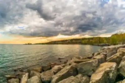
The Scarborough Bluffs Trail delivers one of the most dramatic lakefront hiking experiences in the Greater Toronto Area. Running 3.2 kilometers along the edge of towering clay and limestone cliffs that rise up to 90 meters above Lake Ontario, this trail offers a landscape that feels genuinely wild despite sitting well within city limits. The geological formations here are unlike anything else in southern Ontario — thousands of years of erosion and sediment layering have produced striking white and tan cliff faces that contrast sharply with the deep blue water below.
At an easy difficulty rating with 85 meters of elevation change and an estimated 1 hour 15 minutes to complete, this trail is accessible to most hikers, including families with older kids and anyone looking for a rewarding outing without committing to a full-day effort. The elevation gain isn't concentrated in one brutal climb — it's spread across several shorter descents and ascents as the trail moves between the cliff tops and the shoreline.
What to Expect on the Trail
The trail surface shifts noticeably as you move through different sections. Forested stretches run on packed earth and are generally smooth underfoot. As you approach the bluff edges and viewpoints, the ground becomes more uneven, with exposed roots and occasional rocky patches. Near the beach access points, the path transitions to sand, which slows your pace a bit but signals that you're about to get a completely different perspective on the landscape.
The cliff-top sections are the visual highlight. From several open viewpoints along the route, you're looking out across Lake Ontario toward the Toronto Islands and the downtown skyline. On a clear day, the horizon stretches far enough that the water and sky seem to blur together. The cliff faces themselves are worth stopping to study — the distinct geological layers are clearly visible, and you can see where ongoing erosion continues to reshape the bluffs. It's a slow-motion process, but the evidence is everywhere.
The forested sections provide a different kind of appeal. The mixed woodland canopy creates shade and a quieter atmosphere, and the habitat variety — forest, cliff edge, and shoreline all within a short stretch — makes this a genuinely productive spot for birdwatching. Woodland species and waterfowl both show up here, and the transition zones between habitat types tend to be the most active areas.
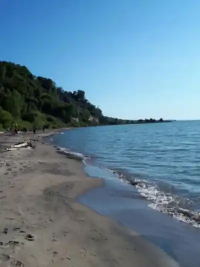
Bluffers Park Beach
Bluffers Park Beach sits at the base of the bluffs and serves as a natural midpoint or turnaround destination for many hikers. Getting down to the beach level changes everything about how you perceive the cliffs — looking up at those towering formations from the shoreline is a noticeably different experience than looking out from the top. The scale becomes much more apparent from below.
The beach itself is sandy and spacious enough to spread out, making it a practical spot for a longer break. Many hikers time their visit to include lunch here. You can wade into the lake during warmer months, and the combination of cliff views and open water makes it one of the better picnic spots in the GTA. It's worth factoring this stop into your timing rather than rushing through.
Planning Your Visit
Footwear matters on this trail. The mix of packed earth, sandy sections, and uneven ground near the bluff edges calls for shoes with solid traction and reasonable ankle support. Trail runners or hiking boots both work well. Sandals or flat sneakers will feel limiting, especially on the steeper descent sections.
Bring water, particularly in summer. The exposed cliff-top viewpoints offer little shade, and the beach section can feel warm on sunny days. The forested stretches provide relief, but the open sections are genuinely exposed to sun and wind.
Timing your visit makes a real difference. Weekends and warm-weather holidays bring significant crowds to both the trail and Bluffers Park Beach. Parking at Bluffers Park fills up quickly during peak periods, and the trail itself can feel congested. Weekday mornings offer a noticeably more peaceful experience — better for wildlife observation, photography, and simply enjoying the views without navigating around other groups. If you're driving, arriving early is the most reliable way to secure parking. Public transit access is available, though it requires some advance route planning.
Safety and Environmental Considerations
The cliff edges require consistent awareness. Barriers exist in some areas, but sections of the trail bring you close to significant drop-offs with no fencing. Stay on the designated path — this protects both you and the bluffs themselves, which are actively eroding. Getting too close to the edge isn't just a personal risk; foot traffic near the cliff tops accelerates erosion and degrades the trail for everyone who comes after.
After rain, some sections become slippery, particularly the steeper descents toward the water. Wind along the exposed cliff tops can be stronger than expected, especially in spring and fall. Dressing in layers and checking conditions before you head out is worth the extra minute.
The Scarborough Bluffs Trail sits in an unusual position — it's a genuinely striking natural landscape that happens to be easily reachable from one of Canada's largest cities. That accessibility is part of what makes it special, and it's also why staying on marked trails and packing out your trash matters here more than in more remote locations. The trail holds up well under heavy use when visitors treat it accordingly.
Services and amenities
This information may vary by season.
Recommended gear for this trail


Ready to go?
Everything you need to know before you goStarting Point
There are several routes to start your hiking at the bluffs trail Ontario, Toronto, but bluff’s park trail / Bluffers park trail is widely used. The trail is flat with an intensity of 1/5 track that leads from beach bluffer park and the Lakeshore to Bluffs park. You can found the Scarborough bluffs map here.
The route is almost flat, with not many hurdles that you can follow for jogging or hiking to improve the intensity. You may not find it more challenging, but it offers many opportunities to enjoy natural scenes and the best photo shot experience.
When?
How much?
- Hiking shoes Essential
- → Salomon Elixir Tour Mid WP · 203.38 $
- Layered clothing Essential
- Rain jacket Essential
- Trekking poles
- → Black Diamond Trail Ergo Cork · 69.99 $
- Headlamp
- → Petzl Actik Core 625 · 103.95 $
FAQ - Frequently asked questions
Everything you need to knowThe Essential Hiking Checklist
Everything you need for your next hike. Bilingual, printable, 1 page.
Download the free checklistSimilar hikes nearby
Discover other trails you might enjoy

Trillium Park
Greater Toronto Area
Balmy Beach Park
Greater Toronto Area
High Park
Greater Toronto Area
Colonel Samuel Smith Park
Greater Toronto Area
Mimico Waterfront Park
Greater Toronto Area
Etobicoke Valley Park
Greater Toronto Area
Hiking near Toronto
168 trails to explore ~13 km away
We work hard to provide the most up-to-date and error-free data possible. If something seems incorrect, let us know! Your contribution helps the whole community.
Hikers' opinions