

Ready to explore Parc national des Hautes-Gorges-de-la-Rivière-Malbaie? Here's everything you need to know before you go!
Discover the trail
Available trails
| Trails | Distance | Elevation | Duration | Difficulty | GPX |
|---|---|---|---|---|---|
| 2.5 km | 35 m | 37min | Beginner | ||
| 0.5 km | 78 m | 15min | Beginner | ||
| 0.4 km | 55 m | 15min | Beginner | ||
| 0.5 km | 60 m | 15min | Beginner | ||
| 4.28 km | 470 m | 2h | Intermediate | GPX | |
| 7.6 km | 20 m | 2h | Intermediate | ||
| 5.39 km | 1486 m | 3h30 | Advanced | GPX |
Trail description
Description
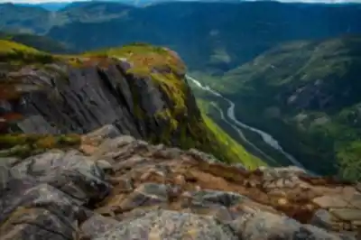
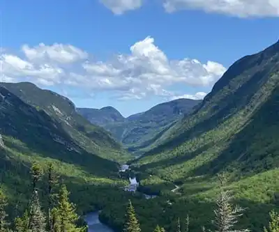
Parc national des hautes-gorges-de-la-rivière-malbaie sits in the heart of the Charlevoix region and is known for big, dramatic scenery: steep, towering cliffs rising above a deep valley, dense forest on the slopes, and the calm Malbaie River winding along the bottom. Even before you set foot on a trail, the park feels vertical—walls of rock and long views down the river corridor are a constant backdrop.
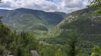
On a visit here, expect a mix of forest walking, open viewpoints, and stretches where you’re moving through a landscape shaped by rock, water, and elevation. The park’s appeal is how quickly it shifts from sheltered riverside to high, exposed lookouts—one moment you’re close to the water and the next you’re looking out over the Charlevoix terrain from above the treetops.
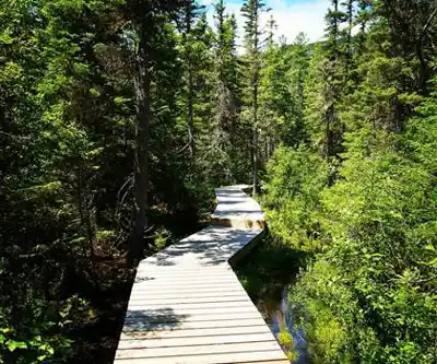
Hiking trails and what they feel like
The park offers a variety of hiking trails that work for different experience levels, from easy walks to demanding climbs. If you’re planning your day around a signature challenge, the Acropole des Draveurs trail is the one people come for. It’s described as a must-try for those seeking a challenge, and it delivers that “earn-your-view” experience with panoramic scenery from one of the highest peaks in the region. This is the kind of hike where you’ll want to pace yourself early, settle into a steady rhythm on the climb, and leave time to enjoy the views once you reach the top rather than rushing back down.
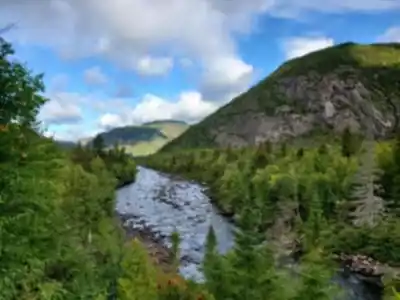
For a calmer outing, Le Riverain trail is the easy option and follows along the riverbank. The experience here is about staying close to the Malbaie River and letting the valley do the talking—water beside you, forest around you, and frequent chances to pause without the pressure of a big ascent. It’s also a good choice if you want a shorter, lower-effort walk that still feels immersive, or if you’re visiting with a mixed group where not everyone wants a steep climb.
Whichever route you choose, the park’s landscapes tend to make the hike feel “bigger” than the mileage alone: cliffs draw your eyes upward, the river pulls you forward through the valley, and the forest keeps the atmosphere cool and shaded in many sections. Plan for a day where the scenery is constantly changing, especially if you combine a riverside walk with time spent at viewpoints.
Signature terrain: cliffs, forest, and the Malbaie River
What sets parc national des hautes-gorges-de-la-rivière-malbaie apart in Charlevoix is the contrast between the vertical rock walls and the quiet river valley. The cliffs are a defining feature—towering, dramatic, and impossible to ignore. They create a sense of scale that makes even simple moments (like stopping for a drink of water or listening to the wind in the trees) feel more memorable because of what’s rising around you.
The forests here add another layer to the experience. On trail, you’ll move through lush greenery that softens the rugged edges of the park’s rock. In places, you’ll feel tucked in and protected; in others, the terrain opens up and the wider valley becomes the focus again. The Malbaie River, meanwhile, isn’t just a scenic extra—it’s the thread that ties the park together, guiding the valley’s shape and giving you a constant sense of direction as it winds through the landscape.
Wildlife and what to watch for
The park’s diverse ecosystems support a mix of animals you genuinely have a chance of spotting if you move quietly and stay alert. Keep your eyes open for moose and beavers, especially near calmer waters and along the river corridor where wildlife activity is often easier to notice. Overhead, it’s also possible to see peregrine falcons—look up near cliff faces where soaring birds stand out against the sky.
Wildlife viewing here rewards patience more than luck. Slow down in quieter sections, scan the river edges, and listen for movement in the brush. If you’re hiking in a group, occasional silent stretches can make a big difference in what you notice. Bringing binoculars can be helpful for watching birds above the cliffs or checking distant movement across the valley without disturbing anything.
Seasonal feel and winter options
The park changes character dramatically with the seasons. In autumn, the forest turns into a showcase of vibrant foliage, making even familiar trail sections feel new. When winter arrives, the same landscapes become snow-covered and the park shifts into a colder, quieter version of itself—ideal for winter activities like snowshoeing and cross-country skiing. Those winter outings offer a different kind of payoff: less crowd energy, a more hushed atmosphere, and a strong sense of the valley’s shape under a blanket of snow.
In shoulder seasons, be ready for varied conditions as the park transitions between warm and cold. The cliffs, river, and forest remain the constants, but the experience changes depending on footing and visibility. If you’re visiting in winter, treat your outing as a true winter trip—dress for changing weather, give yourself extra time, and plan breaks so you can stay warm while still enjoying the views.
Beyond hiking: river time, picnics, and learning opportunities
If you want to build a fuller day in the park, there are good options beyond just walking trails. Visitors can enjoy canoeing on the Malbaie River, which gives you a low-angle perspective on the valley and cliffs—an entirely different feel than looking down from a peak. Being on the water also slows the pace naturally, which can make wildlife spotting along the banks more likely.
There are also scenic picnic spots where you can take a proper break rather than eating on the go. A picnic here isn’t just a quick lunch; it’s a chance to settle in and appreciate the setting—forest shade, river sounds, and the looming presence of the cliffs.
For visitors who enjoy learning while they explore, the park offers guided tours and educational programs focused on the area’s natural history. These can be a strong addition if you want more context about what you’re seeing—why the valley looks the way it does, how the ecosystems fit together, and what makes this corner of Charlevoix distinctive.
Planning your visit: choosing your day
This park works well for both a day trip and a longer stay because you can scale your outing to your energy level. If you’re aiming for a big hiking goal, plan your day around the Acropole des Draveurs trail and give yourself time for breaks and viewpoints. If you want something simpler or more relaxed, Le Riverain lets you spend time near the Malbaie River without committing to a major climb, while still keeping you fully in the park’s signature scenery.
A good approach is to think about what you want most: wide, panoramic views from high ground; a quieter riverside walk with steady scenery; time on the water; or a mix of all of it. The park’s layout and variety make it easy to tailor the experience, but the key is to choose the pace that matches your group and the season you’re visiting.
Services and amenities
This information may vary by season.
Recommended gear for this trail


Ready to go?
Everything you need to know before you goStarting Point
To access the hiking trails, head to the main entrance of the park. The primary trailhead is located at 25 Rang Saint-Louis, Notre-Dame-des-Monts, Quebec G0A 1K0. There are several parking lots available near this entrance. From there, you can find signs directing you to various trailheads within the park.
When?
How much?
- Hiking shoes Essential
- → Salomon Elixir Tour Mid WP · 203.38 $
- Layered clothing Essential
- Rain jacket Essential
- Trekking poles
- → Black Diamond Trail Ergo Cork · 69.99 $
- Headlamp
- → Petzl Actik Core 625 · 103.95 $
FAQ - Frequently asked questions
Everything you need to knowThe Essential Hiking Checklist
Everything you need for your next hike. Bilingual, printable, 1 page.
Download the free checklistSimilar hikes nearby
Discover other trails you might enjoy

Mont Du Lac Des Cygnes
Charlevoix

Parc National Des Grands-jardins
Charlevoix

Mount Morrios
Charlevoix

Sentiers Pédestres Les Éboulements
Charlevoix

Sentier Des Caps De Charlevoix
Charlevoix

Mont du Dôme
Charlevoix
Hiking near Quebec City
40 trails to explore ~130 km away
We work hard to provide the most up-to-date and error-free data possible. If something seems incorrect, let us know! Your contribution helps the whole community.
Hikers' opinions