

Ready to explore Sentier Des Caps De Charlevoix? Here's everything you need to know before you go!
Discover the trail
Available trails
| Trails | Distance | Elevation | Duration | Difficulty | GPX |
|---|---|---|---|---|---|
| 3 km | 40min | Beginner | |||
| 2.2 km | 29min | Beginner | |||
| 6.3 km | 1h30 | Intermediate | |||
| 3 km | 40min | Intermediate | |||
| 6.4 km | 1h30 | Intermediate | |||
| 49.5 km | 750 m | 12h | Intermediate | ||
| 3.2 km | 43min | Intermediate | |||
| 5.3 km | 200 m | 1h30 | Intermediate | ||
| 5.2 km | 450 m | 2h | Advanced | ||
| 4.6 km | 250 m | 1h30 | Advanced |
Trail description
Description
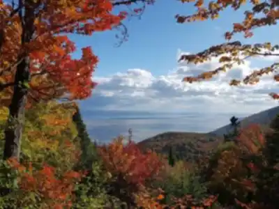
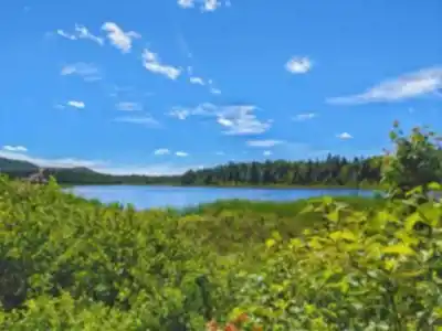
Sentier des Caps de Charlevoix is a multi-season trail network that winds through the mountains of Quebec’s Charlevoix region. Whether you show up for hiking, snowshoeing, or cross-country skiing, the experience is all about moving through forested terrain and popping out to big viewpoints over the St. Lawrence River and the Charlevoix capes. The overall feel is quiet and “away from it all,” but it’s still easy to access from nearby towns like La Malbaie, which makes it a practical option for a day outdoors as well as a longer adventure.
This is also a place that works for a wide range of people. The trails are described as not very difficult and suitable for beginners and experienced sportsmen and women alike, and it’s presented as a good option if you want a family hike or simply a nature-focused outing with friends. The roads/trails are said to be not too difficult, and the level of “fall” (steep drop/off-camber challenge) is less than many other places—so it’s an approachable way to get into Charlevoix terrain without feeling constantly on edge.
What the trail is like
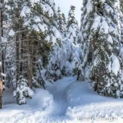
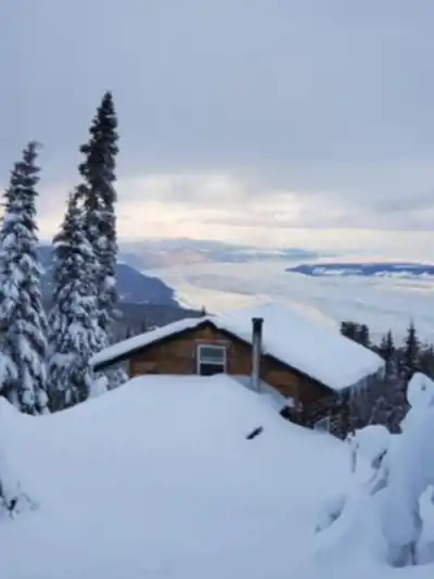
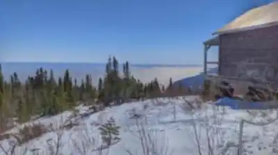
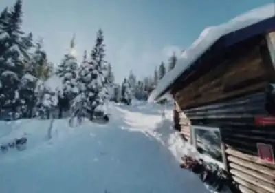
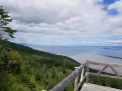
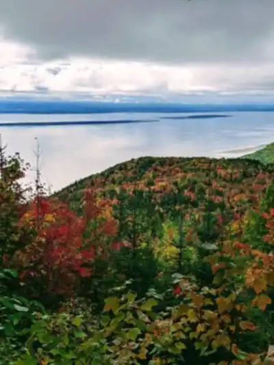
The trail runs through Charlevoix’s mountainous landscape, with a mix of forest travel and viewpoint moments. You’ll spend time under a canopy of trees, then climb or traverse to open lookouts where the St. Lawrence River becomes the main feature in the distance. The capes themselves are the signature scenery here: bold landforms that shape the horizon and make even a short outing feel scenic.
In summer, the area is described as especially colourful and fragrant, with the trails turning into a “sonata of seductive color and tempting scent.” Practically speaking, expect classic warm-season hiking conditions: forest shade, changing light, and long stretches where you can settle into a steady pace. Viewpoints are a highlight, and the setting also puts you in a great position to look out toward places like Isle-aux-Coudres and the archipelago of Montmagny Island.
Key locations and highlights along the way
If you’re planning your visit around specific landmark stops, several focal points are called out:
- Cap Tourmente National Wildlife Area
- St. Anne River Canyon
- Seven Chutes Park
These names give you a good sense of what the route connects: protected natural areas, a canyon feature, and a park known for “chutes” (waterfalls/rapids). Even if you’re not doing a full end-to-end trip, they’re useful anchors for planning which sector to visit and what kind of scenery you’ll get on your hike or ski.
Distances and route options (day trips and longer hikes)
There are multiple ways to experience the Sentier des Caps de Charlevoix, from short outings to multi-day treks:
- The broader trail length is described as approximately 38.4 km, starting in Saint-Tite-des-Caps and ending in Riviere-Saint-Francois.
- For long hikes, one option mentioned is 28 km of trails in St-Tite-des-Caps.
- You can also choose a long hike from 2 to 6 days, with the option to sleep in a campground or a rustic cabin.
For planning purposes, that flexibility is a big advantage: you can treat the area like a network where you pick a loop or segment for a day, or commit to a longer point-to-point experience with overnight stops. The multi-day format is also supported by a practical service: the trail company offers transportation of your luggage with your vehicle, which can make a 2–6 day itinerary feel more manageable if you don’t want a fully loaded pack the whole way.
Winter: snowshoeing and cross-country skiing
Winter is a major season here, with a lot of variety depending on how far you want to go and what gear you prefer.
For snowshoeing, there are seven trails ranging from 4 km to 12.8 km total. These snowshoe routes are described as leading you to Saint-Laurent, giving you a clear direction/goal for route planning.
For cross-country skiing, the Summit Massif sector has 27 km of trails. In addition, the snowshoeing trails are also referenced as 8 km in another winter-distance note, which suggests you’ll see different totals depending on which segment or grouping you choose.
A newer option has also been added: a brand new 8.3 km skate ski trail, reserved for skate-ski admirers of the sport. If skate skiing is your priority, that dedicated trail is worth targeting when you choose where to start your day.
Because cross-country skiing is popular here, it’s divided into 3 sectors with age-based categories mentioned: from 26 years old and up, couple from 26 years old and up, and from 14 to 22 years old. When you’re planning a winter visit, keep those divisions in mind as part of how the ski offering is organized on-site.
Summer and shoulder seasons
Although winter gets a lot of attention, the summer experience is specifically called out as a reason to visit too. The area shifts from snow-season routes into a warm-season forest itinerary, where colour and scent become part of the appeal. Hiking in these months is about steady movement through the woods and climbing into viewpoints that open onto the St. Lawrence River and the capes.
The location also stands out because the trail viewpoints connect your hike to a wider sense of place in Charlevoix: on clear days, you’re looking toward recognizable features like Isle-aux-Coudres and the archipelago of Montmagny Island. That helps even a simple day hike feel like a tour of the region’s geography rather than just a walk in the woods.
Access and who it’s best for
The trail is described as easily accessible from La Malbaie, which is helpful if you’re staying in town and want a straightforward drive-to-trail experience. It’s also positioned as a great place for a family hike. Because the activities are said to be not very difficult, it works well for mixed groups where some people want a challenge and others mainly want scenery and a comfortable pace.
If your goal is to rediscover outdoor activities or try a new forest itinerary, this network gives you options across seasons without having to commit to technical terrain. The combination of approachable trails, strong viewpoints, and the ability to scale your outing from a short loop to a 2–6 day trip is what makes the Sentier des Caps de Charlevoix stand out within the Charlevoix region.
The overall vibe is described as magical and quiet, and it’s rated 4 stars out of 5.
Services and amenities
This information may vary by season.
Recommended gear for this trail


Ready to go?
Everything you need to know before you goStarting Point
The trailhead for the sentier des caps de charlevoix is located at the entrance to the village of Saint-Siméon, on Route 138.
When?
Tuesday: 8:30 AM – 4:00 PM
Wednesday: 8:30 AM – 4:00 PM
Thursday: 8:30 AM – 4:00 PM
Friday: 8:30 AM – 4:00 PM
Saturday: 8:30 AM – 4:00 PM
Sunday: 8:30 AM – 4:00 PM
How much?
- Hiking shoes Essential
- → Salomon Elixir Tour Mid WP · 203.38 $
- Layered clothing Essential
- Rain jacket Essential
- Trekking poles
- → Black Diamond Trail Ergo Cork · 69.99 $
- Headlamp
- → Petzl Actik Core 625 · 103.95 $
FAQ - Frequently asked questions
Everything you need to knowTuesday: 8:30 AM – 4:00 PM
Wednesday: 8:30 AM – 4:00 PM
Thursday: 8:30 AM – 4:00 PM
Friday: 8:30 AM – 4:00 PM
Saturday: 8:30 AM – 4:00 PM
Sunday: 8:30 AM – 4:00 PM
The Essential Hiking Checklist
Everything you need for your next hike. Bilingual, printable, 1 page.
Download the free checklistAlternatives and suggestions
Similar hikes nearby
Discover other trails you might enjoy

Mont Du Lac Des Cygnes
Charlevoix

Parc National Des Hautes-gorges-de-la-rivière-malbaie
Charlevoix

Parc National Des Grands-jardins
Charlevoix

Mount Morrios
Charlevoix

Sentiers Pédestres Les Éboulements
Charlevoix

Mont du Dôme
Charlevoix
Hiking near Quebec City
40 trails to explore ~68 km away
We work hard to provide the most up-to-date and error-free data possible. If something seems incorrect, let us know! Your contribution helps the whole community.
Hikers' opinions