

Ready to explore Mont Grand-Fonds? Here's everything you need to know before you go!
Discover the trail
Trail description
Description
Mont Grand-Fonds is one of those hiking spots in Charlevoix that doesn't get as much attention as it deserves. It's close to La Malbaie, easy to reach, and delivers the kind of mountain experience that feels genuinely earned — forested climbs, shifting terrain, and viewpoints that open up over the surrounding hills and valleys. At 4.2 km with 335 m of elevation gain, it's a moderate outing that takes most hikers around two and a half hours to complete.
What kind of hike this is
The route at Mont Grand-Fonds is classified as moderate, and that rating fits. The 335 m of elevation gain is real — you'll feel it in your legs, especially on the uphill sections — but it's not the kind of climb that requires technical skills or a high fitness level. What it does require is steady effort and decent footwear. The terrain underfoot is typical of Charlevoix mountain trails: forest floor, exposed roots, rocks in places, and stretches where you can settle into a rhythm.
The 4.2 km distance keeps the outing manageable. You're not committing to a full day in the backcountry, but you're also not doing a quick loop that feels rushed. Two and a half hours gives you enough time to move at a comfortable pace, stop at viewpoints, and actually take in what's around you rather than just checking a box.
The terrain and how it changes
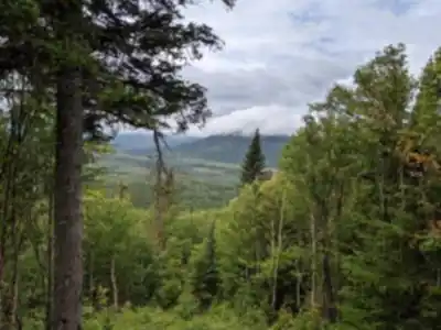
One of the things that makes hiking Mont Grand-Fonds interesting is that the environment doesn't stay the same throughout. You start in denser woodland where the canopy closes in and the trail feels quiet and enclosed. As you gain elevation, the forest opens up — the light changes, the wind picks up slightly, and the views start to appear between the trees before eventually breaking out into more exposed terrain near the top.
That shift from sheltered forest to open panorama is a big part of what makes the climb feel worthwhile. You're not just grinding uphill through identical scenery. The trail gives you something different to look at as you move, which keeps the experience engaging from start to finish.
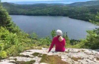
Viewpoints and what you'll see
The payoff at the top is a sweeping view over the Charlevoix landscape — layered ridgelines, rolling valleys, and on clear days, sightlines that stretch toward the St. Lawrence River. These are the kinds of views that make you want to stop and actually spend time at the high point rather than immediately turning around. If you're bringing a camera, keep it accessible as you approach the summit area.
Even before you reach the top, there are moments along the trail where the trees thin out enough to give you partial views over the surrounding terrain. These mid-route vantage points are worth pausing at, especially if the light is good or the sky is doing something interesting.
Wildlife and forest atmosphere
The wooded sections of the trail are where you're most likely to encounter wildlife. Deer are occasionally spotted in the area, and the forest is active with bird life — worth slowing down and listening for if that's part of what you enjoy about being outside. The best approach is to keep your pace steady and quiet, and scan the edges of the trail rather than just the path directly in front of you.
Even without a wildlife sighting, the forest atmosphere at Mont Grand-Fonds is a draw in itself. The enclosed sections of the trail have that particular quiet that you only get in mature woodland — muffled sound, filtered light, and a sense of being genuinely away from things.
On-site facilities
The site has cozy lodges and picnic areas, which gives you options for how you want to wrap up the day. A picnic after the hike is a practical choice — especially if you've pushed to the higher viewpoints and want time to rest before driving back. Pack something easy to eat without much setup, and bring a layer to throw on while you cool down. Even on warm days, sitting still after a climb can feel chilly, particularly if you're in an exposed spot near the trailhead or a viewpoint.
Getting there and planning your day
Mont Grand-Fonds is a short drive from La Malbaie, which makes it a practical choice for a day trip or as part of a longer Charlevoix weekend. The trails are well-marked and maintained, so navigation isn't something you need to stress about — the route is easy to follow even through the sections where the forest can look similar in multiple directions.
Before you arrive, it's worth thinking about what kind of day you want. If the goal is the summit views, plan for the full moderate route and give yourself time at the top. If you're with kids or a group that wants a more relaxed outing, the site also offers options for a lower-key walk without committing to the full elevation gain. Either way, sturdy footwear with good traction will make the uphill sections noticeably more comfortable, and a small daypack with water and a snack is all you really need.
Recommended gear for this trail


Ready to go?
Everything you need to know before you goStarting Point
To get to the mont grand-fonds trails, you must go to Baie-Saint-Paul. From there, take Route 138 East towards Saint-Siméon. After passing through the village, turn left onto Route 299 and continue to the end. The trailhead is on the right.
When?
How much?
- Hiking shoes Essential
- → Salomon Elixir Tour Mid WP · 203.38 $
- Layered clothing Essential
- Rain jacket Essential
- Trekking poles
- → Black Diamond Trail Ergo Cork · 69.99 $
- Headlamp
- → Petzl Actik Core 625 · 103.95 $
FAQ - Frequently asked questions
Everything you need to knowThe Essential Hiking Checklist
Everything you need for your next hike. Bilingual, printable, 1 page.
Download the free checklistSimilar hikes nearby
Discover other trails you might enjoy

Mont Du Lac Des Cygnes
Charlevoix

Parc National Des Hautes-gorges-de-la-rivière-malbaie
Charlevoix

Parc National Des Grands-jardins
Charlevoix

Mount Morrios
Charlevoix

Sentiers Pédestres Les Éboulements
Charlevoix

Sentier Des Caps De Charlevoix
Charlevoix
Hiking near Quebec City
40 trails to explore ~135 km away
We work hard to provide the most up-to-date and error-free data possible. If something seems incorrect, let us know! Your contribution helps the whole community.
Hikers' opinions