

Ready to explore Mont du Dôme? Here's everything you need to know before you go!
Discover the trail

Available trails
| Trails | Distance | Elevation | Duration | Difficulty | GPX |
|---|---|---|---|---|---|
| 0.8 km | 0 m | 15min | Beginner | ||
| 11.6 km | 0 m | 2h30 | Intermediate | ||
| 14 km | 250 m | 3h30 | Intermediate | ||
| 3.1 km | 0 m | 41min | Intermediate | ||
| 2.6 km | 0 m | 35min | Intermediate | ||
| 2.2 km | 0 m | 29min | Intermediate | ||
| 7.8 km | 0 m | 2h | Intermediate | ||
| 9.2 km | 0 m | 2h | Intermediate | ||
| 105 km | 400 m | 24h | Advanced | ||
| 10 km | 0 m | 2h30 | Advanced | ||
| 10 km | 0 m | 2h30 | Advanced |
Trail description
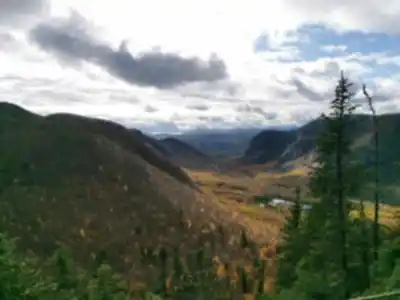
Mont du Dôme is a rewarding hiking destination in the Charlevoix region of Quebec, located within Zec des Martres. It's the kind of place that rewards you for seeking it out. The mountain sits in a landscape that feels genuinely quiet and unhurried, with the kind of natural variety that makes a hike feel like more than just a workout. Forest sections, open meadows, and a summit with wide-open views over the surrounding hills and the St. Lawrence River — it all comes together in a way that feels distinctly Charlevoix.
The mountain reaches an elevation of approximately 1,000 meters, with a 400-meter elevation gain that makes for a real ascent. The hike forms a 7.8 to 10.5 km loop, and the recommended clockwise route takes you up the steeper sections first. With the terrain variety and elevation involved, expect to spend approximately 2.5 to 3 hours on the trail, making it a solid half-day outing with time to linger at the top.
Why hike Mont du Dôme
The main draw here is the combination of terrain variety and the summit payoff. Unlike hikes that keep you locked in the same environment from start to finish, Mont du Dôme moves you through different settings — dense forest, open meadow, and exposed ridgeline — so the experience keeps shifting as you climb. That variety makes the time pass quickly and gives you a lot to look at along the way.
The trails are well-marked and maintained, which takes the navigation stress out of the equation. The difficulty is rated moderate to challenging, depending on your fitness level and which direction you take the loop. Clockwise (recommended) features steep sections with large rock scrambles; counter-clockwise offers a more gradual approach. This makes it accessible for experienced hikers while remaining achievable for those with solid fitness.
Trail experience and terrain
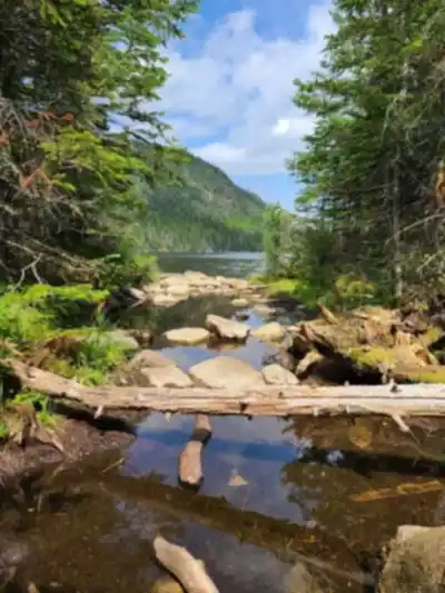
The route winds through the landscape rather than charging straight up the slope, which keeps the ascent feeling manageable and gives you time to actually take in what's around you. In the forested sections, you're moving through dense greenery with that characteristic Charlevoix quiet — the kind of stillness where you notice the light filtering through the canopy and the sound of your own footsteps on the trail.
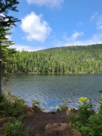
As the trail opens into meadow sections, the character shifts noticeably. These stretches feel brighter and more exposed, and they're often where you first start to get a sense of how much elevation you've gained. The views begin to open up here before fully delivering at the summit.
At the top, the panorama is the highlight: sweeping views over the rolling hills of Charlevoix and out toward the St. Lawrence River. It's a wide, layered scene — water, hills, and distance — that feels like a genuine reward after the climb. This is the kind of summit view that makes you want to sit down for a few minutes rather than immediately turning around.
Wildlife and what to watch for
The area is home to local wildlife, and hikers occasionally spot deer as well as a range of bird species along the route. Your best chance of seeing something is to move at a steady pace and keep noise down, particularly in the forested sections where animals tend to stay closer to cover. Even if wildlife doesn't make an appearance, the natural setting carries its own appeal — the transitions between forest, meadow, and open summit keep the scenery interesting throughout.
What to pack
A few basics will make the hike more comfortable:
- Sturdy hiking boots for grip and ankle support on the ascent, descent, and rocky scrambles
- Plenty of water, especially if you plan to spend time at the summit
- A camera or charged phone — the views over the St. Lawrence River and surrounding hills are worth capturing
- A light layer, since temperatures at elevation can feel cooler than at the trailhead
Because the trails are well-marked, navigation is straightforward. That said, it's always a good habit to pay attention to trail signs at junctions, especially on a first visit.
Getting there and parking
Mont du Dôme is located in Zec des Martres and is accessible year-round from Route 381, approximately 2 kilometers from Mont du Lac-des-Cygnes. The trailhead is reachable by car from Quebec City (about 1.5 hours), making it a realistic day trip for anyone based in the region. The trailhead has parking available, so you can pull in, get your gear sorted, and head straight to the trail.
Trail etiquette and leaving it as you found it
The natural setting is what makes Mont du Dôme worth visiting, and keeping it that way is straightforward. Stick to designated trails throughout the hike — this is especially important in the meadow sections, where vegetation can be more sensitive to foot traffic and erosion. Pack out everything you bring in, including food scraps, so the area stays clean for the next group and wildlife isn't drawn to litter along the trail.
These habits matter more in quieter, less-visited spots like this one, where the lack of heavy foot traffic is part of what keeps the experience feeling natural and unhurried.
Services and amenities
This information may vary by season.
Recommended gear for this trail


Ready to go?
Everything you need to know before you goStarting Point
You must follow route 138 east from Baie-Saint-Paul and then route 381 north to the welcome station, at kilometer 10.6. A white house is located on the right, behind the old museum.
The trailhead is at kilometer 23.2 of route 381, north of the village of Saint-Urbain, the Dome parking lot is 2 km north of Mont-du-Lac-des-Cygnes.
When?
How much?
- Hiking shoes Essential
- → Salomon Elixir Tour Mid WP · 203.38 $
- Layered clothing Essential
- Rain jacket Essential
- Trekking poles
- → Black Diamond Trail Ergo Cork · 69.99 $
- Headlamp
- → Petzl Actik Core 625 · 103.95 $
FAQ - Frequently asked questions
Everything you need to knowThe Essential Hiking Checklist
Everything you need for your next hike. Bilingual, printable, 1 page.
Download the free checklistSimilar hikes nearby
Discover other trails you might enjoy

Mont Du Lac Des Cygnes
Charlevoix

Parc National Des Hautes-gorges-de-la-rivière-malbaie
Charlevoix

Parc National Des Grands-jardins
Charlevoix

Mount Morrios
Charlevoix

Sentiers Pédestres Les Éboulements
Charlevoix

Sentier Des Caps De Charlevoix
Charlevoix
Hiking near Quebec City
40 trails to explore ~105 km away
We work hard to provide the most up-to-date and error-free data possible. If something seems incorrect, let us know! Your contribution helps the whole community.
Hikers' opinions