Hiking Parc de la Pointe-aux-roches - panoramic view
--°C
Loading...
See forecast →

Hiking in the Parc de la Pointe-aux-roches: trails, map and practical info

Abitibi-Témiscamingue • Quebec

5.0 Appreciated by 7 hikers
François Dumaine
By François DumaineContributor since 2016Updated 23/06/2026
Difficulty
Easy
Distance
12 km
Elevation
400 ft
Duration
4h
Max altitude
1,200 ft
Dogs
Allowed

Escape to Abitibi-Témiscamingue's wilderness on this easy 12 km trail featuring panoramic views and rich biodiversity. A 1h30 adventure through lush forests near La Sarre, perfect for wildlife spotting and connecting with nature's tranquility.

Recommended for :
Beginners

Ready to explore Parc de la Pointe-aux-roches? Here's everything you need to know before you go!

Discover the trail

4 community photos

Available trails

Trails Distance Elevation Duration Difficulty GPX
10 km 2h30 Beginner
Click a trail to see it on the map

Trail description

Trail options and difficulty

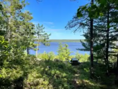
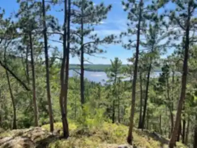
Pointe-aux-roches is described as offering trails that vary in difficulty, so it can work for both seasoned hikers and people who are newer to trails. That variety is part of what makes the destination practical: you can adjust your outing to your energy level, the weather, or who you're hiking with.

The structured info for Pointe-aux-roches lists an easy hike with a distance of 12 km, about 400 m of elevation gain, and an estimated duration of approximately 4 hours. Because the trails are well-marked, it's also a good place to focus on pacing and enjoying the surroundings rather than worrying about route-finding. If you're hiking with a mixed group, the range of difficulties in the area can help keep everyone comfortable.

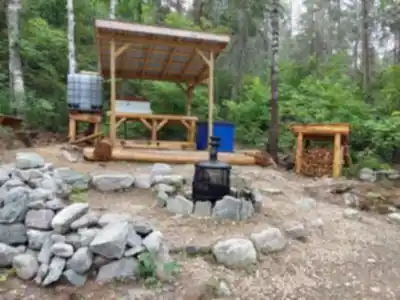
Services and amenities

Parking Icon Parking
Toilet Icon Toilet
Shelter Icon Shelter
Bridge Icon Bridge
Picnic table Icon Picnic table
Swim Icon Swim
Rustic camping Icon Rustic camping

This information may vary by season.

Recommended gear for this trail

LGPO Pick
Elixir Tour Mid WP
Salomon
Elixir Tour Mid WP
4.5 (2847 reviews)
Waterproof mid-height boot ideal for rocky terrain
203.38 $
See price
Daylite Plus 20L
Osprey
Daylite Plus 20L
4.7 (3215 reviews)
Lightweight and versatile for day hikes
109.99 $
See price
Most Popular
Wide Mouth 1L
Nalgene
Wide Mouth 1L
4.8 (12540 reviews)
Unbreakable and BPA-free — a hiking essential
23.11 $
See price
Best Value
Trail Ergo Cork
Black Diamond
Trail Ergo Cork
4.4 (1456 reviews)
Comfortable cork grip for long ascents
69.99 $
See price
Actik Core 625
Petzl
Actik Core 625
4.6 (1893 reviews)
USB rechargeable with 600 lumens for early starts
103.95 $
See price
Affiliate links — LGPO may earn a commission at no extra cost to you.

Ready to go?

Everything you need to know before you go

Where?

Address
Not available
GPS coordinates
47.4894736, -79.070646
Phone
Not available

Starting Point

To get to the Pointe-aux-roches trails, you must go to the municipality of La Sarre, in Abitibi-Témiscamingue. From there, go to the Lac-aux-Sables road and follow the signs to the trails.

The trailhead for the Pointe-aux-roches Park trails is located at the west end of the park, on Principale Street.

When?

Opening hours
From sunrise to sunset
Varies by season
Best season
Fall
Spectacular colors
Best time
Early morning
Less crowded
Weather (next days)
Loading

How much?

Entry fees
Adult
Free
Child
Free
What to bring?
Gear
Download the PDF checklist
Water & food
2L minimum
No water point on the trail
Bring energy snacks for a 4h+ hike
Good to know
Park rules
Dogs allowed
Safety
Download the GPX before you go
Limited cellular coverage on the trail
Slippery after rain
Be careful on rocky sections
In an emergency
Emergency
911
Parking GPS
47.4894736, -79.070646
Center
Not available

Hikers' opinions

5.0
2 Reviews
R2
Review 2
Feb 3, 2024
Great hiking trails! I highly recommend it. If you want to do all the loops be prepared to spend there most of the day. The 12km trail system has multiple interconnected paths, so you can easily spend 4-6 hours exploring everything. The facilities are excellent with toilets, shelters, and even swimming opportunities. Perfect for families since dogs are welcome and there are picnic areas throughout the park.
R1
Review 1
Jan 15, 2024
There are numerous well marked trails of varying degrees of difficulty. They are generally well maintained. The terrain varies and the views along the lake are spectacular. The 12km network offers something for everyone, with 400m of elevation gain spread across multiple loops. The lakeside sections are definitely the highlight, and with amenities like picnic tables and shelters, it makes for a perfect day out. Parking isn't free but the trail access is.

FAQ - Frequently asked questions

Everything you need to know
Easy
400.00 m
1200.00 m
4h
Yes
No
Yes
No
Yes, the Pointe-aux-roches trail is rated as easy difficulty, making it perfect for beginners and hikers of all skill levels. The 12 km distance with 400m elevation gain provides a manageable challenge without being too strenuous.
The Pointe-aux-roches trail typically takes about 1 hour and 30 minutes to complete, covering a distance of 12 km. Your actual hiking time may vary depending on your pace and how often you stop to enjoy the scenery.
Yes, dogs are permitted on the Pointe-aux-roches trail. Make sure to keep your dog on a leash and clean up after them to preserve the natural environment for other visitors.
Access to the Pointe-aux-roches trail is free, though parking fees may apply. The trail offers excellent value with amenities including toilets, shelters, picnic tables, and opportunities for swimming and rustic camping.
The Pointe-aux-roches trail offers comprehensive facilities including parking, toilets, shelters, bridges, picnic tables, swimming areas, and rustic camping options. These amenities make it ideal for both day hikes and longer outdoor adventures.
Didn't find your answer?
Free 1 pages

The Essential Hiking Checklist

Everything you need for your next hike. Bilingual, printable, 1 page.

Download the free checklist
Top 10 best hiking in Abitibi-Témiscamingue
Our ranking based on hiker reviews

Hiking near Gatineau

48 trails to explore ~342 km away

View trails
Did you spot an error?

We work hard to provide the most up-to-date and error-free data possible. If something seems incorrect, let us know!

Update : June 2026