Hiking La Bannik - panoramic view
--°C
Loading...
See forecast →

Hiking in La Bannik: trails, map and practical info

Abitibi-Témiscamingue • Quebec

4.6 Appreciated by 18 hikers
François Dumaine
By François DumaineContributor since 2016Updated 29/05/2026
Difficulty
Easy
Distance
4 km
Elevation
100 m
Duration
1h15
Max altitude
100 m
Dogs
Allowed

Just 10 minutes from Ville-Marie in Abitibi-Témiscamingue, this 4 km easy trail hugs the shores of Lake Témiscamingue. Complete the loop in 1h15 with your leashed dog—and enjoy free access year-round on groomed paths through mature forest.

Recommended for :
Beginners

Ready to explore La Bannik? Here's everything you need to know before you go!

Discover the trail

2 community photos

Available trails

Trails Distance Elevation Duration Difficulty GPX
4 km 0 m 53min Beginner
Click a trail to see it on the map

Trail description

la bannik is located 135 kilometers from Rouyn-Noranda, 240 kilometers from Val-d'Or and Amos and 500 kilometers from Toronto.

Whether it's a couple's vacation, a family vacation, a vacation with friends or a secluded resort, this place has enchanted all its visitors.

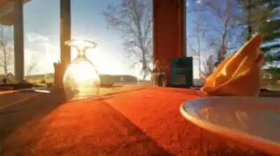
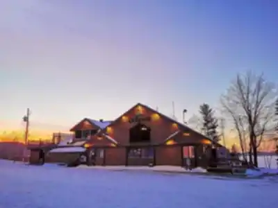
In Abitibi-Témiscamingue, only 10 minutes from Ville-Marie, the la bannik tourist complex welcomes sportsmen, campers and anyone else under its large mature trees on the shores of Lake Témiscamingue.

Whether in summer or winter, the several kilometers of marked snowshoeing and cross-country skiing trails groomed by la bannik will delight sports enthusiasts.

Tourists coming from urban areas or even from rural areas are amazed at the beauty of the mountains in the la bannik area! But also, they find themselves excited about all the activities that this site offers.

The services provided will quickly make your stay very pleasant. You will also appreciate the privacy offered by la bannik.

Please note that leashed dogs are welcome in case you want to walk there with your dog.

Access fee:

Fortunately, the Bannik is open throughout the entire year. And admission to this site is free for adults and children!

Services and amenities

Parking Icon Parking
Reception Icon Reception
Toilet Icon Toilet
Belvedere Icon Belvedere
Lodging Icon Lodging
Restaurant Icon Restaurant
Swim Icon Swim
Camping Icon Camping

This information may vary by season.

Ready to go?

Everything you need to know before you go

Where?

Address
862 Chem. du Vieux Fort, Duhamel-Ouest, QC J9V 1N7, Canada
GPS coordinates
47.2930721, -79.45114660000002
Phone
(819) 622-0922

Starting Point

To get there from Ville-Marie, you need to  take Highway 101 south for about 5km. Then turn right onto Chemin du Vieux-Fort and then follow the signs.

Note that several free parking lots are available on site.

When?

Opening hours
8 a.m. to 9 p.m.
Varies by season
Best season
Fall
Spectacular colors
Best time
Early morning
Less crowded
Weather (next days)
Loading

How much?

Entry fees
Adult
Free
Child
Free
What to bring?
Gear
  • Hiking shoes Essential
  • Layered clothing Essential
  • Rain jacket Essential
  • Trekking poles
  • Headlamp
Download the PDF checklist
Water & food
2L minimum
No water point on the trail
Bring energy snacks for a 4h+ hike
Good to know
Park rules
Dogs allowed
Safety
Download the GPX before you go
Limited cellular coverage on the trail
Slippery after rain
Be careful on rocky sections
In an emergency
Emergency
911
Parking GPS
47.2930721, -79.45114660000002
Center
(819) 622-0922

Hikers' opinions

4.6
8 Reviews
M
Marcus
Nov 3, 2025
This trail delivered exactly what I was looking for in a morning hike. The 4 km route is straightforward and manageable, perfect for maintaining a steady pace. Spring foliage created a stunning backdrop, and I encountered wildlife along the path. The natural beauty combined with the easy difficulty level makes this destination highly appealing for outdoor enthusiasts seeking a quick nature escape.
J
Jennifer
Oct 22, 2025
Visiting during autumn revealed beautiful seasonal colors throughout the landscape. Although temperatures were cool, the trail remained pleasant and relatively quiet. The 4 km hike felt refreshing and peaceful. However, additional directional markers highlighting notable plant species or natural features would enhance the experience. Overall, it's a solid choice for those seeking a tranquil outdoor adventure.
S
Sarah
Aug 14, 2025
La Bannik proved to be an excellent choice for a family outing. The well-maintained trail spans 4 kilometers and offers an easy pace suitable for children of all ages. We appreciated the peaceful atmosphere and spotted several bird species throughout our visit. The surrounding nature felt pristine and welcoming, making it a memorable experience we'd gladly repeat.
D
David
Jun 18, 2025
La Bannik exceeded my expectations as a hidden gem in the region. The easy terrain and moderate 100-meter elevation gain make it accessible for various fitness levels. The trail is well-marked and the natural surroundings are genuinely impressive. I appreciated the peaceful setting and the opportunity to disconnect from daily routines. This destination deserves more recognition among outdoor enthusiasts.
C
Claire
Mar 9, 2025
The trail offers a pleasant walk through nature with decent scenery. The 4 km distance is manageable and the easy difficulty makes it accessible. However, the experience felt somewhat ordinary compared to other regional trails. The facilities were adequate, though the parking situation could be clearer for first-time visitors. It's a decent option for casual hikers seeking a straightforward outdoor activity.

FAQ - Frequently asked questions

Everything you need to know
Easy
100.00 M
100.00 M
8 a.m. to 9 p.m.
1h15
Yes
No
Yes
Yes
Yes, La Bannik offers both camping and lodging options, making it ideal for extended stays. The site also features a restaurant and swimming areas, so you can enjoy a full outdoor experience beyond just hiking.
Didn't find your answer?
Free 1 pages

The Essential Hiking Checklist

Everything you need for your next hike. Bilingual, printable, 1 page.

Download the free checklist
Top 10 best hiking in Abitibi-Témiscamingue
Our ranking based on hiker reviews

Hiking near Barrie

146 trails to explore ~323 km away

View trails
Did you spot an error?

We work hard to provide the most up-to-date and error-free data possible. If something seems incorrect, let us know!

Update : June 2026