

Ready to explore Site Historique Des Chutes De Plaisance? Here's everything you need to know before you go!
Discover the trail

Trail description
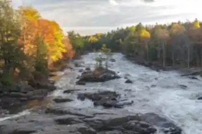
The waterfalls: the reason most people come
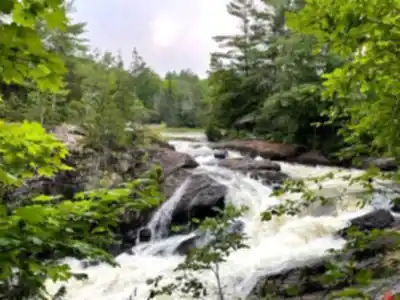
The falls are the centrepiece, dropping more than 60 metres in total. That steady roar of cascading water gets louder as you move closer, and the atmosphere near the water shifts noticeably—cooler air, occasional mist at the better viewpoints, and a constant natural soundtrack that makes even a short stretch of trail feel more immersive than it might otherwise. It's the kind of sensory experience that's hard to replicate anywhere else in the region, and it's why this site works as a destination rather than just a trail to check off a list.
The falls also create some of the best photography opportunities on the route. Between the moving water, the forest backdrop, and the light that filters through the canopy, there are plenty of moments worth stopping for. Keep your phone or camera accessible rather than buried in your pack.
Trail layout and what the route actually feels like
The trail network at Site Historique Des Chutes De Plaisance covers 5.2 km with around 150 m of elevation gain, and most hikers should plan for roughly 2h30 of total time including viewpoint stops. Difficulty is Moderate, which is an accurate label: the route is accessible to a wide range of hikers, but the elevation changes and natural, uneven surfaces mean you'll want to pay attention to your footing rather than just cruising on autopilot.
What makes the layout work well is the rhythm it creates. You move through quiet wooded sections, then the sound of the falls pulls you back toward the water and a viewpoint opens up, then you're back into the trees again. It's a satisfying back-and-forth that means you're not waiting until the end of the hike for the payoff—the highlights are distributed throughout the route. The trails are well-maintained and clearly built to support a range of visitors, from people looking for a purposeful hike to those who want a slower, more exploratory pace with lots of stops.
The historical layer: North Nation Mills and the river's industrial past
The "historique" in the name reflects genuine history. In the 19th century, this area was home to North Nation Mills, the first industrial village in the region, powered by the river's falls. Remnants of this sawmill community are still visible on-site today, adding a meaningful extra dimension to the hike. You're not only walking through a beautiful landscape; you're moving through a place that once had a working economy tied directly to the water you're now stopping to photograph.
Interpretive panels are placed at key points along the trails, providing context about the site's heritage and the life of the former village. They're worth slowing down for, as they connect the scenery to the site's industrial past in a way that makes the route feel more engaging, especially if you appreciate knowing the story behind a place while you're standing in it.
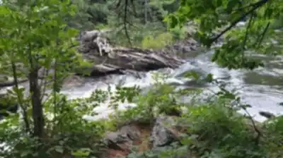
Forest, wildlife, and what you'll notice along the way
The trail edges feel alive in the way that forest-and-water environments tend to: birds active in the canopy, movement in the undergrowth, and the kind of plant variety that makes the scenery feel dynamic rather than static. The combination of lush greenery and moving water gives the whole site a layered visual quality that holds up even on a slower walk where you're not covering ground quickly.
Keep your eyes open as you move through the wooded sections. The area supports local wildlife, and even when you don't spot animals directly, the habitat has that active quality that makes you feel like you're moving through a working ecosystem rather than a manicured park.
Who this hike suits and how to pace it
The Moderate rating means this trail works for a fairly broad range of hikers. If you're experienced and want to treat it as a proper workout, the elevation gain and natural terrain give you enough to work with. If you're a casual walker or bringing someone newer to hiking, the same route can be covered at a slower pace with the focus on the falls, the views, and the historical stops—it doesn't require any technical skill, just reasonable footwear and a willingness to watch your step on uneven ground.
Families with older kids who are comfortable on natural trails will find this manageable. The distributed viewpoints and interpretive panels also help keep the route engaging for people who need a reason to stop beyond just catching their breath.
Picnic areas and taking your time on-site
Picnic areas are available on-site, which makes it easy to turn the visit into a full half-day outing rather than a quick loop. Hike first, then settle in near the sound of the water for a meal before heading back. It's a natural way to extend the experience without needing to rush anywhere.
Even if a full picnic isn't in the plan, packing some food and water is worth it. Between the viewpoints, the interpretive stops, and the time you'll naturally spend near the falls, this is a trail where breaks feel like part of the experience rather than interruptions to it.
What to bring
Comfortable hiking footwear is the main practical consideration—a Moderate route with elevation gain and natural surfaces rewards proper shoes over casual sneakers. Layers are a smart call because the air near the falls tends to run cooler than the rest of the trail, and if you're the type to linger at scenic spots, you'll appreciate having something to put on. Bring enough water for the full 5.2 km, and make sure your camera or phone is charged before you leave the trailhead.
Recommended gear for this trail


Ready to go?
Everything you need to know before you goStarting Point
The trailhead for the site historique des chutes de plaisance is located at the intersection of Rue Principale and Rue de la Chute in Plaisance.
When?
How much?
- Hiking shoes Essential
- → Salomon Elixir Tour Mid WP · 203.38 $
- Layered clothing Essential
- Rain jacket Essential
- Trekking poles
- → Black Diamond Trail Ergo Cork · 69.99 $
- Headlamp
- → Petzl Actik Core 625 · 103.95 $
FAQ - Frequently asked questions
Everything you need to knowThe Essential Hiking Checklist
Everything you need for your next hike. Bilingual, printable, 1 page.
Download the free checklistSimilar hikes nearby
Discover other trails you might enjoy

Parc Des Chutes Coulonge
Outaouais

Parc De La Gatineau
Outaouais

Centre Touristique Du Lac-simon
Outaouais

Parc Du Lac-beauchamp
Outaouais

Arbraska Laflèche
Outaouais

Parc Omega
Outaouais
Hiking near Gatineau
48 trails to explore ~48 km away
We work hard to provide the most up-to-date and error-free data possible. If something seems incorrect, let us know! Your contribution helps the whole community.
Hikers' opinions