

Ready to explore Aulus les Bains? Here's everything you need to know before you go!
Discover the trail
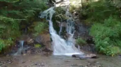
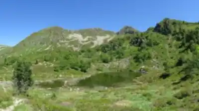
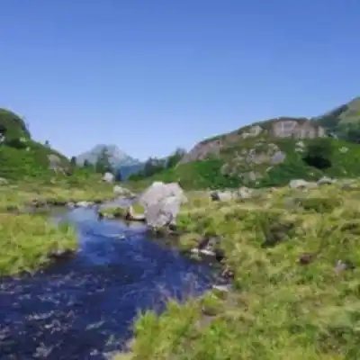
5
community photos


Trail description
Désolé, nous n'avons pas de description pour cet endroit.
Soyez le premier à partager plus d'informations sur cet endroit.
Soyez le premier à partager plus d'informations sur cet endroit.
Recommended gear for this trail
LGPO Pick

Salomon
Elixir Tour Mid WP
Waterproof mid-height boot ideal for rocky terrain
203.38 $


Affiliate links — LGPO may earn a commission at no extra cost to you.
Ready to go?
Everything you need to know before you goStarting Point
Aulus-les-Bains is located in the Ariegean Pyrenees, in the Pays du Couserans.
Aulus is 128 km from Toulouse (A64 exit N°21, E80, N117, D618, D32)
61 km from Foix (D117, D618, D32)
33 km from St-Girons (D117, D618, D32)
When?
Opening hours
No information
Varies by season
Best season
Fall
Spectacular colors
Best time
Early morning
Less crowded
Weather (next days)
Loading
How much?
Entry fees
Adult
Not available
Child
—
What to bring?
Gear
- Hiking shoes Essential
- → Salomon Elixir Tour Mid WP · 203.38 $
- Layered clothing Essential
- Rain jacket Essential
- Trekking poles
- → Black Diamond Trail Ergo Cork · 69.99 $
- Headlamp
- → Petzl Actik Core 625 · 103.95 $
Water & food
2L minimum
No water point on the trail
Bring energy snacks for a 4h+ hike
Good to know
Park rules
No dogs
Safety
Download the GPX before you go
Limited cellular coverage on the trail
Slippery after rain
Be careful on rocky sections
In an emergency
Emergency
911
Parking GPS
42.790665, 1.33937
Center
Not available
FAQ - Frequently asked questions
Everything you need to knowModerate
223.00 m
2400.00 m
2h30
No
No
The Aulus les Bains trail is rated as Moderate difficulty. With 12 km distance, 800 m of elevation gain, and an estimated duration of 2h30, this hike requires a reasonable level of fitness and hiking experience.
The Aulus les Bains trail takes approximately 2h30 to complete. This estimate accounts for the 12 km distance and 800 m of elevation gain on a moderate difficulty route.
The Aulus les Bains trail covers a total distance of 12 km. Combined with the 800 m elevation gain, this makes for a substantial half-day hike in the Ariegean Pyrenees.
Didn't find your answer?
Free
1 pages
The Essential Hiking Checklist
Everything you need for your next hike. Bilingual, printable, 1 page.
Download the free checklistSimilar hikes nearby
Discover other trails you might enjoy

Top 10 best hiking in Ariège
Our ranking based on hiker reviews
Hiking near Sydney
22 trails to explore ~4786 km away
Did you spot an error?
We work hard to provide the most up-to-date and error-free data possible. If something seems incorrect, let us know! Your contribution helps the whole community.
Hikers' opinions