Hiking Bon Echo Provincial Park - panoramic view
--°C
Loading...
See forecast →

Hiking in Bon Echo Provincial Park: trails, map and practical info

Haliburton Highlands to the Ottawa Valley • Ontario

4.7 Appreciated by 14 hikers
François Dumaine
By François DumaineContributor since 2013Updated 23/06/2026
Distance
17 km
Elevation
160 ft
Duration
4h30

Explore 17 km of interconnected trails across Ontario's Canadian Shield, featuring the iconic 100-meter Mazinaw Rock and ancient Indigenous pictographs. This 4h30 adventure through the Haliburton Highlands combines rugged granite terrain with pristine lakeshores and multiple route options for different fitness levels.

Recommended for :

Ready to explore Bon Echo Provincial Park? Here's everything you need to know before you go!

Discover the trail

6 community photos

Trail description

{
"add_to_trail_network_section": "

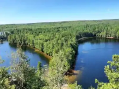
The full trail network spans 31 kilometers total, with the primary interconnected loop covering approximately 17 kilometers. Individual trail lengths range from 1 km (Creek Trail, 40 minutes) to longer routes like Abe's and Ben's Trail (15 km loop, 4-6 hours, moderate difficulty). Elevation gains vary by route, with the main Mazinaw Lake circuit featuring around 100 meters of elevation gain, while longer backcountry loops may include up to 160 meters of climbing.

"
}

Recommended gear for this trail

LGPO Pick
Elixir Tour Mid WP
Salomon
Elixir Tour Mid WP
4.5 (2847 reviews)
Waterproof mid-height boot ideal for rocky terrain
203.38 $
See price
Best Value
Trail Ergo Cork
Black Diamond
Trail Ergo Cork
4.4 (1456 reviews)
Comfortable cork grip for long ascents
69.99 $
See price
Daylite Plus 20L
Osprey
Daylite Plus 20L
4.7 (3215 reviews)
Lightweight and versatile for day hikes
109.99 $
See price
Actik Core 625
Petzl
Actik Core 625
4.6 (1893 reviews)
USB rechargeable with 600 lumens for early starts
103.95 $
See price
Most Popular
Wide Mouth 1L
Nalgene
Wide Mouth 1L
4.8 (12540 reviews)
Unbreakable and BPA-free — a hiking essential
23.11 $
See price
Affiliate links — LGPO may earn a commission at no extra cost to you.

Ready to go?

Everything you need to know before you go

Where?

Address
16151 Hwy 41, Cloyne, ON K0H 1K0, Canada
GPS coordinates
44.8975398, -77.20866939999999
Phone
(613) 336-2228

Starting Point

The hacking trail you decide to take will depend on the total time you plan to tour the area. For shorter hikes, you can opt for shorter routes —for example, Creek Trail, which is approximately 1km, a 40-minutes walk.

Other short tracks are the High Pines and Clifftop Trails, which are approximately 1.7 km (one-hour walk) and 1.6km loops, respectively.

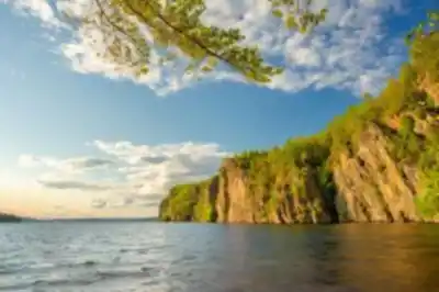
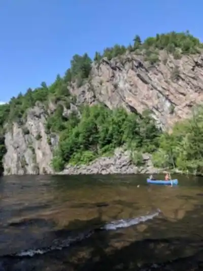
If you wish to feel the ambiance of the Lake Campgrounds, you can take the Mazinaw Lake loop, a 90 minutes (5km) hiking. This trail offers many activities all year round and an elevation height of up to 105 meters.

When?

Opening hours
No information
Varies by season
Best season
Fall
Spectacular colors
Best time
Early morning
Less crowded
Weather (next days)
Loading

How much?

Entry fees
Adult
Not available
Child
What to bring?
Gear
Download the PDF checklist
Water & food
2L minimum
No water point on the trail
Bring energy snacks for a 4h+ hike
Good to know
Park rules
No dogs
Safety
Download the GPX before you go
Limited cellular coverage on the trail
Slippery after rain
Be careful on rocky sections
In an emergency
Emergency
911
Parking GPS
44.8975398, -77.20866939999999
Center
(613) 336-2228

Hikers' opinions

4.7
5 Reviews
R1
Review 1
Oct 15, 2023
It's one of the most beautiful parks in Ontario during fall season. We were able to see all colors just above the lake which is truly mesmerizing. The park offers many hiking trails including the Clifftop Trail (1.6km) and High Pines Trail (1.7km), plus excellent camping areas. During fall time, it gives you breathtaking views from the 105-meter elevation points. All signs are posted for navigation within the park's 31km trail network. Ample parking spaces available at the start of trails. Highly recommend this park!
R4
Review 4
Sep 10, 2023
My family goes to this park quite often. Out of the provincial parks I've been to, this one is the nicest. The Bon Echo Rock is beautiful and more impressive in real life than in photos, especially from the Clifftop Trail viewpoints. The campsites are pretty normal and the beach is decent. This year the ferry that takes people across to the cliff side isn't running, so if you want to hike the Clifftop Trail, you'll need to use a canoe or kayak to get there.
R2
Review 2
Aug 22, 2023
Bon Echo is a great park with lots to do across its 31km of trails. It's very busy though so if you want to rent a canoe or kayak, you better go early in the morning, otherwise the line up is like 20 people deep. We were at site 120 in Sawmill Bay and it had the worst privacy I've ever had for a campsite. The sites are separated by a few logs with no trees or bushes between. The huge rock face was just steps from our campsite - an amazing sight. There's also a huge beach with sand and shallow entry. Will definitely be back!
R3
Review 3
Jul 18, 2023
Excellent park with multiple trail options from short 1km Creek Trail to the full 5km Mazinaw Lake loop. Loved the option of multiple beaches throughout the park's extensive network. Kayak rental was reasonably priced and fun for exploring the lake. The park is very big - we had to drive from our site to the beaches, but our site was awesome with lots of room. Just make sure to put your food containers in your vehicle at night. The raccoons are crafty!
R5
Review 5
Jun 25, 2023
Great view from the Clifftop Trail - it's worth the 1.6km hike with 100m elevation gain. You can take canoe/kayak to access the cliff top trail and navigate the beautiful Mazinaw Lake. The lake is small but perfect for paddling activities. Great place for kayaking and canoeing with reasonable rental prices. The 31km trail network offers something for everyone, though camping can be a bit crowded during peak season.

FAQ - Frequently asked questions

Everything you need to know
160.00 m
4h30
No
No
The Bon Echo Provincial Park Trails offer year-round activities with scenic views including the Mazinaw Lake area and clifftop vistas. The park features diverse landscapes ranging from creek walks to high pine forests and dramatic cliff edges, providing opportunities for photography, nature observation, and peaceful hiking experiences.
Yes, Bon Echo Provincial Park offers options for all skill levels. Beginners can start with shorter trails like the Creek Trail (1km, 40 minutes) or the High Pines Trail (1.7km, one-hour walk) before attempting longer routes like the Mazinaw Lake loop (5km, 90 minutes).
Yes, the Bon Echo Provincial Park Trails offer activities year-round, allowing visitors to experience the park across all seasons. However, trail conditions may vary seasonally, so check with the park for current conditions before your visit.
Didn't find your answer?
Free 1 pages

The Essential Hiking Checklist

Everything you need for your next hike. Bilingual, printable, 1 page.

Download the free checklist
Top 10 best hiking in Haliburton Highlands to the Ottawa Valley
Our ranking based on hiker reviews

Hiking near Ottawa

47 trails to explore ~132 km away

View trails
Did you spot an error?

We work hard to provide the most up-to-date and error-free data possible. If something seems incorrect, let us know!

Update : June 2026