

Ready to explore Mont Condor? Here's everything you need to know before you go!
Discover the trail
Available trails
| Trails | Distance | Elevation | Duration | Difficulty | GPX |
|---|---|---|---|---|---|
| 10.33 km | 567 m | 3h30 | Intermediate | GPX |
Trail description
{
"remove_sections": [
"The entire 'Amenities and Facilities' section must be removed entirely - chalets, tree houses, and the described camping/lake amenities are not verified by any source.",
"From 'Trail Experience and Views' section: remove 'you can see the famous ice wall' reference as no ice wall is documented."
],
"keep_verified": [
"2.3 km distance with 125 m elevation gain",
"Located between Val-David and Val-Morin",
"Easy difficulty rating",
"Panoramic views",
"Mont Condor Est and Mont Condor Ouest sections",
"L'Aiguille du Mont-Condor formation",
"Dogs allowed on leash",
"Family-friendly",
"Seasonal considerations (fall foliage, etc.)"
],
"html": "
Description
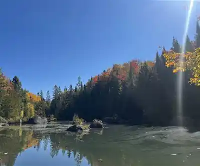
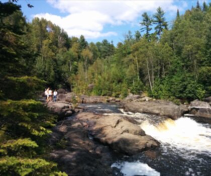
\n\nMont Condor rises from the wooded hills between Val-David and Val-Morin, just 80 kilometers north of Montreal in the heart of the Laurentians. This accessible peak draws hikers with its lush forest cover, panoramic views across the region, and well-maintained trail system that makes it an ideal destination for those seeking an easy outdoor adventure without venturing too far from the city.
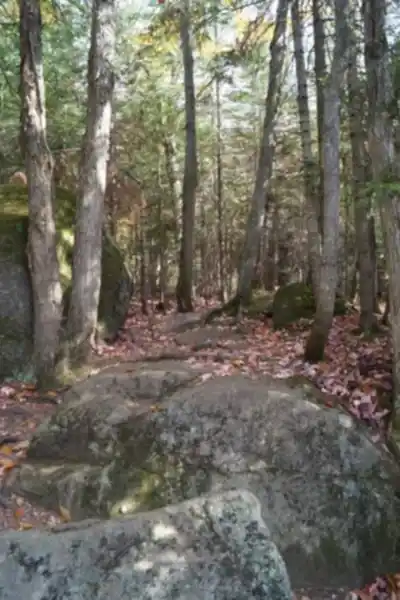
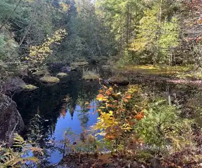
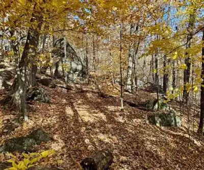
\n\nThe mountain's main hiking trail covers 2.3 kilometers with an elevation gain of 125 meters, making it suitable for hikers of all levels including families and beginners. The trail winds through dense woodland that showcases the rich and diverse flora characteristic of the Laurentian region. As you ascend, the forest canopy opens periodically to reveal glimpses of the surrounding peaks, building anticipation for the summit views.
\n\nTrail Experience and Views
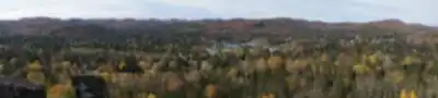
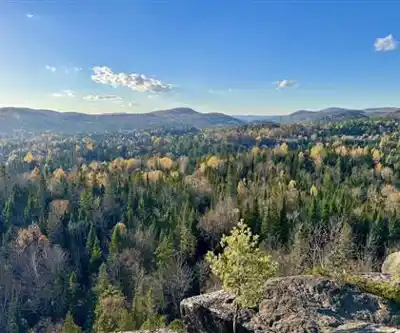
\n\nThe hike to Mont Condor's summit rewards visitors with exceptional panoramic views spanning the Laurentian region. From the top, you can take in breathtaking vistas of various surrounding peaks. These viewpoints offer excellent photo opportunities and natural rest stops where you can appreciate the scale and beauty of this popular recreational region.
\n\nThe trail passes through varied terrain that keeps the hike engaging from start to finish. You'll walk beneath a canopy of mixed forest that transforms dramatically with the seasons. During summer months, the dense greenery creates cool, shaded sections perfect for hot weather hiking. In autumn, the trees burst into brilliant displays of orange and red foliage, making this one of the region's premier destinations for fall color viewing.
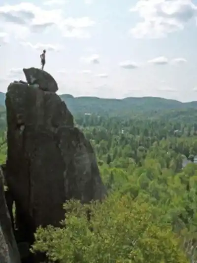
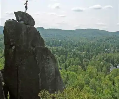
\n\nThe area features distinct sections including Mont Condor Est and Mont Condor Ouest, with notable formations such as L'Aiguille du Mont-Condor offering unique geological interest.
\n\nFamily-Friendly Options
\n\nFamilies hiking with children should look for the marked trail system, which features clear markers indicating safe routes. The marked trail network provides options for hikers of all skill levels and provides exploration opportunities throughout the area.
\n\nThe well-marked paths ensure that families can navigate confidently while enjoying the natural surroundings.
\n\nPractical Information
\n\nDogs are welcome on Mont Condor's trails provided they remain on leash throughout the hike. Pet owners are responsible for cleaning up after their animals, helping maintain the pristine natural environment that makes this destination so appealing to all visitors.
\n\nThe mountain's easy difficulty rating and relatively short distance make it accessible for most hikers of all fitness levels. The trail can typically be completed in about 1-2 hours, making it perfect for a half-day adventure that still leaves time for exploring the charming villages of Val-David and Val-Morin.
\n\nSeasonal Considerations
\n\nMont Condor offers distinct experiences throughout the hiking season. Summer provides the full green canopy experience with comfortable temperatures under the forest cover, while autumn transforms the landscape into a spectacular display of fall colors. The changing seasons affect not only the visual appeal but also the hiking conditions, with autumn potentially bringing more variable weather that requires appropriate preparation.
\n\nWhether you're seeking a quick escape from Montreal, planning a family outdoor adventure, or looking to explore one of the Laurentians' more accessible peaks, Mont Condor delivers a well-rounded hiking experience that showcases the natural beauty and recreational opportunities that make this region a beloved destination for outdoor enthusiasts.
"}
Services and amenities
This information may vary by season.
Recommended gear for this trail


Ready to go?
Everything you need to know before you goStarting Point
Trails via West Condor
Mount Condor is divided into two main sections: East Condor and West Condor. They are part of the Val-David Val-Morin regional park and are open all year long. You can start your tour with easy loops, without big climbs. Therefore, start with mont condor-Ouest. The round trip distance is 4.2 km, which can be done in two hours at a normal walking pace. If necessary, get a map of the area. You can start from the Anne-Piché parking lot, through trail D. Once you reach the parking lot, turn onto trail C to see the famous ice wall. Then take trail E and climb to the top for a great view of the entire region.
East Condor
Mount Condor-Est is reserved for experienced hikers. It is a slightly steeper hill, so much so that it could be mistaken for a mountain. The departure is from the Chalet Anne-Piché, passing by the Aiguille. The latter is a particularly rocky place, with rocks curiously cut like needles (hence its name). You can admire them at the foot of the S face and the N face of the Aiguille. The descent can be done on the Dièdre or Dülfer routes.
When?
How much?
- Hiking shoes Essential
- → Salomon Elixir Tour Mid WP · 203.38 $
- Layered clothing Essential
- Rain jacket Essential
- Trekking poles
- → Black Diamond Trail Ergo Cork · 69.99 $
- Headlamp
- → Petzl Actik Core 625 · 103.95 $
FAQ - Frequently asked questions
Everything you need to knowThe Essential Hiking Checklist
Everything you need for your next hike. Bilingual, printable, 1 page.
Download the free checklistSimilar hikes nearby
Discover other trails you might enjoy
Parc De La Rivière Doncaster
Laurentides

Parc Du Domaine Vert
Laurentides

Parc national d'Oka
Laurentides

Sommet Saint-Sauveur
Laurentides

Montagne Du Dépôt Et Montagne Du Caribou
Laurentides

Parc Régional Montagne Du Diable
Laurentides
Hiking near Laval
97 trails to explore ~60 km away
We work hard to provide the most up-to-date and error-free data possible. If something seems incorrect, let us know! Your contribution helps the whole community.
Hikers' opinions