

Ready to explore Sommet Saint Sauveur? Here's everything you need to know before you go!
Discover the trail

Trail description
Description
Sommet Saint-Sauveur is one of those hikes in the Laurentides that earns its place on the list without needing to oversell itself. At 2.5 kilometers with 416 meters of elevation gain, it's rated easy and takes around an hour and a half at a comfortable pace — short enough to fit into a half-day, rewarding enough that you won't feel like you shortchanged yourself. The trail moves through dense Laurentides forest and delivers a genuine summit viewpoint at the top, which is the kind of payoff that makes even a shorter outing feel worthwhile.
What the climb actually feels like
The elevation gain here is real — 416 meters over 2.5 kilometers is a meaningful climb — but the trail manages it in a way that feels steady rather than punishing. You're not hitting a wall of steep switchbacks right out of the gate. Instead, the path builds gradually, following the natural contours of the terrain and giving your legs time to settle into the work. By the time you're gaining the most height, you've already found your rhythm, and the thinning canopy starts giving you hints of what's waiting at the top.
The trail surface is what you'd expect from Laurentides forest hiking: packed earth, exposed roots, scattered rocks, and the occasional muddy section after rain. Nothing technical, but enough texture underfoot that you'll want to pay attention, especially when leaves are down in the fall and they're covering uneven ground. Solid footwear makes a difference here — trail runners or light hiking boots will serve you better than casual sneakers.
The forest on the way up
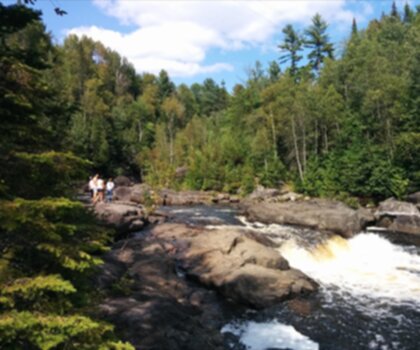
A lot of the experience at Sommet Saint-Sauveur happens before you reach the top. The trail runs through mixed Laurentides woodland — deciduous and coniferous trees sharing the same hillside — which creates a shifting environment as you climb. In the warmer months, the canopy is thick enough to keep things cool and shaded, and the forest floor has that layered, earthy quality that makes you want to slow down and look around. In fall, the same stretch turns into a patchwork of color that makes the climb feel like moving through a painting.
Wildlife is part of the picture too. Deer move through this kind of terrain, and the forest is active with birds — you'll often hear them before you see them, especially in the quieter stretches away from the trailhead. If that's something you enjoy, build in a few slow moments rather than pushing straight through. The forest rewards patience.
The summit view
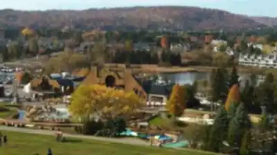
The top of Sommet Saint-Sauveur opens up into panoramic views over the surrounding Laurentides landscape — forests, valleys, and the layered ridgelines that define this part of Quebec. On a clear day, the visibility is wide and the view has real depth to it. It's the kind of summit where you naturally want to stay longer than you planned, turning to look in different directions and watching how the light moves across the terrain below.
Plan to spend some time up there rather than treating it as a quick photo stop. Bring water and a snack, and if you're visiting when there's any wind, a light layer — the summit can feel noticeably cooler than the sheltered forest below. The contrast between the enclosed, shaded trail and the open summit is one of the things that makes this hike stick with you.
Who this hike works for
The easy rating and manageable distance make Sommet Saint-Sauveur a solid choice for mixed groups. Newer hikers get a genuine Laurentides experience — real forest, real elevation, real views — without needing technical skills or committing to a full-day effort. More experienced hikers can use it as a quick morning outing or pair it with other trails in the area to build out a longer day.
It also works well for families, as long as younger kids are comfortable with uneven terrain and a sustained climb. The trail doesn't have exposed scrambling or anything that requires hands-on navigation, but the roots and rocks mean you'll want to keep an eye on smaller hikers on the way up and especially on the descent.
Seasonal considerations
Late spring through early fall is when trail conditions are most reliable — dry footing, full forest cover, and clear summit views. Summer brings the densest canopy and the best shade on the climb, while fall turns the forest into one of the better leaf-peeping routes in the region. Spring can be muddy, particularly in the lower sections of trail, so adjust your footwear expectations accordingly.
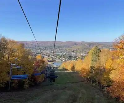
In winter, the character of the area shifts significantly. Saint-Sauveur is well known for its ski slopes, and the surrounding terrain takes on a quieter, snow-covered feel. Snowshoeing is part of the winter picture here, though conditions and trail access can vary — check locally before heading out in the colder months.
Pairing the hike with Saint-Sauveur village
One of the practical advantages of hiking at Sommet Saint-Sauveur is how easily it pairs with time in the town of Saint-Sauveur itself. The village has local restaurants and shops that make it easy to extend your day without driving far. Since the hike comes in under two hours, you'll have plenty of energy left when you're done — enough to sit down for a proper meal and explore a bit before heading home. It's a natural combination that works especially well if you're visiting with people who have different appetites for outdoor activity.
Recommended gear for this trail


Ready to go?
Everything you need to know before you goStarting Point
To access the hiking trails, head to the main parking lot located at 350 Avenue Saint-Denis, Saint-Sauveur, QC J0R 1R3. This is the primary starting point for the trails in the area.
When?
Tuesday: 8:30 AM – 10:00 PM
Wednesday: 8:30 AM – 10:00 PM
Thursday: 8:30 AM – 10:00 PM
Friday: 8:30 AM – 10:00 PM
Saturday: 8:30 AM – 10:00 PM
Sunday: 8:30 AM – 10:00 PM
How much?
- Hiking shoes Essential
- → Salomon Elixir Tour Mid WP · 203.38 $
- Layered clothing Essential
- Rain jacket Essential
- Trekking poles
- → Black Diamond Trail Ergo Cork · 69.99 $
- Headlamp
- → Petzl Actik Core 625 · 103.95 $
FAQ - Frequently asked questions
Everything you need to knowTuesday: 8:30 AM – 10:00 PM
Wednesday: 8:30 AM – 10:00 PM
Thursday: 8:30 AM – 10:00 PM
Friday: 8:30 AM – 10:00 PM
Saturday: 8:30 AM – 10:00 PM
Sunday: 8:30 AM – 10:00 PM
The Essential Hiking Checklist
Everything you need for your next hike. Bilingual, printable, 1 page.
Download the free checklistSimilar hikes nearby
Discover other trails you might enjoy
Parc De La Rivière Doncaster
Laurentides

Parc Du Domaine Vert
Laurentides

Parc national d'Oka
Laurentides

Mont Condor
Laurentides

Montagne Du Dépôt Et Montagne Du Caribou
Laurentides

Parc Régional Montagne Du Diable
Laurentides
Hiking near Laval
97 trails to explore ~46 km away
We work hard to provide the most up-to-date and error-free data possible. If something seems incorrect, let us know! Your contribution helps the whole community.
Hikers' opinions