

Ready to explore Mount Colden, New York? Here's everything you need to know before you go!
Discover the trail
Trail description
Description
Mount Colden stands as the eleventh highest peak in the Adirondack High Peaks, offering one of the most distinctive and challenging hiking experiences in New York's wilderness. Named after David S. Colden, an investor in the McIntyre Iron Works in 1836, this mountain briefly carried the name "Mount McMartin" the following year before reverting to its original designation. What sets Mount Colden apart from its neighboring peaks is the dramatic Trap Dike—a massive crevice that cuts straight up the mountain's face, creating an unmistakable landmark visible from Avalanche Lake below.
The mountain presents hikers with multiple route options, each offering a different perspective on the rugged terrain of the MacIntyre Range. Whether you choose the maintained trails or venture up the challenging Trap Dike, you'll be rewarded with breathtaking views that encompass Algonquin Peak, Iroquois Peak, and the pristine waters that dot this wilderness landscape.
Trail Options and Approaches
Mount Colden offers three distinct approaches, with two following maintained trails and one requiring serious mountaineering skills. The most popular starting point is the Adirondak Loj trailhead, which provides access to both maintained routes after an initial hike to the Avalanche Lean-Tos.
The northeast approach, established in 1966, takes hikers past the serene waters of Lake Arnold before beginning the summit push. This route replaced an earlier, steeper trail that climbed the southeast face and was abandoned by 1975. The path involves crossing several false summits that can test your determination, but the gradual elevation gain makes it more manageable for most hikers. From the Avalanche Lean-Tos, head southeast to reach Lake Arnold and connect with this northeast route.
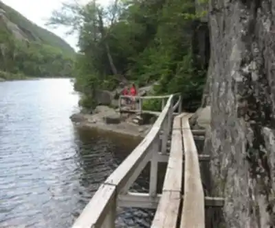
The southwest approach offers a more direct but steeper ascent, beginning from Lake Colden. To reach this trailhead from the Adirondak Loj, hike southwest through Avalanche Pass, where you'll pass the stunning Avalanche Lake before arriving at Lake Colden. The steeper grade means you'll gain elevation quickly, but it also means your legs will feel the burn more intensely as you push toward the summit.
For those seeking an alternative starting point, the southwest approach can also be accessed from the Upper Works trailhead, providing a different perspective on the approach to Lake Colden.
The Trap Dike Challenge
The most adventurous route up Mount Colden follows the famous Trap Dike directly from Avalanche Lake. This approach does not follow a maintained trail and demands serious caution, proper equipment, and mountaineering experience. The route is extremely steep in places and involves navigating a long slide followed by a short bushwhack to reach the summit.
The Trap Dike presents unique challenges that set it apart from typical hiking trails. The rock can be loose and unstable, weather conditions can change rapidly, and the exposure increases significantly as you climb higher. This route should only be attempted by experienced hikers with proper gear, including helmets and potentially ropes, depending on conditions.
What to Expect on the Mountain
Mount Colden's terrain varies dramatically depending on your chosen route. The maintained trails wind through dense Adirondack forest, where you'll encounter typical High Peaks vegetation and potentially spot wildlife common to the region. The false summits on the northeast approach can be mentally challenging, as each crest reveals another rise ahead, but they also provide opportunities to rest and take in expanding views of the surrounding wilderness.
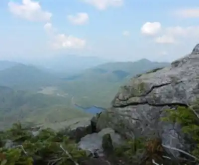
As you gain elevation, the forest gives way to more exposed terrain, and the views begin to open up dramatically. The summit offers panoramic vistas of the High Peaks region, with the distinctive profiles of neighboring mountains creating a jagged horizon line. Lake Placid and other water bodies sparkle in the distance, while the vast Adirondack wilderness stretches in every direction.
The mountain's position within the MacIntyre Range provides particularly stunning perspectives of Algonquin Peak and Iroquois Peak, two of the region's most prominent summits. These views are especially spectacular during fall foliage season when the forest canopy explodes in brilliant reds, oranges, and yellows.
Planning Your Hike
With a total distance of 21.6 kilometers and an elevation gain of 1,437 meters, Mount Colden represents a very hard hiking challenge that typically requires 6 to 10 hours to complete. The wide time range reflects the significant difference in difficulty between the maintained trails and the Trap Dike route, as well as variations in hiker experience and trail conditions.
Weather can change rapidly in the High Peaks, and Mount Colden's elevation makes it particularly susceptible to sudden storms and temperature drops. Even on warm summer days, the summit can be significantly cooler and windier than the trailhead. Proper layering and rain gear are essential regardless of the forecast.
The High Peaks Information Center serves as an excellent resource for current trail conditions, weather updates, and safety information specific to Mount Colden and the surrounding area. Their staff can provide valuable insights into trail conditions and help you choose the most appropriate route based on your experience level and current conditions.
Historical Context
The area's rich history adds depth to your hiking experience. Figures like Ebenezer Emmons contributed significantly to our understanding of the region's geology and natural features, naming many landmarks during his explorations of these mountains. Alexander Ralph documented early expeditions throughout this rugged terrain while promoting conservation efforts that help preserve the pristine environment hikers enjoy today.
This historical legacy of exploration and conservation continues to shape how we experience and protect the High Peaks region, ensuring that future generations can enjoy the same wilderness challenges and natural beauty that draw thousands of hikers to Mount Colden each year.
Recommended gear for this trail


Ready to go?
Everything you need to know before you goStarting Point
To access the hiking trails, you can start at several trailheads. One popular starting point is the Adirondack Loj Trailhead, located at 1002 Adirondack Loj Road, Lake Placid, NY 12946. This trailhead provides parking and is a common entry for hikers heading into the High Peaks region. Another option is the Upper Works Trailhead, situated at the end of Upper Works Road in Newcomb, NY. Both trailheads offer access to different routes leading to your destination.
When?
How much?
- Hiking shoes Essential
- → Salomon Elixir Tour Mid WP · 203.38 $
- Layered clothing Essential
- Rain jacket Essential
- Trekking poles
- → Black Diamond Trail Ergo Cork · 69.99 $
- Headlamp
- → Petzl Actik Core 625 · 103.95 $
FAQ - Frequently asked questions
Everything you need to knowThe Essential Hiking Checklist
Everything you need for your next hike. Bilingual, printable, 1 page.
Download the free checklistSimilar hikes nearby
Discover other trails you might enjoy

Algonquin Peak, New York
Adirondacks

Big Slide Mountain, New York
Adirondacks

Boundary Peak, New York
Adirondacks

Crane Mountain
Adirondacks
Avalanche Pass
Adirondacks
Ampersand Mountain, New York
Adirondacks
Hiking near Lake Placid
0 trails to explore ~17 km away
We work hard to provide the most up-to-date and error-free data possible. If something seems incorrect, let us know! Your contribution helps the whole community.
Hikers' opinions