

Ready to explore Algonquin Peak, New York? Here's everything you need to know before you go!
Discover the trail
Trail description
Description
Algonquin Peak stands as New York's second-highest mountain and one of the most demanding climbs in the Adirondack High Peaks. Rising to 4,867 feet within the MacIntyre Range in the town of North Elba, Essex County, this summit delivers a genuine alpine experience that's hard to match anywhere in the Northeast. The mountain's name carries historical weight, reportedly marking the boundary between Algonquian and Iroquois territories in centuries past — a reminder that this landscape has been significant to people for a very long time.
The numbers tell part of the story: 13.36 kilometers round trip, 1,559 meters of elevation gain, rated very hard, with an estimated 6 hours and 45 minutes of hiking time for a strong, fit party moving efficiently. What the numbers don't fully capture is the relentless nature of the climb. Algonquin is widely considered steeper than nearby Mount Marcy despite packing nearly as much vertical gain into a shorter distance. You'll feel that difference in your legs long before you reach the summit.
Getting There
The standard approach starts at the Adirondak Loj trailhead near Heart Lake, just outside Lake Placid. This is the most popular access point for the MacIntyre Range and makes Algonquin achievable as a challenging day hike for well-prepared parties. From the trailhead, you'll follow the blue-blazed Van Hoevenberg Trail for roughly 0.9 miles through mixed forest before reaching the junction with the yellow-blazed MacIntyre Range Trail. That junction is where the real climb begins.
An alternative approach via the Boundary Trail from Lake Colden offers a steep, narrow 2.1-mile route to the summit from the southeast. This option is significantly more serious than the standard route — poor trail markings combined with steep, slippery slides formed by stream erosion make both navigation and footing genuinely treacherous. Only hikers with strong route-finding skills and solid backcountry experience should consider it.
The Climb
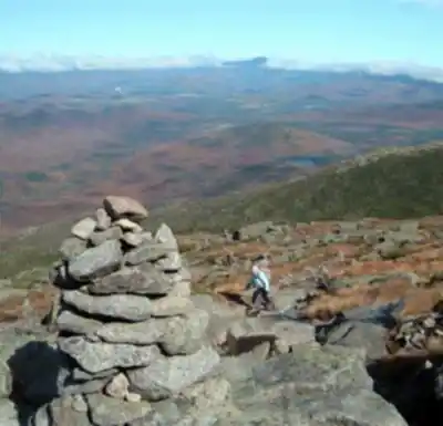
Once you're on the MacIntyre Range Trail, the trail wastes little time getting steep. The lower sections move through mixed hardwood and coniferous forest, offering a reasonable warm-up before the terrain shifts. As you gain elevation, the path becomes increasingly rocky and technical, and you'll begin encountering the rock slides that define Algonquin's upper mountain — exposed bedrock chutes carved by water and weather over time. These sections demand careful foot placement and steady nerves, and they become more frequent and more exposed the higher you climb.
Wet conditions transform these slides from challenging to genuinely hazardous. If rain is in the forecast or the rocks are damp from recent precipitation, expect to work harder and move more carefully through these sections. There's no shortcut around them — they're simply part of what Algonquin is.
The final push to the summit breaks above treeline into true alpine terrain. The transition is striking: stunted krummholz gives way to open rock and low-growing alpine vegetation, and suddenly the sky opens up in every direction. The summit itself sits on exposed bedrock and offers commanding 360-degree views of the surrounding High Peaks, including Wright Peak, Mount Marcy, and the Great Range stretching to the east.
Alpine Zone and Conservation
The alpine ecosystem above treeline on Algonquin represents one of the southernmost examples of this habitat type in eastern North America, and it's genuinely fragile. The plants growing in the cracks and hollows of that summit rock — sedges, mosses, rare alpine species — can take decades to recover from a single careless boot placement. Stay on designated paths and on bare rock whenever possible. This isn't just a suggestion; it's the difference between a healthy summit and a degraded one.
Algonquin's popularity has put real pressure on this ecosystem, and the response has been active management. You'll be required to sign in at the trailhead — both for safety tracking and conservation data. On busy days, Summit Stewards are stationed on the mountain to educate hikers about the alpine environment and ensure that regulations are followed. These aren't enforcement officers looking to hand out fines; they're knowledgeable people who genuinely care about the place and are worth talking to.
Dogs are permitted on the trail but must remain leashed at all times, both to protect sensitive vegetation and to minimize disturbance to wildlife in the area.
Weather and Conditions
The exposed summit offers zero shelter from wind, rain, or sudden temperature swings. Weather in the High Peaks can shift quickly and dramatically, and the alpine zone amplifies everything — wind speeds, temperature drops, and the chill factor of an incoming storm. Even on a warm summer day at the trailhead, conditions at the summit can be significantly colder and windier than you'd expect. Carry layers, rain gear, and enough food and water to handle a longer day than planned.
Winter conditions can linger well into spring at this elevation, and fall can bring early snow and ice. Outside of summer, crampons and an ice axe may be necessary equipment rather than optional extras — the rock slides that are merely challenging in dry summer conditions become serious hazards when iced over.
Nearby Options
The Adirondak Loj trailhead connects to a broad network of trails throughout this section of the Adirondack Park. Marcy Dam, reachable via a shorter hike from the same starting point, offers a more moderate outing with views of the High Peaks and serves as a popular camping destination for multi-day trips. Lake Colden, accessible through various trail combinations, provides a scenic backcountry lake experience that contrasts nicely with Algonquin's exposed alpine character.
For hikers working through the Adirondack 46 — the list of peaks over 4,000 feet — Algonquin is often combined with neighboring Wright Peak in a single day, since Wright's summit is accessible via a short spur trail off the MacIntyre Range Trail on the way up or down.
Algonquin is a serious mountain that rewards serious preparation, and the views from that exposed summit, earned through hours of steep and technical climbing, are among the finest the Adirondacks have to offer.
Services and amenities
This information may vary by season.
Recommended gear for this trail


Ready to go?
Everything you need to know before you goStarting Point
To access the hiking trails, you can start at the Adirondak Loj parking area. The address is 1002 Adirondack Loj Road, Lake Placid, NY 12946. This is a popular starting point for many hikes in the area. Another option is to begin from the Upper Works Trailhead, located at the end of Upper Works Road in Newcomb, NY. Both trailheads provide access to various routes leading to your destination.
When?
How much?
- Hiking shoes Essential
- → Salomon Elixir Tour Mid WP · 203.38 $
- Layered clothing Essential
- Rain jacket Essential
- Trekking poles
- → Black Diamond Trail Ergo Cork · 69.99 $
- Headlamp
- → Petzl Actik Core 625 · 103.95 $
FAQ - Frequently asked questions
Everything you need to knowThe Essential Hiking Checklist
Everything you need for your next hike. Bilingual, printable, 1 page.
Download the free checklistAlternatives and suggestions
Similar hikes nearby
Discover other trails you might enjoy

Big Slide Mountain, New York
Adirondacks

Avalanche Pass
Adirondacks
Crane Mountain
Adirondacks

Boundary Peak, New York
Adirondacks
Ampersand Mountain, New York
Adirondacks
Round Pond
Adirondacks
Hiking near Lake Placid
0 trails to explore ~15 km away
We work hard to provide the most up-to-date and error-free data possible. If something seems incorrect, let us know! Your contribution helps the whole community.
Hikers' opinions