

Ready to explore Mount Marcy, New York? Here's everything you need to know before you go!
Discover the trail
Trail description
Description
Mount Marcy stands as New York's highest peak at 5,343 feet (1,629 m), earning its place as the crown jewel of the Adirondack High Peaks Wilderness Region. Known as Tewawe'éstha in Mohawk, this imposing summit sits in Essex County near the town of Keene, drawing thousands of hikers each summer who come for its commanding views and the bragging rights that come with conquering the state's tallest mountain.
The mountain holds special significance as the headwaters region for the Hudson River. Lake Tear of the Clouds, nestled between Mount Marcy and Mount Skylight, feeds into Feldspar Brook and the Opalescent River, though the geography here is more complex than it first appears—the main branch of the Opalescent River actually originates two miles south of the lake and runs longer than Feldspar Brook.
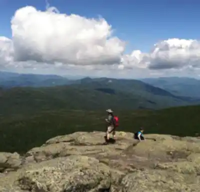
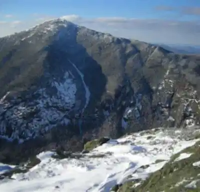
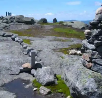
Most of Mount Marcy remains cloaked in dense forest until you reach the final few hundred feet, where the landscape transforms dramatically. Above treeline, you'll encounter a harsh alpine environment dominated by rocky outcrops, hardy lichens, and low-growing shrubs. Two commemorative plaques mark the summit, celebrating both the mountain's centennial and the peak itself. The exposed summit offers spectacular 360-degree views that stretch north to the volcanic Montregian Hills in Quebec's St. Lawrence Valley, including distant Mont St. Hilaire, while southern vistas encompass Lake Champlain, Burlington, and the sprawling southern Adirondacks.
Trail Routes and Access
Four main trails lead to Mount Marcy's summit, with the Van Hoevenberg Trail serving as the most popular and direct route. Starting from the Adirondack Loj parking area near Heart Lake, this trail covers 7.4 miles one-way, making for a 14.8-mile round trip with moderate to steep climbing throughout.
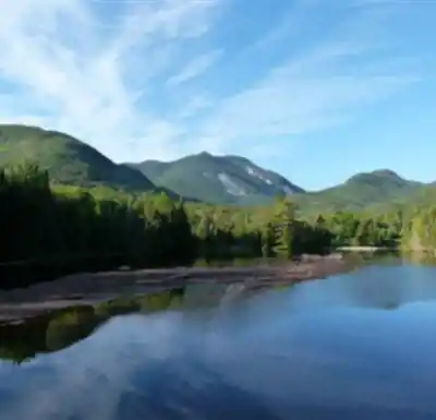
The Van Hoevenberg Trail begins with a relatively gentle 2.3-mile approach to the former Marcy Dam site. Hurricane Irene washed out the original dam in 2011, but the area still provides excellent views of Mount Colden, Avalanche Mountain, and Wright Peak. You'll cross the stream below where the dam once stood before continuing toward the trail register, where paths diverge toward various High Peaks summits.
Beyond the dam site, the trail passes several lean-tos and designated campsites before reaching Avalanche Pass junction after about 100 yards. Follow the path along Phelps Brook for 0.8 miles until you encounter the junction where the trail splits left toward Phelps Mountain—stay right toward Marcy. The next 3 miles bring you to a relatively flat section offering views across the Marcy basin before reaching Indian Falls.
From Indian Falls, expect a gradual but steady climb for just under two miles until you reach a junction at 6.2 miles where a left fork heads toward Keene Valley. Bear right and continue for another 0.8 miles of increasingly steep, rocky terrain that leads to Marcy's windswept summit.
For those seeking longer approaches, the Johns Brook Trail from the Garden parking area in Keene Valley offers an 18-mile round trip with an overnight option at Johns Brook Lodge. Advanced hikers can also access the mountain from southern trailheads at Upper Works or Elk Lake, though these represent significantly longer commitments.
Terrain and Hiking Experience
The hike to Mount Marcy delivers a comprehensive Adirondack experience, transitioning through multiple ecosystems as you gain elevation. The lower sections wind through dense hardwood and coniferous forests, with several stream crossings that can leave your feet wet—plan accordingly. The terrain becomes increasingly rocky and challenging as you approach treeline, where weather conditions can change rapidly.
The final push to the summit tests your endurance with steep, rocky scrambling across exposed granite slabs. Once above treeline, you'll be fully exposed to the elements, making weather awareness crucial. The alpine environment here is fragile and legally protected—stick to designated trails and step only on open rock to preserve the rare alpine vegetation.
Many hikers combine Mount Marcy with nearby peaks like Mount Skylight and Gray Peak for an extended adventure, though this significantly increases the challenge and time commitment. The standard Marcy hike alone typically requires 8 to 12 hours for most hikers, covering 23.8 kilometers with 965 meters of elevation gain.
Seasonal Considerations and Winter Hiking
Mount Marcy presents a formidable winter challenge that should only be attempted by experienced mountaineers. Winter conditions require snowshoes for most of the trail, while the exposed upper reaches demand crampons or microspikes for safe travel. Temperatures at the summit run at least 20 degrees colder than valley temperatures, not accounting for potentially severe windchill effects.
Winter hikers must carry additional safety gear including multiple non-cotton insulation layers, a headlamp with spare batteries, extra food, windproof outer layers, goggles, face protection, and emergency overnight supplies. The combination of extreme cold, potential whiteout conditions, and technical terrain makes winter ascents serious undertakings requiring proper training and experience.
Practical Information
Access Mount Marcy via the Adirondack Loj Road, reached by following Route 73 through Lake Placid and turning onto Adirondack Loj Road to its terminus. The large parking area charges a $10 fee, collected at a toll booth near the entrance. Arrive early during peak season, as this popular trailhead fills quickly on weekends and holidays.
The trail can become muddy and confusing in wet conditions, making it essential to stay on marked paths to minimize environmental impact. Several stream crossings along the route can be challenging during high water periods. Before starting your hike, ensure you have emergency contact information for park rangers and carry a basic first aid kit—the remote location means help can be hours away in case of injury.
As one of the Adirondack 46 High Peaks, Mount Marcy represents a rite of passage for serious Adirondack hikers. Located 5 miles from the nearest road and accessible only on foot, this peak offers a genuine wilderness experience in one of the Northeast's most pristine mountain environments.
Services and amenities
This information may vary by season.
Recommended gear for this trail


Ready to go?
Everything you need to know before you goStarting Point
From the parking lot located at Adirondak Loj (plan to pay a $10 US parking fee), follow the signs to Marcy Dam, then to Mount Marcy using the Van Hoevenberg Trail. During the ascent, take the time to make a short round trip to see Indian Falls. A wooden sign will indicate the location of these beautiful waterfalls. A little further on, once on Marcy's rocky shoulder, you must follow the cairns (rock piles) and yellow painted markers to reach the summit. The return trip is by the same path.
When?
How much?
- Hiking shoes Essential
- → Salomon Elixir Tour Mid WP · 203.38 $
- Layered clothing Essential
- Rain jacket Essential
- Trekking poles
- → Black Diamond Trail Ergo Cork · 69.99 $
- Headlamp
- → Petzl Actik Core 625 · 103.95 $
FAQ - Frequently asked questions
Everything you need to knowThe Essential Hiking Checklist
Everything you need for your next hike. Bilingual, printable, 1 page.
Download the free checklistAlternatives and suggestions
You can create a superb loop down to Skylight and Gray Mountains on your return. To do this, just proceed on the same path from the top of Marcy to achieve a spot called Four Corners. You can quickly reach Mount Skylight's summit from here, where the view is also outstanding. Please read the Skylight and Gray Mountains data sheet for more information on this loop.
Similar hikes nearby
Discover other trails you might enjoy

Algonquin Peak, New York
Adirondacks

Big Slide Mountain, New York
Adirondacks

Boundary Peak, New York
Adirondacks

Crane Mountain
Adirondacks
Avalanche Pass
Adirondacks
Ampersand Mountain, New York
Adirondacks
Hiking near Lake Placid
0 trails to explore ~19 km away
We work hard to provide the most up-to-date and error-free data possible. If something seems incorrect, let us know! Your contribution helps the whole community.
Hikers' opinions