

Ready to explore Mount Skylight, New York? Here's everything you need to know before you go!
Discover the trail
Trail description
Description
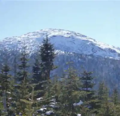
Mount Skylight is the fourth highest peak in New York State and one of the most rewarding summits in the Adirondack High Peaks. At 30.42 kilometers round-trip with 1,501 meters of elevation gain, this is a serious undertaking — most hikers budget around 10 hours and 30 minutes, and many choose to make it an overnight trip rather than push it as a day hike. What makes Skylight stand out among its neighbors isn't just the elevation — it's the summit itself: broad, open, and remarkably flat, with an almost alpine feel that's genuinely rare in the densely forested Adirondacks.
The name says it all. Where most High Peaks summits are hemmed in by dense spruce and fir right up to a small rocky perch, Skylight opens up into a wide, exposed zone with unobstructed views in every direction. On a clear day you can pick out Mount Marcy to the north, the sweep of the Great Range, and ridge after ridge fading into the distance. That kind of panorama takes real effort to earn here — and that's exactly why hikers who've done it tend to come back.
The Summit and Its Traditions
Two large cairns anchor either end of Skylight's elongated summit, and they've grown considerably over the years thanks to a well-known 46er tradition: carry a rock to the top and add it to one of the cairns, and you'll supposedly be rewarded with good weather on future adventures. Believe it or not, these stone towers have become genuine landmarks — a visible record of the thousands of hikers who've made the long haul out here. The exposed summit also means conditions can shift fast, so even if the forecast looks solid when you start, pack layers and rain gear.
Getting There: Route Options
There's only one trail to the actual summit, branching off from the Four Corners junction — a critical waypoint that sits between Skylight and Mount Marcy. The name gives it away: four trails converge here, which means you have three different ways to reach that junction, each with its own character.
The most popular approach comes from the west via the Feldspar Brook Trail, starting from the camping areas at Flowed Lands. This route has a lot going for it beyond just getting you to the summit — it passes Lake Tear of the Clouds, widely considered the source of the Hudson River, and opens up the possibility of adding a bushwhack up trailless Gray Peak if you're feeling ambitious. The terrain shifts noticeably as you gain elevation: the walking around Flowed Lands is relatively gentle, but the climb toward Four Corners gets steep and rocky.
A second option approaches from the north by descending from Mount Marcy, which works well if you're planning to bag multiple peaks in one push. Marcy and Skylight together make for a natural pairing, and many hikers tackle both on the same trip. The third approach, via Panther Gorge and Elk Lake from the southeast, is the most remote and demanding of the three — it's not the route to choose for a first visit, but experienced hikers looking for solitude will find it delivers.
What the Terrain Actually Feels Like
The early miles of any approach to Skylight move through classic Adirondack forest — hardwoods giving way to conifers, with stream crossings, rooty sections, and the occasional muddy stretch that comes with the territory. As you climb, the trees get shorter and the trail gets rockier. Navigation stays straightforward on the marked trails, but the rocky terrain near the summit demands attention, especially if clouds roll in and visibility drops.
The transition from dense forest to open summit is one of the best moments on this hike. There's a real sense of emergence as the trees thin out and the sky opens up — after hours of enclosed forest travel, stepping onto that broad, flat summit feels like arriving somewhere genuinely different. The Opalescent River, which runs through the area, adds both scenery and reliable water sources along several of the approach routes, though treatment is always necessary.
Planning and Logistics
Given the very hard difficulty rating and the distance involved, most people treat Mount Skylight as a backpacking trip rather than a day hike. The camping areas at Flowed Lands are the most convenient base for the western approach, and designated sites exist throughout the region. Permits and camping regulations in the High Peaks Wilderness Area apply, so check current requirements before heading out.
Water is available along most routes, but always treat it. Sturdy hiking boots are essential — the rocky terrain and long distances will punish lighter footwear. Trekking poles earn their weight on the steep sections and at stream crossings. Weather on the exposed summit can deteriorate quickly regardless of what the valley forecast says, so a full set of layers and reliable rain protection should be in your pack no matter the season.
Seasonal Notes
Summer and fall offer the most accessible conditions for the majority of hikers. Spring can be genuinely difficult — mud season in the Adirondacks is no joke, stream levels run high, and the weather stays unpredictable well into May. Winter ascents of Skylight are possible but require real mountaineering experience, crampons or snowshoes, and careful attention to conditions on that exposed summit, which becomes a serious place in a winter storm.
Whatever season you choose, the remote location means you're largely on your own out there — self-sufficiency isn't optional on a route like this, it's the baseline expectation.
Recommended gear for this trail


Ready to go?
Everything you need to know before you goStarting Point
To access the hiking trails, you can start from the Adirondack Loj parking area. The address is 1002 Adirondack Loj Road, Lake Placid, NY 12946. From there, follow the trailhead signs leading to your destination.
When?
How much?
- Hiking shoes Essential
- → Salomon Elixir Tour Mid WP · 203.38 $
- Layered clothing Essential
- Rain jacket Essential
- Trekking poles
- → Black Diamond Trail Ergo Cork · 69.99 $
- Headlamp
- → Petzl Actik Core 625 · 103.95 $
FAQ - Frequently asked questions
Everything you need to knowThe Essential Hiking Checklist
Everything you need for your next hike. Bilingual, printable, 1 page.
Download the free checklistSimilar hikes nearby
Discover other trails you might enjoy

Algonquin Peak, New York
Adirondacks

Big Slide Mountain, New York
Adirondacks

Boundary Peak, New York
Adirondacks

Crane Mountain
Adirondacks
Avalanche Pass
Adirondacks
Ampersand Mountain, New York
Adirondacks
Hiking near Lake Placid
0 trails to explore ~20 km away
We work hard to provide the most up-to-date and error-free data possible. If something seems incorrect, let us know! Your contribution helps the whole community.
Hikers' opinions