

Ready to explore Nippletop, New York? Here's everything you need to know before you go!
Discover the trail

Trail description
Description
Nippletop stands as the highest peak in Essex County at 4,620 feet (1,409 meters), commanding impressive views across the Adirondack wilderness. This distinctive mountain earned its name from its twin peaks, which create a memorable silhouette against the sky. Located in the town of Elizabethtown and positioned near Keene Valley, Nippletop forms part of both the Colvin Range and the broader Dix Range, making it a significant landmark in this rugged corner of New York's Adirondack Park.
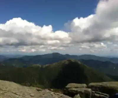
The mountain's strategic position offers hikers exceptional panoramic views of the surrounding high peaks. From the summit, you'll enjoy breathtaking vistas of the Great Range, which has inspired countless adventurers over the years, including explorer H.G. Leach who documented his journeys through this challenging terrain. The summit provides clear sightlines to several notable neighboring peaks, creating a 360-degree showcase of Adirondack wilderness.
Trail Access and Route
Most hikers begin their journey to Nippletop from the Ausable Club, which serves as the primary gateway to this remarkable hiking area. The club provides access to an extensive network of trails that connect Nippletop with other notable peaks in the region, making it possible to plan extended ridge walks or multi-peak adventures.
The hike to Nippletop covers 21.1 kilometers with 1,400 meters of elevation gain, making this a very challenging undertaking that typically requires 8 to 10 hours to complete. The trail demands good physical conditioning and proper preparation, as hikers will encounter steep ascents, rocky terrain, and potentially challenging weather conditions at elevation.
Those approaching via Lake Road will find themselves traveling through some of the most pristine wilderness in the Adirondacks. This route immerses hikers in dense forests where diverse wildlife thrives among the lush landscapes that characterize this protected region of New York's wilderness.
Geographic Setting
Nippletop's position within the Adirondack high peaks region creates a complex network of ridges and valleys. The mountain is flanked to the northeast by Dial Mountain, creating opportunities for experienced hikers to traverse between peaks. To the east, Nippletop faces Dix Mountain across the dramatic gap of Hunters Pass, while to the west it looks toward Mount Colvin across Elk Pass. These geographic relationships make Nippletop an excellent vantage point for understanding the layout of the surrounding wilderness.
The mountain's watershed patterns reflect the complex geography of the region. The west side of Nippletop drains into the West Inlet of Elk Lake, with water eventually flowing through The Branch of the Schroon River, then the Hudson River, and finally reaching New York Bay. The south and east sides feed into the East Inlet of Elk Lake, following a similar path toward the Atlantic.
More interesting from a geographic perspective, the northeast side of Nippletop contributes to an entirely different watershed system. Water from this slope flows into the headwaters of the North Fork of the Boquet River, then into Lake Champlain, continuing north through Canada's Richelieu River and the Saint Lawrence River before reaching the Gulf of Saint Lawrence. The northwest side follows yet another route, draining into Gill Brook, then the East Branch of Ausable River, and into Lake Champlain.
Hiking Experience
The ascent of Nippletop provides hikers with a comprehensive Adirondack experience, from dense hardwood forests at lower elevations to exposed rocky summits above treeline. The trail's length and elevation gain ensure that hikers will experience multiple forest zones and changing terrain as they climb toward the distinctive twin peaks.
Early sections of the hike wind through mature forests where hikers can observe the diverse wildlife that makes the Adirondacks home. The lush landscapes along the approach routes showcase the ecological richness of this protected wilderness area. As elevation increases, the forest composition changes, and hikers begin to encounter the more challenging rocky terrain that characterizes the higher elevations.
The final approach to Nippletop's summit typically involves scrambling over exposed rock faces and navigating steep, technical sections that require careful attention to route-finding and safety. Weather conditions can change rapidly at this elevation, making proper gear and clothing essential for a safe ascent.
From the summit, the effort invested in reaching Nippletop pays dividends in spectacular views. The Great Range stretches out in a dramatic display of peaks and valleys, while the surrounding wilderness extends to the horizon in every direction. On clear days, hikers can identify dozens of named peaks and trace the routes of trails that connect this network of summits.
The descent requires the same careful attention as the ascent, particularly on steep rocky sections where loose rock and fatigue can create hazardous conditions. The trail's length means that hikers should plan for a full day adventure and carry adequate water, food, and emergency supplies for the extended time required to complete this challenging route safely.
Ready to go?
Everything you need to know before you goStarting Point
The best way to get to the start of the trails at the Nippletop is to drive to the Elk Lake Trailhead.
When?
How much?
- Hiking shoes Essential
- Layered clothing Essential
- Rain jacket Essential
- Trekking poles
- Headlamp
FAQ - Frequently asked questions
Everything you need to knowThe Essential Hiking Checklist
Everything you need for your next hike. Bilingual, printable, 1 page.
Download the free checklistSimilar hikes nearby
Discover other trails you might enjoy

Algonquin Peak, New York
Adirondacks

Big Slide Mountain, New York
Adirondacks

Boundary Peak, New York
Adirondacks

Crane Mountain
Adirondacks
Avalanche Pass
Adirondacks
Ampersand Mountain, New York
Adirondacks
Hiking near Lake Placid
0 trails to explore ~25 km away
We work hard to provide the most up-to-date and error-free data possible. If something seems incorrect, let us know! Your contribution helps the whole community.
Hikers' opinions