

Ready to explore Sawtooth Mountains, New York? Here's everything you need to know before you go!
Discover the trail
Trail description
Description
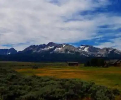
The Sawtooth Mountains represent one of the Adirondacks' most challenging and rewarding wilderness experiences. Located in Essex County within the High Peaks Wilderness Area, this rugged range offers serious hikers the chance to explore unmarked terrain far from the crowds that flock to more popular peaks like Mount Marcy or Algonquin.
What sets the Sawtooth Mountains apart is their raw, uncompromising character. These peaks demand respect and skill from anyone who ventures onto their slopes. The range consists of several distinct summits, each presenting its own technical challenges and spectacular viewpoints across the Adirondack wilderness.
Trail Conditions and Terrain
Make no mistake—hiking the Sawtooth Mountains requires advanced backcountry skills. The trails are largely unmarked, meaning you'll need to rely on map and compass navigation throughout your journey. Bushwhacking is not just likely but inevitable, as you push through dense forest sections where no clear path exists.
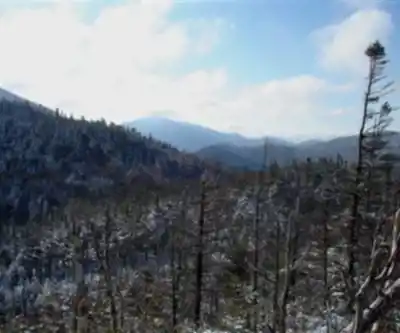
The terrain varies dramatically as you ascend. You'll start in thick hardwood and coniferous forests, where fallen logs and dense undergrowth slow your progress. As you climb higher, the forest gives way to steep, rocky sections that require careful route-finding and sure footing. The final approaches to the summits often involve scrambling over exposed rock faces and navigating around cliff bands.
Sawtooth No. 1 stands out as the most popular objective in the range, though "popular" is relative in this remote corner of the Adirondacks. The climb to this summit exemplifies everything that makes the Sawtooth range both challenging and rewarding. Expect to gain significant elevation through a combination of steep forest hiking and technical rock work.
Views and Natural Features
The effort required to reach any Sawtooth summit pays dividends in the form of panoramic views that few other Adirondack peaks can match. From the rocky summits, you'll look out over an unbroken expanse of wilderness that stretches to the horizon in every direction. The High Peaks region spreads out below, while the more distant ranges fade into blue silhouettes.
The pristine nature of this area means wildlife encounters are common and memorable. White-tailed deer move through the forests in small groups, often allowing close observation if you move quietly. Black bears inhabit these woods year-round, making proper food storage essential for any overnight trips. The diverse bird life includes species that prefer deep wilderness settings, from woodpeckers working the old-growth trees to raptors soaring above the ridgelines.
Lower Ausable Lake lies just beyond the main peaks, where the historical figure Lydia Crawford once found inspiration beside its serene waters. This pristine lake feeds into the Ausable River, which winds its way through the scenic Keene Valley toward Lake Placid. The connection between these water features and the surrounding peaks creates a landscape of remarkable beauty and ecological diversity.
Camping and Extended Adventures
The remote location and challenging access make the Sawtooth Mountains ideal for multi-day adventures. Camping opportunities exist throughout the surrounding wilderness, though you'll need to follow Leave No Trace principles and Adirondack Park camping regulations. Designated campsites are rare in this area, so you'll likely be setting up in pristine backcountry locations.
Stream crossings are frequent, and many hikers choose to camp near the clear mountain waters that flow down from the peaks. These streams provide reliable water sources, though proper filtration is essential. The sound of running water and the complete absence of human-made noise create an atmosphere of deep wilderness immersion that's increasingly rare in the modern world.
Camping under the star-filled Adirondack sky, with no light pollution for miles in any direction, offers a perspective on the natural world that day hikers miss entirely. The transition from sunset to full darkness reveals the true character of this wilderness area.
Preparation and Safety Considerations
Success and safety in the Sawtooth Mountains depend entirely on thorough preparation. A detailed topographic map and compass are non-negotiable—GPS devices can supplement your navigation but should never be your primary method in this terrain. The ability to read contour lines and identify terrain features becomes crucial when following unmarked routes through dense forest.
Cell phone service is unreliable at best throughout the range. Plan your trip assuming you'll have no ability to call for help, and inform others of your detailed itinerary before departing. Emergency situations in this remote area can become serious quickly without proper preparation and self-rescue capabilities.
Weather conditions change rapidly in the mountains, and the exposed summit areas offer little protection from wind, rain, or sudden temperature drops. Pack layers appropriate for conditions significantly worse than the forecast, and be prepared to turn back if weather deteriorates.
The estimated duration of 6 to 8 hours applies to experienced hikers moving efficiently through challenging terrain. Less experienced parties should plan for longer days and consider the physical demands of bushwhacking and route-finding, which are significantly more tiring than following marked trails.
Regional Context
The Sawtooth Mountains sit within the broader context of the Adirondack High Peaks region, offering a different experience from the more traveled routes to peaks like those in the nearby Great Range. While the Great Range attracts seasoned climbers seeking the challenge of the region's highest summits, the Sawtooth Mountains appeal to those who prioritize solitude and wilderness skills over peak bagging.
The scenic trail connections that lead toward Lake Placid and the views over Mirror Lake along Lake Road provide context for understanding how the Sawtooth range fits into the larger Adirondack landscape. These mountains represent the wild heart of a region that balances accessibility with true wilderness character.
Recommended gear for this trail


Ready to go?
Everything you need to know before you goStarting Point
To access the hiking trails, you can start at several trailheads. One option is the trailhead located at the end of Route 73, near Chapel Pond. Another starting point is the parking area on Route 9, just south of the intersection with Route 73. Both locations provide convenient access to the trails in the area.
When?
How much?
- Hiking shoes Essential
- → Salomon Elixir Tour Mid WP · 203.38 $
- Layered clothing Essential
- Rain jacket Essential
- Trekking poles
- → Black Diamond Trail Ergo Cork · 69.99 $
- Headlamp
- → Petzl Actik Core 625 · 103.95 $
FAQ - Frequently asked questions
Everything you need to knowThe Essential Hiking Checklist
Everything you need for your next hike. Bilingual, printable, 1 page.
Download the free checklistSimilar hikes nearby
Discover other trails you might enjoy

Algonquin Peak, New York
Adirondacks

Big Slide Mountain, New York
Adirondacks

Boundary Peak, New York
Adirondacks

Crane Mountain
Adirondacks
Avalanche Pass
Adirondacks
Ampersand Mountain, New York
Adirondacks
Hiking near Lake Placid
0 trails to explore ~15 km away
We work hard to provide the most up-to-date and error-free data possible. If something seems incorrect, let us know! Your contribution helps the whole community.
Hikers' opinions