

Ready to explore Kettle Valley Rail Trail? Here's everything you need to know before you go!
Discover the trail
Oh no! We don't have any photos 😢
This trail hasn't been captured yet. Be the first to share your adventure!Trail description
Description
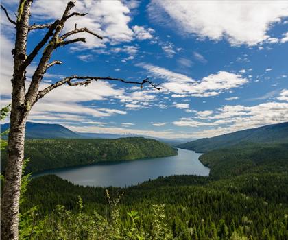
The Kettle Valley Rail Trail transforms a piece of British Columbia's railway history into one of Canada's most accessible and scenic hiking experiences. Built along the historic Kettle Valley Railway corridor that was constructed between 1910 and 1915, this 600-kilometer multi-use trail winds through the heart of the Thompson Okanagan region, offering hikers everything from gentle afternoon walks to multi-day adventures across diverse landscapes.
What sets this trail apart is its remarkable engineering heritage combined with its gentle grades and well-maintained surfaces. The original railway was designed to navigate the challenging terrain of southern British Columbia, and today's trail benefits from that careful planning. You'll find yourself walking along routes that were carved into mountainsides and bridged across deep canyons, all while maintaining gradual inclines that make the trail accessible for hikers of all skill levels.
Trail Experience and Terrain
The trail's character changes dramatically as you move through different sections, taking you through lush forests where towering conifers create natural corridors, past expansive vineyards that showcase the region's wine country, and into charming rural communities where you can glimpse local life in the Thompson Okanagan. The surface varies from packed gravel to dirt paths, but the railway's original engineering ensures you won't encounter steep grades that challenge less experienced hikers.
The crown jewel of the entire trail system is the Myra Canyon section, where the original railway's most impressive engineering feats remain intact. Here, you'll cross a series of restored wooden trestle bridges that span deep ravines and walk through tunnels carved directly into the rock. The bridges offer spectacular viewpoints where you can look down into the canyon below and across to the surrounding mountains. This section perfectly captures why the trail has become famous among photographers and social media enthusiasts, though the views are genuinely spectacular regardless of your camera skills.
As you hike different sections, you'll notice how the landscape reflects the diverse ecosystems of the Thompson Okanagan. In forested areas, the canopy provides welcome shade during hot summer days, while open sections offer expansive views of the valley systems that define this region. The trail's elevation changes are gradual enough that you'll often find yourself gaining significant height without realizing the climb.
Wildlife and Natural Features
The trail corridor supports a rich variety of wildlife that reflects the biodiversity of the Thompson Okanagan region. Deer are commonly spotted, especially during early morning or evening hikes, and you'll often hear them moving through the brush before catching a glimpse. Overhead, eagles soar on thermal currents, and you might spot them perched in tall trees along the route. Black bears do inhabit the area, so maintaining proper food storage and making noise while hiking are important safety practices, though encounters are relatively rare on the more popular trail sections.
The changing seasons bring distinct experiences along the trail. Spring hiking reveals wildflowers blooming in meadows and forest clearings, while summer offers the full green canopy and the chance to see the region's agricultural areas in their prime growing season. Autumn transforms the deciduous trees into displays of red and gold, creating some of the most photogenic hiking conditions of the year. Each season offers different wildlife activity patterns and varying trail conditions.
Planning and Preparation
The trail's accessibility from multiple points means you can tailor your hiking experience to match your interests and fitness level. Popular starting locations include Penticton, Kelowna, and Summerland, each offering different access points with varying distances and scenic highlights. Some sections bring you close to cafes and rest stops where you can resupply or take a break, while others require more self-sufficient preparation with adequate water and snacks.
Appropriate footwear is essential, though you don't need technical hiking boots for most sections. Comfortable walking shoes with good tread will handle the gravel and dirt surfaces effectively. Water requirements vary significantly depending on the season and section you choose, but carrying more than you think you'll need is always wise, especially during summer months when temperatures can climb significantly in the open sections.
The trail accommodates more than just hiking. Cycling is popular on many sections, and the gentle grades that make hiking accessible also create excellent cycling conditions. Some areas allow horseback riding, giving you options to experience the trail in different ways or return to favorite sections using different modes of travel.
Access and Logistics
The Thompson Okanagan region's road network provides multiple access points to the trail system, making it easy to plan point-to-point hikes or loop routes that bring you back to your starting location. The trail's proximity to major communities means you can easily combine hiking with other regional activities like wine tasting, lake recreation, or exploring local farmers markets.
Different access points offer distinct advantages depending on your goals. Some provide immediate access to the most scenic sections, while others allow you to warm up with easier terrain before reaching more dramatic landscapes. The trail's length means you can return multiple times to explore different sections, each offering its own character and highlights.
Whether you're planning a leisurely day hike to experience a taste of the trail's character or organizing a multi-day adventure to cover significant distance, the Kettle Valley Rail Trail provides a unique combination of historical significance, engineering marvels, and natural beauty that showcases why the Thompson Okanagan region attracts outdoor enthusiasts from across Canada and beyond.
Recommended gear for this trail


Ready to go?
Everything you need to know before you goStarting Point
The kettle valley rail trail is located in British Columbia. To get to the start of the trails, take Highway 3 east from Penticton to Keremeos. Turn north onto Highway 5A and drive for about 10 km until you reach the trailhead parking lot on the right.
When?
How much?
- Hiking shoes Essential
- → Salomon Elixir Tour Mid WP · 203.38 $
- Layered clothing Essential
- Rain jacket Essential
- Trekking poles
- → Black Diamond Trail Ergo Cork · 69.99 $
- Headlamp
- → Petzl Actik Core 625 · 103.95 $
FAQ - Frequently asked questions
Everything you need to knowThe Essential Hiking Checklist
Everything you need for your next hike. Bilingual, printable, 1 page.
Download the free checklistSimilar hikes nearby
Discover other trails you might enjoy

Big White Ski Resort
Thompson Okanagan

Cougar Canyon
Thompson Okanagan
Spectrum Lake
Thompson Okanagan
Clearwater Lake
Thompson Okanagan
Mahood Lake
Thompson Okanagan
Kentucky Lake
Thompson Okanagan
Hiking near Kelowna
45 trails to explore ~38 km away
We work hard to provide the most up-to-date and error-free data possible. If something seems incorrect, let us know! Your contribution helps the whole community.
Hikers' opinions