

Ready to explore Frosty Mountain? Here's everything you need to know before you go!
Discover the trail
Oh no! We don't have any photos 😢
This trail hasn't been captured yet. Be the first to share your adventure!Trail description
Description
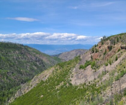
Frosty Mountain rises to 2,408 meters (7,900 feet) as one of the highest peaks in E.C. Manning Provincial Park, delivering the kind of alpine experience that keeps hikers coming back to the Thompson Okanagan region. This isn't a casual weekend stroll—the 28-kilometer round trip with 1,150 meters of elevation gain demands 8 to 10 hours and solid fitness levels, but rewards committed hikers with some of the most spectacular mountain vistas in southern British Columbia.
The Trail Experience
Your journey begins at Lightning Lake Day Use Area, where ample parking and facilities give you space to organize gear and prepare mentally for the long day ahead. The well-marked and maintained trail starts deceptively easy, winding through dense forests of towering evergreens that provide welcome shade during the initial kilometers.
As you gain elevation, the forest character shifts and opens up, revealing vibrant wildflower meadows that explode with color during the warmer months. The trail traverses diverse landscapes that keep the long approach interesting—dense timber gives way to subalpine meadows, then to increasingly rocky terrain as you push toward the summit.
One of the trail's most celebrated features appears in autumn when the larch trees transform into golden torches against the mountain backdrop. This seasonal spectacle typically peaks in late September to early October, drawing photographers and hikers willing to brave cooler temperatures for the stunning display. The contrast between the golden larches and the deep green of the surrounding evergreens creates photo opportunities that capture the essence of this high-elevation wilderness.
The final push to the summit tests your endurance as the trail becomes steeper and more exposed. Rocky switchbacks lead you above the treeline, where the landscape opens into the kind of panoramic wilderness that makes the Thompson Okanagan region famous among serious hikers. From the summit, rugged mountain ranges stretch in every direction, with serene valleys carved deep between the peaks extending as far as visibility allows.
What Makes This Trail Special
Frosty Mountain stands apart from other peaks in E.C. Manning Provincial Park because of its combination of accessibility and genuine alpine character. While the distance is significant, the trail itself remains well-maintained and clearly marked throughout, making it achievable for determined hikers without requiring technical climbing skills.
The elevation gain happens gradually rather than in brutal, leg-burning pitches. This steady climb allows you to settle into a rhythm and actually enjoy the changing ecosystems as you ascend. You'll move through distinct vegetation zones, each with its own character and wildlife, creating a sense of journey rather than just a slog to the top.
The summit views justify every step of the approach. On clear days, the panorama encompasses wave after wave of mountain ridges, showcasing the raw wilderness that defines this corner of British Columbia. It's the kind of vista that makes you understand why people become addicted to peak bagging.
Seasonal Considerations
Frosty Mountain offers dramatically different experiences depending on when you visit, and conditions can vary greatly throughout the year. Summer provides the most straightforward hiking conditions with mild temperatures and clear, dry trails. The snow typically clears from the upper elevations by late June or early July, opening the full route to the summit.
Winter transforms the entire area into a snowy wonderland that attracts snowshoeing enthusiasts, though the full summit becomes significantly more challenging and requires winter mountaineering skills. The lower elevations remain accessible for winter recreation, but anyone venturing higher needs proper avalanche knowledge and equipment.
Spring and fall present their own challenges and rewards. Spring hiking often means dealing with muddy conditions and lingering snow patches at higher elevations, but also brings the excitement of wildflowers beginning to bloom. Fall offers the spectacular larch display and crisp, clear air, though weather can turn quickly and early snow is always possible at the summit.
Always check current weather conditions and trail reports before setting out, as mountain weather can change rapidly and catch unprepared hikers off guard. The elevation gain and exposure on this trail mean that conditions at the trailhead may bear little resemblance to what you'll encounter near the summit.
Planning Your Adventure
The 28-kilometer distance and significant elevation gain make this a full-day commitment that requires proper preparation. Most hikers find the 8 to 10-hour timeframe realistic, though strong hikers may complete it faster and others may need additional time. Starting early helps ensure you're not descending in darkness, especially during shorter fall and spring days.
The trail's length means you'll need to carry sufficient water and food for the entire day, as there are no reliable water sources along the route. Pack more than you think you'll need—the combination of distance and elevation will have you burning through calories and fluids faster than usual.
For those not ready to tackle the full summit route, shorter options exist along the same trail system. You can turn around at any point and still enjoy the forest scenery and partial mountain views, though the truly spectacular panoramic vistas require getting close to the summit. The subalpine meadows make excellent turnaround points for a shorter but still rewarding day out.
Gear and Safety
Proper gear becomes essential given the trail's length and elevation. Weather can change quickly at altitude, so layers and rain protection are important even on seemingly perfect days. Sturdy hiking boots provide necessary ankle support and traction, especially on the rockier upper sections of the trail.
Navigation stays straightforward on the main trail, but carrying a map and knowing how to use it adds an important safety margin. Cell phone coverage becomes spotty at best once you gain elevation, so don't count on being able to call for help if things go wrong.
The combination of distance, elevation, and alpine exposure makes Frosty Mountain a serious undertaking that showcases why E.C. Manning Provincial Park attracts dedicated hikers from across the Pacific Northwest. This trail delivers the kind of wilderness experience and summit views that create lasting memories and often inspire return visits to explore more of what the Thompson Okanagan's high country has to offer.
Recommended gear for this trail


Ready to go?
Everything you need to know before you goStarting Point
The frosty mountain trails can be accessed from the town of Princeton, British Columbia. From Princeton, drive east on Highway 3 for approximately 15 kilometers until you reach the junction for Highway 5A. Turn left onto Highway 5A and drive for 2 kilometers until you reach the junction for the frosty mountain Forest Service Road. Turn right onto the frosty mountain Forest Service Road and drive for 6 kilometers until you reach the trailhead parking lot.
When?
How much?
- Hiking shoes Essential
- → Salomon Elixir Tour Mid WP · 203.38 $
- Layered clothing Essential
- Rain jacket Essential
- Trekking poles
- → Black Diamond Trail Ergo Cork · 69.99 $
- Headlamp
- → Petzl Actik Core 625 · 103.95 $
FAQ - Frequently asked questions
Everything you need to knowThe Essential Hiking Checklist
Everything you need for your next hike. Bilingual, printable, 1 page.
Download the free checklistSimilar hikes nearby
Discover other trails you might enjoy

Big White Ski Resort
Thompson Okanagan

Cougar Canyon
Thompson Okanagan
Spectrum Lake
Thompson Okanagan
Mahood Lake
Thompson Okanagan
Kentucky Lake
Thompson Okanagan
Myra Canyon Trail (Myra Canyon Trestles)
Thompson Okanagan
Hiking near Kelowna
45 trails to explore ~138 km away
We work hard to provide the most up-to-date and error-free data possible. If something seems incorrect, let us know! Your contribution helps the whole community.
Hikers' opinions