

Ready to explore Myra Canyon Trail (Myra Canyon Trestles)? Here's everything you need to know before you go!
Discover the trail
Trail description
Description
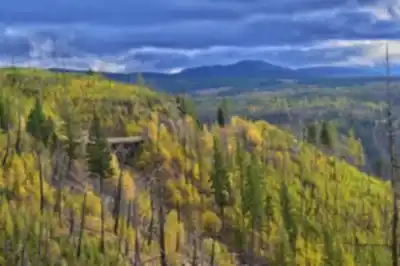
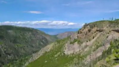
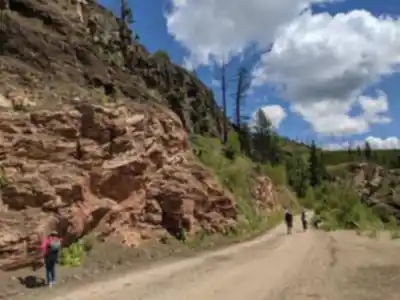
The Myra Canyon Trail follows a spectacular 12-kilometer stretch of the historic Kettle Valley Railway, offering one of British Columbia's most accessible yet rewarding hiking experiences. Located just outside Kelowna in the Thompson Okanagan region, this relatively flat trail combines stunning canyon views with fascinating railway heritage, making it perfect for hikers of all abilities who want to experience the region's natural beauty without tackling steep climbs.
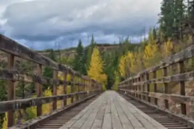
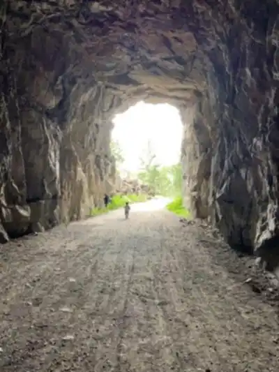
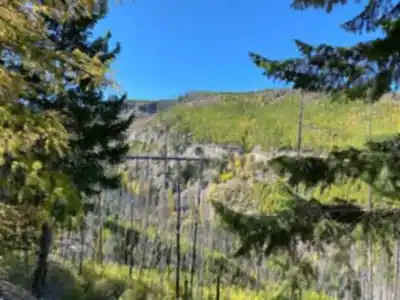
What sets this trail apart is its unique combination of engineering marvels and dramatic landscapes. You'll walk along the original railway grade, crossing 18 restored wooden trestle bridges and passing through two tunnels carved directly into the rock. The trail gains only 48 meters of elevation over its entire length, making it feel more like a scenic walk than a challenging hike, yet the views rival those found on much more difficult routes.
The Trestle Experience
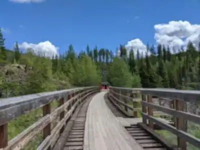
The trestle bridges are undoubtedly the trail's main attraction, and each one offers a different perspective of Myra Canyon's rugged beauty. These wooden structures, originally built in the early 1900s, have been meticulously restored to provide safe passage while maintaining their historical character. Walking across them gives you an unobstructed view straight down into the canyon below—a thrilling experience that combines the excitement of height with the security of sturdy railings.
The trestles vary in height and length, with some spanning deep gorges while others cross smaller ravines. Each crossing feels like a small adventure, offering new angles of the surrounding mountains and valleys. The two tunnels provide welcome shade on hot summer days and add an element of mystery as you emerge to discover new vistas on the other side.
Terrain and Trail Conditions
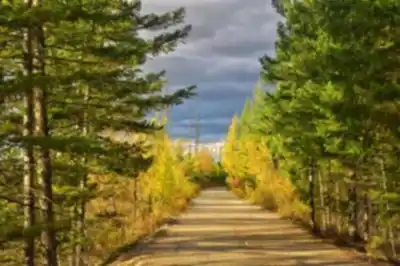
The trail surface consists of packed gravel and dirt, following the original railway bed. This makes for easy walking with minimal obstacles, though you'll encounter some loose rocks and occasional roots. The path is wide enough for comfortable two-way traffic, and the gentle grade means you can maintain a steady pace without frequent stops for steep climbs.
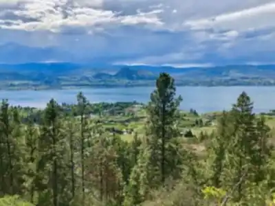
The route meanders along canyon walls, offering constant views across the valley. You'll walk through sections of mixed forest dominated by ponderosa pine and Douglas fir, with open areas that showcase the semi-arid landscape typical of the Okanagan region. The contrast between the lush forest sections and the more exposed canyon areas creates visual variety throughout your hike.
Wildlife and Natural Features
The diverse ecosystem along Myra Canyon supports a variety of wildlife that you're likely to encounter during your visit. Deer are commonly spotted grazing in the open areas, particularly during early morning or late afternoon hours. Marmots often sun themselves on the rocky outcrops, and their distinctive whistles frequently echo across the canyon. Keep your eyes on the sky for soaring eagles and hawks that ride the thermals rising from the canyon floor.
The plant life changes dramatically with the seasons, offering different experiences throughout the year. Spring brings vibrant wildflowers that dot the landscape with splashes of color against the rocky terrain. Summer showcases the hardy vegetation adapted to the region's dry climate, while autumn transforms the deciduous trees and shrubs into a brilliant tapestry of reds, oranges, and yellows that contrasts beautifully with the evergreen forest.
Seasonal Considerations
Each season offers a distinct experience on the Myra Canyon Trail. Summer provides the classic hiking experience with warm, dry conditions and excellent visibility, though it can get quite hot during midday hours. The exposed sections of trail offer little shade, so early morning or late afternoon timing works best during peak summer.
Autumn is arguably the most spectacular time to visit, when the changing foliage creates a stunning backdrop for the historic trestles. The cooler temperatures make for comfortable hiking conditions, and the clear autumn air often provides exceptional long-distance views.
Winter transforms the trail into a snowy wonderland perfect for snowshoeing or cross-country skiing. The trestles take on a magical quality when covered in snow, and the serene winter landscape offers a completely different perspective on the canyon's beauty. However, winter visitors should be prepared for potentially icy conditions on the trestles and should carry appropriate safety equipment.
Access and Logistics
The trail is easily accessible from Kelowna, making it a convenient day trip for both locals and visitors to the Okanagan Valley. You can start your hike from either Myra Station or Ruth Station, both of which offer ample parking facilities. This flexibility allows you to plan your route based on your schedule and energy level—you can hike the full 12 kilometers one way, do an out-and-back hike of any distance, or arrange transportation to hike the entire trail without retracing your steps.
The estimated hiking time of three hours assumes a leisurely pace with stops to enjoy the views and explore the trestles. Many hikers find themselves spending longer than expected as they pause to photograph the scenery and soak in the historical atmosphere.
What to Bring
Despite the trail's easy rating, proper preparation enhances your experience significantly. Water is essential, especially during summer months when the exposed sections can be quite warm. The trail offers little natural shade, so sunscreen and a hat are important for sun protection. While the terrain is generally easy, sturdy walking shoes or light hiking boots provide better traction on the gravel surfaces and loose rocks.
Snacks or a packed lunch allow you to take your time and fully enjoy the experience. Many hikers find the trestles perfect spots for breaks, offering spectacular views while you rest. A camera is almost essential given the photogenic combination of historic structures and natural beauty that defines this trail.
Recommended gear for this trail


Ready to go?
Everything you need to know before you goStarting Point
The Myra Canyon Trail is located in the Myra Canyon Provincial Park, which is about a 2-hour drive from Vancouver. From Vancouver, take Highway 1 east to Hope. In Hope, take Highway 3 south to Princeton. In Princeton, take the exit for Highway 5A (Myra Canyon). The park is located about 10 km down the road.
When?
How much?
- Hiking shoes Essential
- → Salomon Elixir Tour Mid WP · 203.38 $
- Layered clothing Essential
- Rain jacket Essential
- Trekking poles
- → Black Diamond Trail Ergo Cork · 69.99 $
- Headlamp
- → Petzl Actik Core 625 · 103.95 $
FAQ - Frequently asked questions
Everything you need to knowThe Essential Hiking Checklist
Everything you need for your next hike. Bilingual, printable, 1 page.
Download the free checklistSimilar hikes nearby
Discover other trails you might enjoy

Big White Ski Resort
Thompson Okanagan

Cougar Canyon
Thompson Okanagan
Spectrum Lake
Thompson Okanagan
Mahood Lake
Thompson Okanagan
Kentucky Lake
Thompson Okanagan
Frosty Mountain
Thompson Okanagan
Hiking near Kelowna
45 trails to explore ~16 km away
We work hard to provide the most up-to-date and error-free data possible. If something seems incorrect, let us know! Your contribution helps the whole community.
Hikers' opinions
Be the first to review!
No hiker has shared their experience yet. Share your impressions and help other hikers!