

Ready to explore Mahood Lake? Here's everything you need to know before you go!
Discover the trail
Oh no! We don't have any photos 😢
This trail hasn't been captured yet. Be the first to share your adventure!Trail description
Description
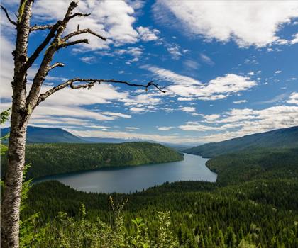
Mahood Lake sits in the heart of Wells Gray Provincial Park, offering one of British Columbia's most rewarding accessible wilderness experiences. The lake itself — 14 kilometers long and carved by glaciers over thousands of years — anchors a network of trails that range from easy waterfall walks to more demanding routes through the surrounding Cariboo Mountains. What makes this area stand out is the combination of dramatic natural features and relatively moderate terrain, putting genuine backcountry scenery within reach of hikers who aren't looking for a technical challenge.
The Trail Experience
The main hiking route at Mahood Lake covers 8 kilometers with 200 meters of elevation gain, rated easy with an estimated time of around 2.5 hours. That said, easy doesn't mean flat or uninteresting — the trail moves through varied terrain that keeps your attention throughout.
The Canim-Mahood Falls Trail is the area's most popular option, and for good reason. It takes you through mature forest to two distinct waterfall viewpoints, each with its own character. The route follows well-maintained paths through mixed stands of cedar and fir, with the forest floor covered in typical Interior BC understory. Wooden bridges cross several small creeks along the way, offering natural rest points before the trail builds toward its main payoffs.
Trail surfaces shift between soft forest duff, exposed roots, and occasional rocky sections — manageable for most hikers, but worth wearing proper footwear rather than running shoes. The dense canopy filters light into shifting patterns across the path, and as you move deeper into the forest, the sound of rushing water gradually takes over, building real anticipation before the falls come into view.
Canim Falls hits first, dropping dramatically over a rocky ledge with enough force to generate a persistent mist. That moisture supports its own small plant community right at the base of the viewpoint, and the viewing area gives you multiple angles on the cascade. Mahood Falls, further along, is a completely different experience — a multi-tiered cascade pushing through a narrow canyon. The contrast between the two makes the hike feel like two separate destinations rather than one trail with a couple of stops.
For hikers wanting more challenge, the Deception Falls Trail offers a different kind of terrain: denser forest, rockier footing, exposed outcrops, and steeper grades that require more careful foot placement. The payoff is expansive views across the Mahood Lake valley and surrounding peaks — worth the extra effort, especially if you're carrying a camera.
Wildlife and Natural Environment
The Mahood Lake area sits within BC's Interior Cedar-Hemlock biogeoclimatic zone, and the forest reflects that. Western red cedars and Douglas firs dominate the canopy, creating cathedral-like corridors along many sections of trail. The understory runs thick with devil's club, huckleberry, and various ferns that thrive in the moist conditions. In summer, fireweed, Indian paintbrush, and asters add color against the deep green backdrop.
Wildlife is a genuine part of the experience here. Moose frequent the marshy edges of the lake, particularly in early morning and evening when they come to feed on aquatic vegetation — their tracks are often visible in the soft mud along accessible shoreline sections. White-tailed and mule deer move through the forest corridors and tend to appear without much warning along quieter stretches of trail. Black bears use the area's berry patches heavily in late summer, so making noise while hiking is a practical habit rather than just a precaution.
Overhead, bald eagles work the lake's surface with impressive efficiency, their calls carrying across the valley. Gray jays are a constant trail companion — curious and bold enough to approach hikers closely. Various woodpecker species work the standing dead timber throughout the forest, and patient observers occasionally spot martens moving through the canopy.
Seasonal Conditions
The hiking season at Mahood Lake typically runs from late May through October, with the most reliable conditions in July and August. Spring hiking can be rewarding — waterfall volumes are at their peak during May and June snowmelt — but expect muddy trail surfaces and potentially high water at creek crossings. The viewing areas near the falls can also be slippery when runoff is at its highest.
By late summer and fall, water levels drop and footing near the falls becomes more stable, though the cascades have less raw volume. Fall brings its own rewards: wildlife activity picks up as animals prepare for winter, and the contrast of golden aspens against the evergreen forest creates some of the best photography conditions of the year. Weather can shift quickly in fall, so layers are essential regardless of how the morning looks.
Practical Gear and Preparation
Sturdy hiking boots are the right call for all trails here. The mist near the waterfalls keeps rocks consistently damp, and the Deception Falls Trail has enough uneven terrain to make ankle support genuinely useful rather than optional. Carry more water than you think you'll need — summer temperatures can climb in exposed sections, and while the lake and streams are abundant, any natural water source needs treatment before drinking.
A basic first aid kit makes sense given the remote location and limited cell coverage throughout most of the area. Pack a waterproof shell regardless of the forecast — the forest canopy protects you along most of the trail, but exposed viewpoints can be noticeably cooler and windier than sheltered sections. If photography is part of your plan, a tripod is worth the extra weight: the forest light often requires slower shutter speeds, and the waterfall shots benefit from a stable platform.
Access and Logistics
Mahood Lake is accessible via the Mahood Lake Road within Wells Gray Provincial Park. Road conditions vary by season — spring can be rough for low-clearance vehicles, while summer typically allows standard passenger car access to the main trailheads. Checking current road conditions before heading out is a straightforward step that can save a wasted trip.
Parking near the main trailheads fills up on busy summer weekends, often by mid-morning. Starting early gives you better parking options and puts you on trail during the hours when wildlife is most active. The area supports both day-use hiking and backcountry camping for those wanting to extend their time in the park — camping requires following provincial park regulations, including proper food storage in bear country and Leave No Trace practices throughout.
Recommended gear for this trail


Ready to go?
Everything you need to know before you goStarting Point
The mahood lake trails can be accessed from the mahood lake Recreation Site. The Recreation Site is located on the east side of the lake, about 2 km from the dam. There is a parking lot and a boat launch at the Recreation Site.
When?
How much?
- Hiking shoes Essential
- → Salomon Elixir Tour Mid WP · 203.38 $
- Layered clothing Essential
- Rain jacket Essential
- Trekking poles
- → Black Diamond Trail Ergo Cork · 69.99 $
- Headlamp
- → Petzl Actik Core 625 · 103.95 $
FAQ - Frequently asked questions
Everything you need to knowThe Essential Hiking Checklist
Everything you need for your next hike. Bilingual, printable, 1 page.
Download the free checklistSimilar hikes nearby
Discover other trails you might enjoy

Big White Ski Resort
Thompson Okanagan

Cougar Canyon
Thompson Okanagan
Spectrum Lake
Thompson Okanagan
Clearwater Lake
Thompson Okanagan
Kentucky Lake
Thompson Okanagan
Frosty Mountain
Thompson Okanagan
Hiking near Jasper
82 trails to explore ~189 km away
We work hard to provide the most up-to-date and error-free data possible. If something seems incorrect, let us know! Your contribution helps the whole community.
Hikers' opinions