

Ready to explore Health Valley Trail? Here's everything you need to know before you go!
Discover the trail
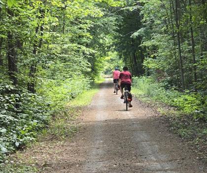
Oh no! We don't have any photos 😢
This trail hasn't been captured yet. Be the first to share your adventure!Trail description
Description
The Health Valley Trail is a pleasant 2.5-kilometer loop through the natural landscapes of the Huron, Perth, Waterloo, and Wellington region in southwestern Ontario. With only 30 meters of elevation gain and an estimated 40-minute completion time, it sits firmly in easy territory — the kind of trail that works just as well for a quick weekday escape as it does for a relaxed family outing on a Sunday afternoon.
What to Expect on the Trail
The trail moves through a mix of wooded sections and more open terrain, giving you a bit of variety without ever feeling demanding. The forest stretches provide natural shade and a quieter, enclosed feel, while the open areas shift the mood entirely — more sky, more light, and better chances of spotting local wildlife. That back-and-forth between environments keeps the walk interesting even at a short distance.
The path is well-marked and the footing is generally solid, so you don't need specialized gear to enjoy it. A pair of comfortable walking shoes or light trail runners will handle the terrain without issue under normal conditions. The 30-meter elevation change is gradual enough that it won't slow most hikers down, but it does add just enough topographic interest to keep the route from feeling completely flat.
Wildlife and Natural Features
Like many trails in this part of Ontario, the Health Valley Trail passes through habitat that supports a good mix of bird life and woodland wildlife. White-tailed deer are a common sight, especially during early morning or late afternoon when they're most active near the edges of forested areas. Birdwatchers will find the transition zones between forest and open ground particularly productive, as these edge habitats tend to attract a wider variety of species than either environment alone.
The vegetation along the trail reflects the character of southwestern Ontario's mixed forests — mature deciduous trees, shrubby understory growth, and patches of meadow that shift in appearance through the seasons. Spring brings early wildflowers and fresh green growth; summer fills in the canopy and keeps things cool in the shaded sections; fall turns the whole corridor into a patchwork of warm colors; and winter strips things back to reveal the underlying structure of the landscape for those who venture out in colder months.
Practical Information
At 2.5 kilometers, the Health Valley Trail is short enough that you won't need to pack heavily. That said, bringing water is always a good habit regardless of trail length, and a light snack doesn't hurt if you plan to take your time and enjoy the surroundings rather than moving straight through. There are no facilities directly on the trail, so plan accordingly before you head out.
The trail's manageable length and easy difficulty make it a solid option for hikers of most ages and fitness levels, including families with younger children. The 40-minute estimate assumes a comfortable walking pace with occasional stops — if you're the type to linger at interesting spots or spend time watching birds, budget a little extra time.
Weekend mornings tend to draw more visitors than weekday outings, though a trail of this size rarely feels crowded. If you prefer a quieter experience, a mid-week visit or an early start on a weekend morning will usually give you the trail largely to yourself.
Getting the Most Out of Your Visit
The Health Valley Trail works well as a standalone outing or as part of a broader day spent exploring the Huron, Perth, Waterloo, and Wellington region. The area has no shortage of small towns with local cafes and restaurants, making it easy to turn a short hike into a fuller day out. Confirm trailhead access and parking details before your visit, as conditions and availability can vary depending on the time of year.
Comfortable footwear, a bit of water, and a willingness to slow down and pay attention to what's around you are really all you need to get the most out of this trail.
Recommended gear for this trail


Ready to go?
Everything you need to know before you goStarting Point
The health valley trail is located in Ontario, California. To get to the start of the trails, take the I-15 freeway to the Euclid Avenue exit. Go east on Euclid Avenue and turn left on Haven Avenue. The entrance to the trail will be on your right.
When?
How much?
- Hiking shoes Essential
- → Salomon Elixir Tour Mid WP · 203.38 $
- Layered clothing Essential
- Rain jacket Essential
- Trekking poles
- → Black Diamond Trail Ergo Cork · 69.99 $
- Headlamp
- → Petzl Actik Core 625 · 103.95 $
FAQ - Frequently asked questions
Everything you need to knowThe Essential Hiking Checklist
Everything you need for your next hike. Bilingual, printable, 1 page.
Download the free checklistSimilar hikes nearby
Discover other trails you might enjoy
Perth Harvest Pathway Milverton- G2G Rail Trail
Huron, Perth, Waterloo and Wellington

Mill Run Trail
Huron, Perth, Waterloo and Wellington
Waterloo Park
Huron, Perth, Waterloo and Wellington
Point Farms Provincial Park
Huron, Perth, Waterloo and Wellington
Breithaupt Park
Huron, Perth, Waterloo and Wellington
Bechtel Park
Huron, Perth, Waterloo and Wellington
Hiking near Kitchener
142 trails to explore ~9 km away
We work hard to provide the most up-to-date and error-free data possible. If something seems incorrect, let us know! Your contribution helps the whole community.
Hikers' opinions