

Ready to explore Perth Harvest Pathway Milverton- G2G Rail Trail? Here's everything you need to know before you go!
Discover the trail
Trail description
Description
The Perth Harvest Pathway Milverton–G2G Rail Trail covers 3.2 kilometers through the agricultural heartland of southwestern Ontario, threading through the Huron, Perth, Waterloo, and Wellington region along a converted railway corridor. With 150 meters of elevation gain and an estimated 1 hour 25 minutes to complete, it earns its moderate rating not through technical difficulty but through its steady, rolling character and the cumulative effort of the route.
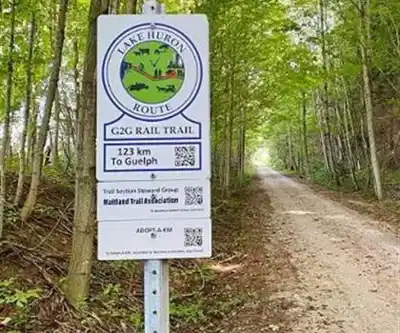
This section forms part of the larger Goderich-to-Guelph Rail Trail network, a long-distance trail system that repurposes former rail lines into accessible multi-use pathways. The Milverton segment captures the essence of that project: a wide, well-maintained surface cutting through working farmland, woodlots, and wetland edges, with the gentle grades that are the hallmark of any trail built on a former rail bed.
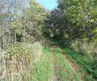
Trail Surface and Terrain
Because the trail follows an old railway corridor, the grades are gradual by design. The 150 meters of elevation gain is distributed across the full 3.2 kilometers rather than concentrated in any single climb, which means you're rarely working hard at any one moment—but you do feel the cumulative effort by the end. The surface alternates between packed gravel and natural earth, which holds up reasonably well in dry conditions. After rain, expect some muddy stretches, particularly in the lower-lying sections near wetland areas, so waterproof footwear is worth considering outside of summer.
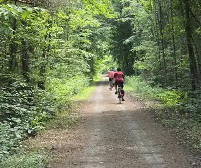
The trail is noticeably wider than most single-track hiking paths, a direct legacy of its railway origins. That width makes it comfortable for groups walking side by side and gives the whole route an open, unhurried feel. There are no technical obstacles—no scrambling, no exposed roots or rocks to navigate—so the focus stays on the landscape rather than your footing.
What You'll See Along the Way
The scenery along this trail is defined by the rhythms of Ontario agriculture. Active farm fields border much of the route, and the views across those fields shift noticeably with the seasons—the pale green of early spring crops, the dense growth of midsummer, and the warm golds and browns that come with harvest. These open agricultural stretches also mean you get long sightlines and a real sense of the flat-to-gently-rolling topography that characterizes this part of the province.
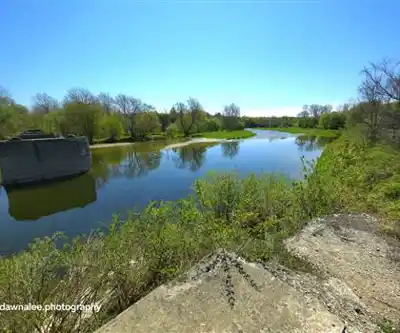
Interspersed with the farmland are woodlot sections that provide shade and a change of pace. These treed areas tend to be where you'll have the best chance of spotting woodland birds and small mammals. The wetland edges along portions of the trail attract waterfowl and support amphibian populations, and they add a layer of ecological variety to what might otherwise be a purely agricultural landscape. Early morning is consistently the best time for wildlife observation, when activity is highest and foot traffic is lowest.
Connection to the G2G Rail Trail Network
The Milverton section doesn't exist in isolation—it connects into the broader Goderich-to-Guelph Rail Trail, which spans a significant distance across southwestern Ontario. For hikers interested in a longer outing, this section can serve as a starting point for exploring adjacent segments of the network. The consistent surface and clear marking that characterize the G2G system make navigation straightforward throughout, and the Milverton segment is no exception.
The trail's position within this network also reflects the historical role of the railway in connecting the small agricultural communities of Huron, Perth, Waterloo, and Wellington counties. The corridor that hikers now walk was once the economic lifeline for farming communities moving grain and goods to market, and that heritage gives the trail a layer of context beyond the scenery itself.
Practical Information
The 3.2-kilometer distance and moderate rating make this trail a solid choice for hikers looking for a meaningful outing without committing to a full day. The 1 hour 25 minute estimate assumes a steady pace with brief stops; many hikers take longer, particularly if they're stopping to take in the farm views or watch for birds. A point-to-point approach works well here, or you can turn around at any point and retrace your steps for a shorter out-and-back.
Bring water and a snack—the moderate elevation gain and open exposure on the agricultural sections mean you'll work up a thirst, especially in warmer months. Sun protection matters in summer given how much of the trail runs through open fields with limited shade. In winter, that same exposure to wind and the potential for snow and ice on the packed gravel surface makes conditions more demanding, so plan accordingly if you're visiting between December and March.
Sturdy footwear with some grip is the right call year-round, and waterproof boots are a practical choice in spring and fall when the natural earth sections can get soft. A camera is worth bringing—the wide-open farm vistas and the quality of light across the fields, particularly in the late afternoon, make for genuinely good photographs at any time of year.
Recommended gear for this trail


Ready to go?
Everything you need to know before you goStarting Point
To access the hiking trails, you can start at several trailheads. One option is to begin at the Milverton trailhead, located near 1 Main Street North, Milverton, Ontario. Another starting point is the G2G Rail Trail parking lot in Goderich, which can be found at 1 Maitland Road North, Goderich, Ontario. Both locations provide convenient access to the trails and have parking facilities available for visitors.
When?
How much?
- Hiking shoes Essential
- → Salomon Elixir Tour Mid WP · 203.38 $
- Layered clothing Essential
- Rain jacket Essential
- Trekking poles
- → Black Diamond Trail Ergo Cork · 69.99 $
- Headlamp
- → Petzl Actik Core 625 · 103.95 $
FAQ - Frequently asked questions
Everything you need to knowThe Essential Hiking Checklist
Everything you need for your next hike. Bilingual, printable, 1 page.
Download the free checklistSimilar hikes nearby
Discover other trails you might enjoy

Health Valley Trail
Huron, Perth, Waterloo and Wellington
Mill Run Trail
Huron, Perth, Waterloo and Wellington
Waterloo Park
Huron, Perth, Waterloo and Wellington
Point Farms Provincial Park
Huron, Perth, Waterloo and Wellington
Breithaupt Park
Huron, Perth, Waterloo and Wellington
Bechtel Park
Huron, Perth, Waterloo and Wellington
Hiking near Kitchener
142 trails to explore ~37 km away
We work hard to provide the most up-to-date and error-free data possible. If something seems incorrect, let us know! Your contribution helps the whole community.
Hikers' opinions