Ready to explore Réservoir Beaudet? Here's everything you need to know before you go!
Discover the trail
Available trails
| Trails | Distance | Elevation | Duration | Difficulty | GPX |
|---|---|---|---|---|---|
| 5.2 km | 0 m | 1h | Beginner |
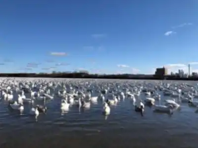
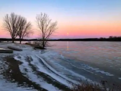
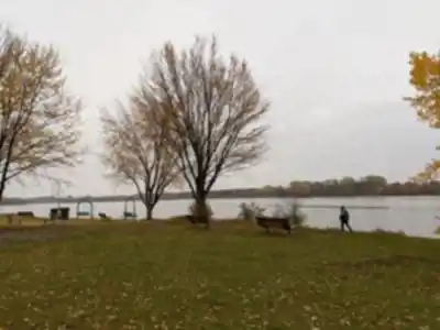
Trail description
Description
Réservoir Beaudet, in Centre-du-Québec, is the kind of place that works for a quick outdoor reset or a full, slow-paced day outside. It’s a peaceful reservoir setting where the main draw is simple: water views, green surroundings, and easy-to-follow trails that let you explore without feeling rushed.
Set in the heart of the region, Réservoir Beaudet feels like a local favorite that’s easy to enjoy whether you’re a regular hiker or just want a calm walk in nature. The overall vibe is quiet and unpretentious—more about being outdoors than chasing big peaks or dramatic elevation.
What you’ll see on the trails
The reservoir itself covers more than 2 square kilometers, so you’re never far from open water views. As you move along the well-maintained trail system, you’ll get changing angles of the shoreline and plenty of chances to pause and look out over the water. The setting is lush and green, and the scenery tends to feel soothing rather than intense—perfect if you’re aiming for a relaxed outing.
Because this is a reservoir landscape, the experience is centered on the contrast between the water and the surrounding vegetation. Expect a walk where the views open up at intervals, and where stopping for a few minutes to watch the water can be just as satisfying as covering distance.
Trail options and difficulty
Réservoir Beaudet offers several hiking trails for different comfort levels, with routes suited to everyone from beginners to more experienced hikers looking to stretch their legs. Trails are clearly marked, which makes it easier to pick a direction and keep moving without needing advanced navigation skills.
If you’re planning your day around a straightforward loop-style outing, the area supports that kind of visit well. One common option is a 5.2 km hike with about 10 m of elevation gain, rated easy. That low elevation change keeps the focus on scenery and time outside rather than physical challenge, and it’s a good fit for a leisurely pace with photo stops.
Even on an easy route, it’s worth taking your time here. The trails naturally invite pauses—whether that’s for a view across the reservoir, a quieter section surrounded by greenery, or a spot where wildlife activity catches your attention.
Terrain and on-trail experience
The trails are described as well maintained, which usually translates into a more comfortable walk and fewer surprises underfoot. You can plan for an outing where the main effort is simply keeping a steady pace and enjoying the surroundings. Because the area is designed to be approachable for a wide range of visitors, it works well for anyone who wants to focus on nature rather than on technical footing.
As you hike, the scenery stays tied closely to the reservoir environment—water, shoreline edges, and the lush greenery framing the views. The overall experience is more “wander and watch” than “push hard,” and it’s easy to build your route around frequent stops.
Wildlife and birdwatching
Réservoir Beaudet is known for its diverse wildlife, and it stands out as a strong choice in Centre-du-Québec if you like pairing a walk with wildlife spotting. Birdwatchers, in particular, will find a lot to enjoy here: the area is home to a wide variety of bird species, and it’s considered an ideal place to observe them in their natural habitat.
Bring binoculars if you have them. With the mix of water and surrounding greenery, you can spend a surprising amount of time scanning and listening, and there’s always the chance you’ll spot something uncommon—rare birds are possible during a visit, especially if you’re patient and keep your eyes moving between the shoreline and the treeline.
Picnic areas and taking a break
One of the easiest ways to make the most of the setting is to plan for a break by the water. There are several designated picnic areas where you can sit down, eat, and enjoy the calm atmosphere. This is a good spot to slow the day down—finish a portion of your hike, have a meal with a view, then decide whether you want to head back onto the trails or simply relax near the reservoir.
Because the outing can be as active or as mellow as you want, the picnic option fits well for a wide range of visitors, including people who prefer shorter walks broken up by rest stops.
Getting there and planning a day trip
Réservoir Beaudet is easily accessible from major cities in Centre-du-Québec, which makes it a practical choice for a day trip. You don’t need to plan an overnight or commit to a long drive to get a rewarding nature experience—this is the kind of place you can visit on a free afternoon or build into a low-stress weekend day.
It also works well for different group types. You can come solo for a quiet walk and some birdwatching time, or bring family and friends for an easy hike followed by a picnic. The combination of clearly marked trails, gentle effort, and plenty of places to pause makes it straightforward to match the day to everyone’s energy level.
What to bring
Comfortable hiking footwear is a smart choice, even on easy trails, especially if you plan to spend a few hours exploring. A small daypack helps for carrying water, snacks, and anything you want for the picnic areas. If wildlife viewing is part of your plan, binoculars are worth packing, and taking a few unhurried minutes at viewpoints can make the birdwatching side of the visit much more rewarding.
Lace up your hiking boots, pack your backpack, and get ready to explore the natural setting around Réservoir Beaudet.
Services and amenities
This information may vary by season.
Ready to go?
Everything you need to know before you goStarting Point
The réservoir beaudet is located in the municipality of Saint-Bonaventure, in the Centre-du-Québec region. To get there, take Highway 20 east from Quebec City and exit at the Saint-Bonaventure exit. Turn left onto Route 132 and drive for about 10 km until you reach the reservoir.
When?
How much?
- Hiking shoes Essential
- Layered clothing Essential
- Rain jacket Essential
- Trekking poles
- Headlamp
FAQ - Frequently asked questions
Everything you need to knowThe Essential Hiking Checklist
Everything you need for your next hike. Bilingual, printable, 1 page.
Download the free checklistSimilar hikes nearby
Discover other trails you might enjoy
Parc Régional De La Rivière Gentilly
Centre-du-Québec
Parc Marie-Victorin
Centre-du-Québec
Mont Gleason
Centre-du-Québec
Sentier des Trotteurs
Centre-du-Québec
Sentier Les Pieds d'Or
Centre-du-Québec
Parc Écologique Godefroy
Centre-du-Québec
Hiking near Sherbrooke
53 trails to explore ~74 km away
We work hard to provide the most up-to-date and error-free data possible. If something seems incorrect, let us know! Your contribution helps the whole community.
Hikers' opinions