

Ready to explore Mont Gleason? Here's everything you need to know before you go!
Discover the trail


Available trails
| Trails | Distance | Elevation | Duration | Difficulty | GPX |
|---|---|---|---|---|---|
| 6.34 km | 320 m | 2h | GPX |
Trail description
Description
Mont Gleason sits in Centre-du-Québec as one of those mountain destinations that manages to feel both accessible and rewarding. At 3.2 kilometers with 416 meters of elevation gain, it's the kind of hike that gives you a real sense of accomplishment without requiring an all-day commitment. The trail is rated as easy, which makes it appealing for a wide range of hikers, but don't let that fool you into thinking it's boring—the climb is steady enough to get your heart rate up, and the views at the top make the effort worthwhile.
The hiking experience
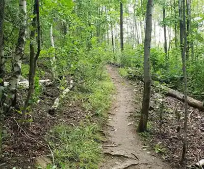
The trail at Mont Gleason follows a straightforward route that takes most people around an hour and a half to complete. You're looking at a consistent upward climb through mixed forest, with the path well-defined and easy to follow. The terrain varies from gentle slopes where you can settle into a comfortable rhythm to steeper sections that require a bit more focus and energy management.
What makes this hike work well for different skill levels is how the elevation gain is distributed. You're not hitting any brutal, leg-burning climbs, but you're definitely working your way upward at a pace that feels purposeful. The trail surface is generally stable, though you'll encounter some rocky sections and root systems that keep things interesting underfoot. It's the kind of hike where you can have a conversation with your hiking partner for most of the way up, but you'll also have moments where you want to focus on your footing and breathing.
The forest canopy provides good shade for most of the route, which makes summer hiking more comfortable and creates a nice sense of being immersed in the woods. As you gain elevation, you'll notice the trees starting to thin out in spots, giving you glimpses of what's waiting at the top and helping build anticipation for the main viewpoint.
Views and payoff
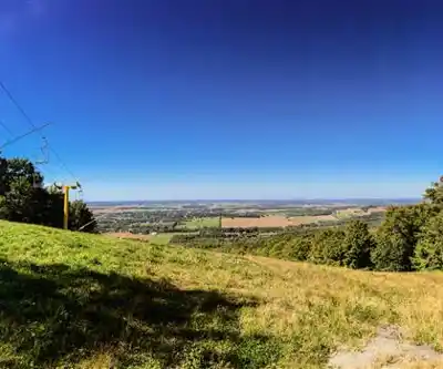
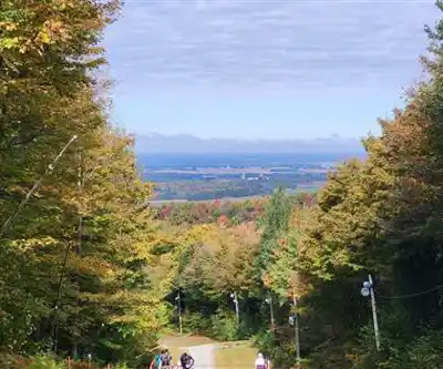
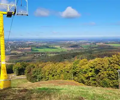
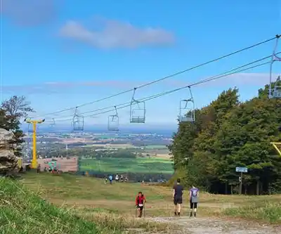
The panoramic views from Mont Gleason are the main draw here, and they deliver on the promise. Once you reach the higher elevations, the landscape opens up to give you sweeping looks across Centre-du-Québec. It's the kind of vista that makes you want to sit down, catch your breath, and really take in the scope of what you're seeing.
These viewpoints work well for photography, but they're equally good for just soaking in the atmosphere. The elevation gives you a genuine sense of being above the surrounding terrain, and on clear days, you can see far enough to get a real appreciation for the geography of the region. It's not just a quick peek through the trees—you're getting the full panoramic experience that makes the climb feel worthwhile.
The contrast between the forested approach and the open views at the top creates a nice progression throughout the hike. You start in the intimate setting of the woods, work your way up through changing perspectives, and finish with that big-picture reward that gives you a completely different sense of the landscape.
Wildlife and natural features
Mont Gleason supports rich biodiversity that adds depth to the hiking experience beyond just the physical challenge and views. The mixed forest environment creates habitat for various bird species, and you'll often hear more wildlife activity than you actually see. It's worth taking your time in quieter sections to listen for birdsong and watch for movement in the canopy.
The plant life changes subtly as you gain elevation, with different species thriving in the varying conditions from the base to the summit. This diversity makes the hike more engaging for anyone interested in natural history, and it's particularly good for hiking with kids who enjoy spotting different types of trees, plants, and signs of animal activity.
The forest feels healthy and vibrant, with good tree cover and understory growth that creates that classic Quebec woodland atmosphere. It's the kind of environment where you feel genuinely immersed in nature rather than just passing through it.
Seasonal considerations
The character of Mont Gleason shifts significantly with the seasons, making it a destination worth revisiting throughout the year. Summer hiking offers the full forest experience with lush greenery and active wildlife, while fall transforms the mountain into a showcase for autumn foliage. The elevation gain means you get to experience the color changes from multiple perspectives as you climb.
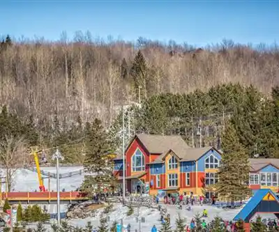
Winter brings a completely different set of opportunities, with the mountain serving as a skiing and snowboarding destination. This year-round versatility means you can think of Mont Gleason as a place to return to rather than a one-time visit, with each season offering its own distinct experience and appeal.
Spring can be particularly rewarding as the forest comes back to life, though trail conditions may vary depending on snowmelt and recent weather. Summer and fall tend to offer the most predictable hiking conditions.
Amenities and comfort features
One of the practical advantages of Mont Gleason is the presence of picnic areas and rest spots that support a more relaxed approach to your outdoor time. These facilities make it easy to extend your visit beyond just the hike itself, turning the outing into a longer, more social experience if that's what you're looking for.
The rest areas are well-positioned for taking breaks during the climb or for settling in at the top to enjoy your lunch with a view. This setup makes the mountain particularly family-friendly and good for groups with mixed hiking abilities, since faster hikers can wait comfortably while others catch up.
The overall atmosphere is described as serene, which fits with the idea of using this as an escape from daily routines and urban noise. The combination of natural setting and thoughtful amenities creates an environment where you can genuinely relax and recharge.
Planning your visit
For the 3.2-kilometer route with its 416 meters of elevation gain, plan on about an hour and a half for the complete hike, though you'll want to add time if you're planning to spend time at the viewpoints or rest areas. The easy rating makes this accessible for most fitness levels, but the steady climb means you should still come prepared with water and appropriate footwear.
Layer your clothing to account for temperature differences between the base and summit, especially during shoulder seasons. The elevation gain is enough to create noticeable changes in conditions, and the open viewpoints can be windier and cooler than the protected forest sections.
Consider bringing snacks or a light lunch to take advantage of the picnic areas and rest spots. The setup here encourages taking your time rather than rushing through, and having food along makes it easier to turn the hike into a more complete outdoor experience.
Recommended gear for this trail


Ready to go?
Everything you need to know before you goWhen?
How much?
- Hiking shoes Essential
- → Salomon Elixir Tour Mid WP · 203.38 $
- Layered clothing Essential
- Rain jacket Essential
- Trekking poles
- → Black Diamond Trail Ergo Cork · 69.99 $
- Headlamp
- → Petzl Actik Core 625 · 103.95 $
FAQ - Frequently asked questions
Everything you need to knowThe Essential Hiking Checklist
Everything you need for your next hike. Bilingual, printable, 1 page.
Download the free checklistSimilar hikes nearby
Discover other trails you might enjoy

Réservoir Beaudet
Centre-du-Québec

Parc Régional De La Rivière Gentilly
Centre-du-Québec

Parc Marie-Victorin
Centre-du-Québec

Sentier des Trotteurs
Centre-du-Québec

Sentier Les Pieds d'Or
Centre-du-Québec

Parc Écologique Godefroy
Centre-du-Québec
Hiking near Sherbrooke
53 trails to explore ~59 km away
We work hard to provide the most up-to-date and error-free data possible. If something seems incorrect, let us know! Your contribution helps the whole community.
Hikers' opinions