

Ready to explore Sentier des Trotteurs? Here's everything you need to know before you go!
Discover the trail


Available trails
| Trails | Distance | Elevation | Duration | Difficulty | GPX |
|---|---|---|---|---|---|
| 1 km | 0 m | 15min | Beginner | ||
| 3.4 km | 0 m | 45min | Beginner | ||
| 6 km | 90 m | 1h30 | Beginner | ||
| 2.4 km | 0 m | 32min | Beginner | ||
| 6 km | 0 m | 1h30 | Intermediate | ||
| 9.5 km | 250 m | 2h30 | Advanced | ||
| 8.5 km | 0 m | 2h | Advanced | ||
| 26 km | 0 m | 6h | Advanced |
Trail description
Description
Sentier des Trotteurs is a lesser-known hiking option in Centre-du-Québec that works well when you want a quiet day (or more than one day) outside without a lot of logistics. It’s described as a serene escape, and that’s exactly the vibe to expect: a natural corridor that lets you settle into a steady rhythm, with plenty of small, satisfying details along the way.
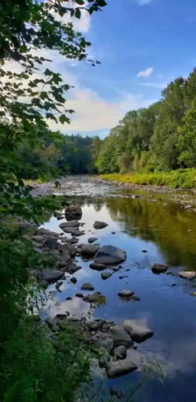
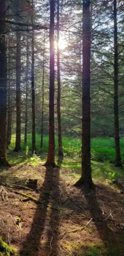
The trail moves through lush forest, tracks alongside babbling brooks, and rolls over gentle hills. The overall experience is more about being immersed in a green landscape than chasing big dramatic features. If you enjoy walking in the shade, listening to water, and watching the terrain subtly change as you go, this trail delivers that kind of day in the woods.
What the trail is like
On the ground, the Sentier des Trotteurs “meanders,” which is a good hint at how it feels: not a straight shot, but a route that keeps you engaged as it winds through the landscape. Expect the character of the hike to shift between three main elements:
-
Forest walking: The core of the trail is set in dense, leafy forest, giving you a calm, sheltered feel for much of the route. This is the kind of terrain where you’ll want to slow down a bit, look for small details, and enjoy the quiet.
-
Water-side stretches: The trail runs alongside brooks at points, adding a steady sound of moving water. These sections tend to feel cooler and more relaxing, and they’re also where you’ll want to watch your footing if the ground is damp.
-
Gentle hills: Rather than steep climbs, the ups and downs are described as gentle. That makes it approachable for newer hikers while still giving experienced hikers enough variation to keep things interesting.
Because this trail is billed as suitable for hikers of all levels, it’s a good fit if you’re easing into hiking, bringing along someone who prefers moderate terrain, or simply looking for a mellow route where the point is the scenery and the time outside.
Scenery and viewpoints
One of the standout features mentioned for the Sentier des Trotteurs is its scenic views. As you move through Centre-du-Québec’s varied landscape, you’ll come across vistas that show off the region’s diversity—forest, open looks across the terrain, and the kinds of natural viewpoints that make you stop for a minute and take it in.
If you like taking photos, bring your camera or make sure your phone is charged. The views are noted as especially photo-friendly, and it’s the kind of trail where the scenery changes enough that you’ll likely want to capture more than one spot.
Plants, wildlife, and what to watch for
This trail is also a strong pick if you enjoy the quieter side of hiking—paying attention to what’s growing and moving around you. The Sentier des Trotteurs is home to local wildlife and vibrant plant life, which makes it appealing for nature enthusiasts and photographers.
A few practical ways to get more out of that side of the hike:
-
Slow down in the forest sections: When the trail feels calm and enclosed, it’s easier to notice movement and color—birds flitting between branches, small animals crossing the path, or seasonal changes in leaves and undergrowth.
-
Pause near the brooks: Water tends to bring more activity. Take a minute to stand quietly and scan the area before moving on.
-
Stay alert without being loud: If you’re hoping to see wildlife, keep your conversations low and your movements steady. You’ll often spot more when you’re not rushing.
Navigation and trail conditions
A major practical advantage here is that the Sentier des Trotteurs is well-marked and maintained. Clear signage and easy-to-follow routes make it straightforward to navigate, which is especially helpful if you’re newer to hiking or you simply want a low-stress outing where you can focus on your surroundings instead of constantly checking your route.
Even on well-marked trails, it’s still smart to pay attention at intersections and confirm you’re staying on the intended path. But the general expectation here is a route that supports a smooth, confident hike with fewer “where am I?” moments.
Distance, elevation, and difficulty
The Sentier des Trotteurs is listed at 61.8 km with about 250 m of elevation gain, and it’s rated easy. That combination points to a long trail that stays relatively gentle overall—more about steady movement and endurance than steep climbing.
If you’re planning a visit, think about how you want to experience it. Some hikers will prefer shorter out-and-back portions or a section that fits their time and energy, while others may want to treat it as a longer route to explore at a relaxed pace. The gentle hills and easier rating suggest you can focus on enjoying the landscape rather than bracing for tough climbs.
How to prepare for a good day on the Sentier des Trotteurs
A little planning goes a long way, especially on a trail that can keep you out for a while. These are the key prep steps highlighted for this hike:
-
Check the weather before you go: Conditions can change quickly, and being prepared makes the hike more comfortable and safer. Look at the forecast before you leave so you can dress and pack accordingly.
-
Pack the essentials: Bring plenty of water and snacks so you can stay energized. Add sunscreen for exposed sections and insect repellent for forest and water-adjacent areas where bugs can be more noticeable.
-
Wear proper footwear: A good pair of hiking shoes will make the biggest difference in comfort and confidence, especially when the ground is uneven, damp near brooks, or rolling through gentle hills.
Trail etiquette and protecting the experience
The Sentier des Trotteurs is described as a peaceful, natural escape, and good trail habits help keep it that way. The core guideline here is simple: leave no trace. Pack out anything you bring in, and respect the natural environment so others can enjoy the same quiet, scenic experience in the future.
That also means staying on the marked route, being mindful around wildlife, and keeping the trail clean and undisturbed as you hike through Centre-du-Québec’s forests and waterways.
Who this trail suits
This trail is positioned as a good fit for a wide range of visitors. It works for seasoned hikers who want a calmer route with scenery and nature observation, and it’s also welcoming for people just starting out thanks to the well-maintained, well-marked paths and gentle terrain.
It’s also described as a solid choice for a peaceful solo hike or an outing with friends or family, especially if your group prefers a nature-focused walk with a mix of forest, water, and viewpoints rather than a steep, technical challenge.
Services and amenities
This information may vary by season.
Recommended gear for this trail


Ready to go?
Everything you need to know before you goStarting Point
The trailhead for the Trotters' Trail is located at the entrance to the village of Saint-Étienne-des-Grès, on Route 158.
When?
How much?
- Hiking shoes Essential
- → Salomon Elixir Tour Mid WP · 203.38 $
- Layered clothing Essential
- Rain jacket Essential
- Trekking poles
- → Black Diamond Trail Ergo Cork · 69.99 $
- Headlamp
- → Petzl Actik Core 625 · 103.95 $
FAQ - Frequently asked questions
Everything you need to knowThe Essential Hiking Checklist
Everything you need for your next hike. Bilingual, printable, 1 page.
Download the free checklistSimilar hikes nearby
Discover other trails you might enjoy

Réservoir Beaudet
Centre-du-Québec

Parc Régional De La Rivière Gentilly
Centre-du-Québec

Parc Marie-Victorin
Centre-du-Québec

Gleason
Centre-du-Québec

Sentier Les Pieds d'Or
Centre-du-Québec

Parc Écologique Godefroy
Centre-du-Québec
Hiking near Sherbrooke
53 trails to explore ~73 km away
We work hard to provide the most up-to-date and error-free data possible. If something seems incorrect, let us know! Your contribution helps the whole community.
Hikers' opinions