

Ready to explore Drumheller Hoodoos Trail? Here's everything you need to know before you go!
Discover the trail
Available trails
| Trails | Distance | Elevation | Duration | Difficulty | GPX |
|---|---|---|---|---|---|
| 0.2 km | 7 m | 15min | Beginner | GPX |
Trail description
Description
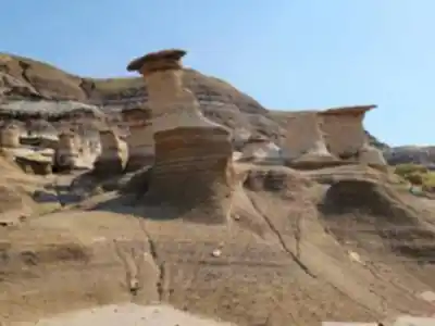
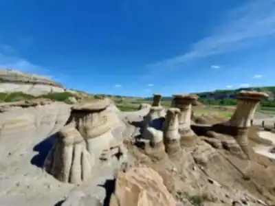
The Drumheller Hoodoos Trail is one of the most accessible ways to get up close with the geological wonders that define Alberta's Canadian Badlands. Located along Highway 10, this short trail puts you face to face with some of the region's most striking hoodoo formations — those tall, narrow rock spires that erosion has been quietly sculpting for thousands of years. At just 0.2 km with only 7 metres of elevation gain, the hike itself takes about 15 minutes, but most visitors end up lingering far longer than that.
The Hoodoos Up Close
Hoodoos form when softer sedimentary rock erodes away beneath a harder caprock layer. That harder cap protects the column beneath it while everything around it gradually washes and weathers away, leaving behind these distinctive pillars. The formations along this trail are excellent examples of the process — varied in height, shape, and texture, with the reddish-brown layering in the rock telling the story of ancient river deposits laid down long before this landscape looked anything like it does today.
Walking among them gives you a sense of scale that photos don't quite capture. Some of the spires rise several metres above the trail, and the way the light hits the sedimentary banding throughout the day changes the whole character of the place. Early morning and late afternoon tend to bring out the warmest tones in the rock, which makes a real difference if photography is part of your plan.
Trail Experience and Terrain
The trail is genuinely easy — flat with only the gentlest of inclines, well-defined underfoot, and simple to navigate. The surface is typical badlands terrain: packed earth mixed with loose sediment that can get dusty in dry weather. There's nothing technical about the route, and the short distance means you're spending the vast majority of your time actually looking at the formations rather than covering ground.
That's kind of the point here. This isn't a trail where the journey is the destination — the hoodoos themselves are the whole show, and the trail is simply the vehicle that gets you into the middle of them. You can move through the whole thing in 15 minutes if you want, or you can slow down, walk around individual formations, and spend time noticing the details in the rock layers. Most people land somewhere in between.
The terrain is exposed, with minimal shade, so sun protection and water matter more than the short distance might suggest — especially on hot summer days when the badlands can feel significantly warmer than surrounding areas.
Location and Access
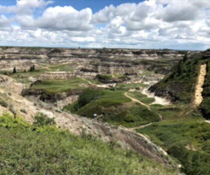
The trailhead sits along Alberta Provincial Highway 10, which runs southeast from downtown Drumheller along the Red Deer River. This stretch of highway is part of the broader Hoo Doo Trail scenic drive, and the hoodoo formations are visible from the road itself — you won't have any trouble spotting where to pull off. Parking is available directly at the site, and the transition from car to trail is immediate.
The highway passes through the historic community of Rosedale before continuing through East Coulee, and the entire route falls within the boundaries of the Town of Drumheller — a result of the 1998 amalgamation between the former City of Drumheller and the Municipal District of Badlands No. 7. In practical terms, this means consistent signage and maintenance along the route.
Who This Trail Works Well For
Families with young kids will find this one of the better stops in the Drumheller area — the flat terrain is stroller-friendly, the formations are genuinely interesting to children, and there's no risk of the hike becoming a slog before you've even reached the good part. The educational angle is real too: seeing erosion at work in such a visible, dramatic way tends to spark questions and conversations that stick with kids.
Photographers will appreciate the multiple vantage points the trail offers, from tight detail shots of the rock textures and layering to wider compositions that frame the hoodoos against the open prairie sky. The relatively compact area means you can experiment with angles without covering a lot of ground.
For anyone doing a broader exploration of the Canadian Badlands, this trail fits naturally into a day that might also include the Royal Tyrrell Museum, the Horseshoe Canyon viewpoint, or a drive along the full Hoo Doo Trail scenic route. It's a self-contained stop that adds real visual and geological context to the region without demanding much time or effort.
A Few Things to Keep in Mind
- Sun exposure: The trail is fully exposed. Sunscreen, a hat, and water are worth bringing even for a 15-minute walk.
- Wind: The open badlands landscape means wind can pick up, which affects both comfort and photography.
- Dust: In dry conditions, the sediment underfoot can be loose and dusty — closed-toe shoes are a better call than sandals.
- Timing: The light is best in the early morning or late afternoon for photography, when the warm tones in the rock really come through.
The Drumheller Hoodoos Trail delivers one of the most visually distinctive experiences in the Canadian Badlands in a format that's accessible to virtually everyone — and that combination is genuinely hard to beat.
Recommended gear for this trail


Ready to go?
Everything you need to know before you goStarting Point
The Hoodoos Trail is located in the badlands of Alberta, Canada. The easiest way to get there is to take Highway 9 from Drumheller, AB and turn onto Hoodoos Trail Road.
When?
How much?
- Hiking shoes Essential
- → Salomon Elixir Tour Mid WP · 203.38 $
- Layered clothing Essential
- Rain jacket Essential
- Trekking poles
- → Black Diamond Trail Ergo Cork · 69.99 $
- Headlamp
- → Petzl Actik Core 625 · 103.95 $
FAQ - Frequently asked questions
Everything you need to knowThe Essential Hiking Checklist
Everything you need for your next hike. Bilingual, printable, 1 page.
Download the free checklistSimilar hikes nearby
Discover other trails you might enjoy

Horsethief Canyon
Canadian Badlands
Writing-on-Stone Provincial Park
Canadian Badlands
Dinosaur Provincial Park
Canadian Badlands
Horseshoe Canyon
Canadian Badlands
Hiking near Airdrie
90 trails to explore ~104 km away
We work hard to provide the most up-to-date and error-free data possible. If something seems incorrect, let us know! Your contribution helps the whole community.
Hikers' opinions