Hiking Goat Mountain - panoramic view  mountain outdoor sky snow nature glacier cloud hill massif mountain range rocky hillside ridge summit overlooking ravine distance tree plant
--°C
Loading...
See forecast →

Hiking in Goat Mountain: trails, map and practical info

Vancouver Coast Mountains • British Columbia

4.7 Appreciated by 25 hikers
François Dumaine
By François DumaineContributor since 2013Updated 19/06/2026
Difficulty
Easy
Distance
16 km
Elevation
2,696 m
Duration
5h30
Max altitude
1,401 m

Tackle this 16 km summit hike in the Vancouver Coast Mountains near Pemberton, BC—a 5h30 adventure with panoramic views stretching from Howe Sound to Vancouver's skyline. The rocky alpine terrain and diverse ecosystems make this challenging day hike a rewarding escape from the city.

Recommended for :
Beginners

Ready to explore Goat Mountain? Here's everything you need to know before you go!

Discover the trail

6 community photos

Trail description

{
"opening_paragraph": "

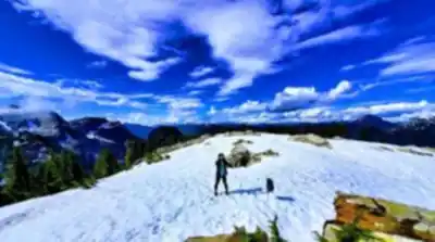
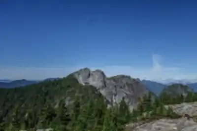
Goat Mountain rises prominently in the Vancouver Coast Mountains just north of Vancouver, offering one of the most rewarding day hikes accessible from the city. This peak delivers a genuine alpine experience—challenging terrain, diverse ecosystems, and summit views that stretch from Howe Sound to Vancouver's skyline. The mountain is located in North Vancouver, with the trailhead conveniently located at Grouse Mountain Resort, which means no forest service road approach and no four-wheel drive required.

",
"trail_section": "

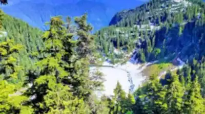
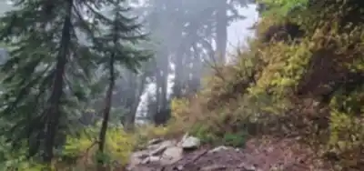
The route covers 16 kilometers with 2,696 meters of elevation gain—numbers that tell you this hike demands serious preparation and fitness. Plan for around 5.5 hours on the trail. The path starts at Grouse Mountain Resort and immediately pulls you into dense coastal forest, where Douglas firs and western red cedars form a thick canopy overhead. The forest floor stays cool and damp even on warm summer days, with soft earth underfoot and the rich scent of cedar in the air.

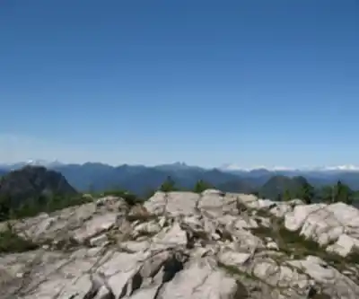
As you gain elevation, the character of the hike shifts noticeably. The lush lower forest gives way to rockier, more exposed terrain where the trail demands careful foot placement. This is a steep, demanding route with narrow sections that require focus. Brief openings in the canopy start revealing distant peaks and hint at what's waiting above. The final approach to the summit involves navigating rocky sections that can be genuinely slippery when wet—this is where the hike earns its challenging reputation. The trail becomes less defined up top, so basic route-finding confidence is useful here.

"
}

Recommended gear for this trail

LGPO Pick
Elixir Tour Mid WP
Salomon
Elixir Tour Mid WP
4.5 (2847 reviews)
Waterproof mid-height boot ideal for rocky terrain
203.38 $
See price
Daylite Plus 20L
Osprey
Daylite Plus 20L
4.7 (3215 reviews)
Lightweight and versatile for day hikes
109.99 $
See price
Most Popular
Wide Mouth 1L
Nalgene
Wide Mouth 1L
4.8 (12540 reviews)
Unbreakable and BPA-free — a hiking essential
23.11 $
See price
Best Value
Trail Ergo Cork
Black Diamond
Trail Ergo Cork
4.4 (1456 reviews)
Comfortable cork grip for long ascents
69.99 $
See price
Actik Core 625
Petzl
Actik Core 625
4.6 (1893 reviews)
USB rechargeable with 600 lumens for early starts
103.95 $
See price
Affiliate links — LGPO may earn a commission at no extra cost to you.

Ready to go?

Everything you need to know before you go

Where?

Address
Not available
GPS coordinates
49.40358639999999, -123.0790696
Phone
Not available

Starting Point

The goat mountain trails are located in the community of Pemberton, British Columbia. To get to the start of the trails, take Highway 99 north from Vancouver and exit at Pemberton Meadows Road. Follow Pemberton Meadows Road for about 15 minutes until you reach the signed trailhead parking lot on the left.

When?

Opening hours
From sunrise to sunset
Varies by season
Best season
Fall
Spectacular colors
Best time
Early morning
Less crowded
Weather (next days)
Loading

How much?

Entry fees
Adult
Not available
Child
What to bring?
Gear
Download the PDF checklist
Water & food
2L minimum
No water point on the trail
Bring energy snacks for a 4h+ hike
Good to know
Park rules
No dogs
Safety
Download the GPX before you go
Limited cellular coverage on the trail
Slippery after rain
Be careful on rocky sections
In an emergency
Emergency
911
Parking GPS
49.40358639999999, -123.0790696
Center
Not available

Hikers' opinions

4.7
10 Reviews
RH
Robert H.
Mar 5, 2024
Photography opportunities are endless here. Golden hour lighting on the peaks is magical. The drive up Pemberton Meadows Road sets the tone perfectly. Only downside is the paid parking situation, but understandable given trail maintenance needs.
MT
Marcus T.
Feb 15, 2024
The trail conditions were challenging in winter with snow patches, but the alpine scenery near Pemberton is absolutely stunning. Make sure to bring proper gear as weather changes quickly at elevation. The parking fees are worth it for this quality of mountain access.
SK
Sarah K.
Jan 28, 2024
Started early morning to avoid crowds. The elevation gain is no joke - definitely felt those 2696 meters! Trail markers could be clearer in some sections. Recommend checking conditions before heading up as fog can roll in unexpectedly in the Coast Mountains.
DR
David R.
Sep 12, 2023
Perfect fall colors when we visited! The birch and maple trees were spectacular. Saw several mountain goats in the distance which was incredible. Trail surface varies from rocky to soft earth - good hiking boots essential.
JM
Jennifer M.
Jul 20, 2023
Great workout for experienced hikers! The no-dogs policy keeps wildlife encounters more natural. Wildflower meadows were in full bloom during summer. Pack extra water as there aren't many reliable sources along the route.

FAQ - Frequently asked questions

Everything you need to know
Easy
2696.00 M
1401.00 M
5h30
No
No
While Goat Mountain is rated as Easy difficulty, the significant 2696m elevation gain means beginners should be in good physical condition before attempting this hike. The trail itself is well-maintained and straightforward to follow, making it accessible for those with basic hiking experience.
Didn't find your answer?
Free 1 pages

The Essential Hiking Checklist

Everything you need for your next hike. Bilingual, printable, 1 page.

Download the free checklist
Top 10 best hiking in Vancouver Coast Mountains
Our ranking based on hiker reviews

Hiking near Vancouver

235 trails to explore ~14 km away

View trails
Did you spot an error?

We work hard to provide the most up-to-date and error-free data possible. If something seems incorrect, let us know!

Update : June 2026