

Ready to explore Alouette Mountain? Here's everything you need to know before you go!
Discover the trail


Trail description
Description
Alouette Mountain stands as one of the most rewarding hiking destinations in the Vancouver Coast Mountains, offering a challenging adventure that showcases the raw beauty of British Columbia's coastal wilderness. Located within Golden Ears Provincial Park, this prominent peak rises to 1,371 meters (4,498 feet) and provides hikers with an authentic mountain experience just a short drive from Vancouver.
The Trail Experience
The Alouette Mountain Trail presents a demanding 16-kilometer round trip journey with 1,100 meters of elevation gain that will test your endurance while rewarding your efforts with spectacular scenery. Plan for about 6.5 hours on the trail – this isn't a casual day hike, and the sustained climbing will challenge even experienced hikers.
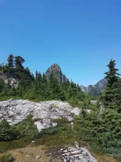
The trail starts by winding through dense coastal forest where towering Douglas firs and western red cedars create a cathedral-like canopy overhead. The initial sections follow alongside serene streams, where the sound of flowing water accompanies your steady climb. As you gain elevation, the forest character gradually changes, and you'll notice the transition from the lush lower elevations to the more rugged terrain of the upper mountain.
The path becomes increasingly steep as you approach the higher elevations, demanding careful footing and steady pacing. Rocky sections and root-covered terrain require attention, especially during wet conditions when surfaces can become slippery. The trail is well-established but can be muddy and challenging in places, particularly during the shoulder seasons. Expect your legs to feel the burn as the grade intensifies – the relentless upward trajectory is what earns this hike its hard difficulty rating.
Natural Environment and Wildlife
Alouette Mountain showcases the rich biodiversity that makes the Vancouver Coast Mountains so remarkable. The varied elevation zones create distinct ecosystems, each supporting different plant and animal communities. In the lower forest sections, vibrant wildflowers add splashes of color along the trail during spring and summer months, creating natural gardens that contrast beautifully with the deep green of the surrounding conifers.
Wildlife encounters are a real possibility on this trail. Black bears inhabit the area, so proper food storage and bear awareness are essential. Deer are commonly spotted, particularly in the early morning or late afternoon hours. The diverse bird population includes various species adapted to both the dense forest and more open alpine areas near the summit.
The forest ecosystem here represents classic Pacific Northwest temperate rainforest, with its characteristic moss-covered trees, ferns carpeting the forest floor, and the distinctive smell of rich, damp earth. This environment creates a sense of wilderness immersion that's increasingly rare so close to major urban centers. The thick canopy provides welcome shade during the climb, though you'll appreciate any breeze that filters through as you work your way upward.
Summit Views and Rewards
The summit of Alouette Mountain delivers panoramic views that justify every challenging step of the ascent. From the 1,371-meter peak, you'll look out over the surrounding Vancouver Coast Mountains, with their dramatic peaks and deep valleys stretching in all directions. The perspective provides an excellent understanding of the region's mountainous geography and the scale of the wilderness that surrounds the Lower Mainland.
On clear days, the views extend far beyond the immediate mountain ranges. Vancouver's skyline becomes visible in the distance, creating a striking contrast between urban development and pristine wilderness. This visual connection between city and mountains emphasizes why the Vancouver area is considered one of the world's most dramatically situated metropolitan regions.
The summit area offers multiple vantage points for photography and rest breaks. The exposed rocky areas provide stable platforms for taking in the scenery, though weather conditions can change rapidly at this elevation. Wind and temperature variations are common, making appropriate clothing essential even on seemingly mild days at the trailhead. Take time to savor the accomplishment – you've earned these views through serious effort.
Trail Preparation and Planning
Success on Alouette Mountain requires thorough preparation and realistic assessment of your hiking abilities. The combination of distance and elevation gain makes this a strenuous undertaking that demands good physical conditioning. Start early to ensure adequate daylight for the return journey, especially since tired legs move slower on the descent.
Water requirements are substantial – carry more than you think you'll need, as the sustained climbing increases consumption significantly. Energy-rich snacks and a substantial lunch are essential for maintaining strength throughout the day. The trail offers limited natural water sources that require purification, so carrying sufficient clean water is the safest approach.
Weather conditions can change dramatically between the trailhead and summit, so layered clothing is crucial. Even on warm valley days, the summit can be cold and windy. Rain gear is advisable year-round, as coastal weather patterns can bring sudden precipitation. Sturdy hiking boots with good ankle support are essential given the rocky and root-covered terrain that becomes more technical as you climb higher.
Safety and Navigation
Cell phone service becomes limited or non-existent in many areas along the trail, making it important to inform someone of your hiking plans before departure. Carry a map and compass or GPS device as backup navigation, and consider bringing a whistle for emergency signaling.
The trail's challenging nature means it's not suitable for inexperienced hikers or those unprepared for a demanding mountain environment. However, for those ready to tackle a serious hiking challenge, Alouette Mountain provides an authentic wilderness experience that showcases the best of the Vancouver Coast Mountains' natural beauty and rugged character.
Recommended gear for this trail


Ready to go?
Everything you need to know before you goStarting Point
The start of the trails at the alouette mountain can be accessed by travelling east on the Trans-Canada Highway to exit #122. From there, take the Alouette Lake Road for approximately 15 km until you reach the parking lot for the mountain.
When?
How much?
- Hiking shoes Essential
- → Salomon Elixir Tour Mid WP · 203.38 $
- Layered clothing Essential
- Rain jacket Essential
- Trekking poles
- → Black Diamond Trail Ergo Cork · 69.99 $
- Headlamp
- → Petzl Actik Core 625 · 103.95 $
FAQ - Frequently asked questions
Everything you need to knowThe Essential Hiking Checklist
Everything you need for your next hike. Bilingual, printable, 1 page.
Download the free checklistSimilar hikes nearby
Discover other trails you might enjoy

Bridle Path
Vancouver Coast Mountains
Flora Lake
Vancouver Coast Mountains

Williamson Lake
Vancouver Coast Mountains
Brandywine Mountain
Vancouver Coast Mountains

Coliseum Mountain
Vancouver Coast Mountains
Goose Lake
Vancouver Coast Mountains
Hiking near Vancouver
235 trails to explore ~46 km away
We work hard to provide the most up-to-date and error-free data possible. If something seems incorrect, let us know! Your contribution helps the whole community.
Hikers' opinions