

Ready to explore Coliseum Mountain? Here's everything you need to know before you go!
Discover the trail

Trail description
Description
Coliseum Mountain stands as one of the more demanding peaks in the Vancouver Coast Mountains, offering experienced hikers a full-day challenge through pristine wilderness. Located beyond the popular trails of Lynn Headwaters Regional Park, this mountain requires serious commitment but delivers some of the most spectacular panoramic views in the region.
The Trail Experience
Starting from Lynn Headwaters Regional Park, the route to Coliseum Mountain covers approximately 24 kilometers round trip with a substantial 1,440 meters of elevation gain. This is definitively a difficult trail that demands respect and proper preparation. The journey begins on well-maintained park trails before transitioning into more rugged backcountry terrain that will test your navigation skills and physical endurance.
The initial section winds through the lush temperate rainforest that defines this region. You'll cross several bubbling creeks that provide natural rest stops and water refill opportunities, though you should always treat backcountry water sources. As you gain elevation, the forest composition shifts, and the terrain becomes increasingly challenging with steep ascents over rocky sections and root-laden paths.
The middle portion of the hike presents the most technical challenges. Expect to scramble over boulders and navigate through areas where the trail becomes less defined. This is where the "difficult" rating truly applies – you'll need solid hiking experience and confidence in route-finding. The forest canopy of towering Douglas firs and western red cedars provides welcome shade during the steeper climbs, but also creates a cathedral-like atmosphere that makes the physical effort feel almost meditative.
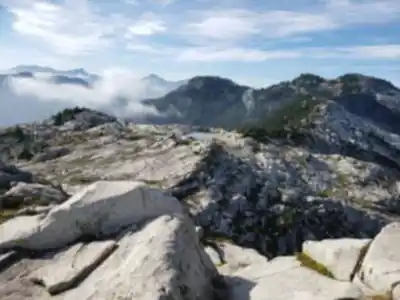
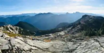
As you push through the upper elevations, the character of the landscape transforms dramatically. The dense forest gives way to more open terrain where you can finally catch glimpses of the surrounding peaks. This transition zone offers some of the most rewarding moments of the climb, as each step higher reveals more of the Coast Mountains' dramatic topography stretching endlessly in all directions.
Wildlife and Natural Features
The diverse ecosystem along the Coliseum Mountain trail supports an impressive array of wildlife. Black bears are present throughout this region, so proper food storage and bear awareness are essential. Deer frequently browse in the meadow areas, and you might spot them during early morning or late afternoon hikes. The bird life is particularly rich, with everything from small songbirds in the understory to larger raptors soaring above the treeline.
During spring and summer months, the trail comes alive with wildflowers, particularly in the higher elevation meadows. These colorful displays provide a striking contrast to the deep greens of the forest and add photographic opportunities throughout the climb. The plant diversity reflects the elevation changes you'll experience, from coastal rainforest species at the base to alpine varieties near the summit.
The geological features along this route tell the story of the Coast Mountains' formation. Exposed rock faces reveal the complex history of glacial activity that shaped these peaks, while the numerous creek crossings showcase the ongoing erosive forces that continue to carve these valleys. Each season brings different water levels and crossing conditions, adding another variable to consider in your planning.
Summit Rewards
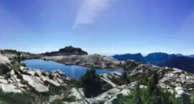
Reaching the summit of Coliseum Mountain delivers views that justify every challenging step of the ascent. The panoramic vistas stretch across the entire Vancouver Coast Mountains range, offering a perspective that few hikers ever experience. On clear days, the view extends south to Mount Baker in Washington State, while glimpses of Vancouver Island appear to the west. The urban sprawl of Vancouver becomes a distant memory as you're surrounded by peak after peak of pristine wilderness.
The summit itself provides ample space to rest, eat, and soak in the accomplishment. The 360-degree views mean you can spend considerable time identifying different peaks and valleys, making this an ideal spot for photography enthusiasts. The sense of isolation and achievement at the top creates a profound connection with the Coast Mountains that's difficult to replicate on more accessible peaks.
Weather conditions at the summit can be dramatically different from those at the trailhead. Even on warm days below, the exposed summit can be windy and significantly cooler. This elevation also means you're more likely to encounter cloud cover or sudden weather changes that can dramatically alter visibility and conditions.
Planning and Preparation
This hike demands thorough preparation and should only be attempted by experienced hikers in good physical condition. Plan for a full day on the trail – most hikers require 8-10 hours to complete the round trip. Start early to ensure you have plenty of daylight, especially during shorter winter days when this trail becomes significantly more challenging due to snow and ice conditions.
Water is crucial for this long, strenuous hike. Carry at least 3-4 liters per person, along with substantial food for energy throughout the day. The elevation gain and distance mean your body will be working hard for hours. Pack layers for changing weather conditions, as temperatures can vary dramatically between the trailhead and summit.
Navigation skills are important for this trail, particularly in the upper sections where the route becomes less obvious. A GPS device or smartphone with offline maps provides valuable backup to traditional map and compass navigation. Weather can change rapidly in the Coast Mountains, so check current conditions and forecasts before departing.
Emergency preparedness takes on added importance given the remote nature and technical difficulty of this route. Inform someone of your planned route and expected return time. Consider carrying emergency shelter and first aid supplies appropriate for backcountry conditions. Cell phone coverage is spotty to non-existent throughout most of the route.
Access and Logistics
Lynn Headwaters Regional Park serves as the gateway to Coliseum Mountain, providing parking and basic facilities at the trailhead. The park can fill up quickly on weekends, so arriving early serves the dual purpose of securing parking and getting an early start on your long hike. The park has restroom facilities and information boards that provide current trail conditions and safety reminders.
Leave no trace principles are particularly important in this pristine wilderness area. Pack out all trash, stay on established trails where they exist, and respect the natural environment that makes this hike so special. The remote nature of much of this trail means that any impact you create will be visible to future hikers for a long time.
Trail conditions can vary significantly with seasons and recent weather. Check recent trip reports and consider contacting local hiking groups for current information about trail conditions, especially regarding creek crossings and upper elevation snow conditions that can persist well into summer months.
Recommended gear for this trail


Ready to go?
Everything you need to know before you goStarting Point
The coliseum mountain trails start at the coliseum mountain parking lot, which is located off of Highway 99, about 15 minutes north of Squamish.
When?
How much?
- Hiking shoes Essential
- → Salomon Elixir Tour Mid WP · 203.38 $
- Layered clothing Essential
- Rain jacket Essential
- Trekking poles
- → Black Diamond Trail Ergo Cork · 69.99 $
- Headlamp
- → Petzl Actik Core 625 · 103.95 $
FAQ - Frequently asked questions
Everything you need to knowThe Essential Hiking Checklist
Everything you need for your next hike. Bilingual, printable, 1 page.
Download the free checklistSimilar hikes nearby
Discover other trails you might enjoy

Bridle Path
Vancouver Coast Mountains
Flora Lake
Vancouver Coast Mountains

Alouette Mountain
Vancouver Coast Mountains

Williamson Lake
Vancouver Coast Mountains
Brandywine Mountain
Vancouver Coast Mountains
Goose Lake
Vancouver Coast Mountains
Hiking near Vancouver
235 trails to explore ~19 km away
We work hard to provide the most up-to-date and error-free data possible. If something seems incorrect, let us know! Your contribution helps the whole community.
Hikers' opinions