

Ready to explore Mount Seymour? Here's everything you need to know before you go!
Discover the trail
Trail description
Description
Mount Seymour is one of the North Shore Mountains' most accessible and rewarding hiking destinations, rising 1,449 meters (4,754 feet) above the neighborhoods of Indian River and Deep Cove in North Vancouver, British Columbia. The mountain forms part of the dramatic wall of peaks that rises almost directly from the shores of Burrard Inlet and Indian Arm, creating one of the most striking urban-to-wilderness transitions you'll find anywhere in Canada.
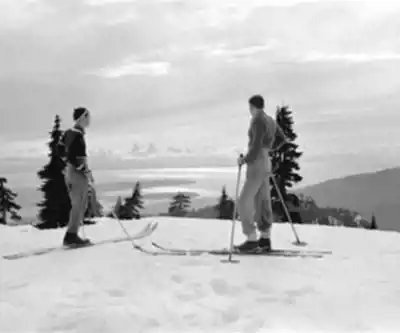
The peak sits within Mount Seymour Provincial Park and carries a dual identity: it's both a working ski area in winter and a premier hiking destination the rest of the year. Named after Frederick Seymour, the second governor of the Colony of British Columbia, the summit is technically referred to as Third Pump Peak — though virtually everyone just calls it Mount Seymour. The name covers the entire ridge system, which includes several distinct summits and a trail network that can keep you busy across multiple visits.
The Trail
The main route to the summit covers 7 kilometers and gains 1,265 meters of elevation, with an estimated hiking time of around 3 hours and 30 minutes. Despite that significant elevation gain, the trail is rated easy — a reflection of how well the route is established and how gradually it builds in difficulty rather than throwing you into steep technical terrain right away.
The trail starts at the ski area's base facilities and immediately puts you into dense coastal forest. Douglas fir, western hemlock, and western red cedar dominate the lower section, their canopy thick enough to feel like a different world from the parking lot you just left. The understory here is lush — ferns, salmonberry, and the kind of deep green that defines the Pacific Northwest coast.
As you gain elevation, the forest character shifts noticeably. Mountain hemlock and alpine fir take over from the coastal giants, and the understory becomes sparser and more rugged. The transition happens gradually, but by the time you're in the upper reaches of the trail, you're clearly in subalpine terrain. During summer, the upper meadows put on a solid wildflower show — Indian paintbrush, lupine, and mountain aster are regulars.
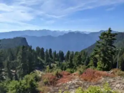
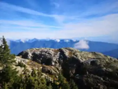
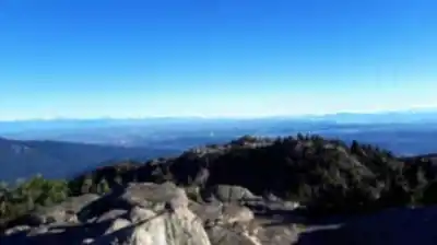
The final push to the summit involves rockier ground and some light scrambling depending on the exact line you take. The payoff is a panoramic view that earns its reputation: Vancouver's skyline across Burrard Inlet to the south, the peaks of Garibaldi Provincial Park to the north, the Fraser Valley stretching east, and the Strait of Georgia and Vancouver Island to the west on a clear day.
Seasons and Conditions
Summer and early fall are the sweet spot for summit hiking. Trails are generally snow-free, weather is more stable, and the views are at their best. That said, the mountain's proximity to the ocean means conditions can shift fast — fog rolls in without much warning, and temperatures at the summit run noticeably cooler than at sea level even in July and August. Layers and a rain shell are worth carrying regardless of the forecast.
Fall brings some of the most visually striking conditions on the mountain. Deciduous trees and shrubs light up against the evergreen backdrop, and the crowds thin out compared to peak summer weekends. The tradeoff is more rain and the real possibility of early snowfall at higher elevations as the season progresses.
Winter hiking on Mount Seymour is a different undertaking entirely. The ski area is running, the trail is buried under snow, and reaching the summit requires proper winter gear, avalanche awareness, and solid backcountry experience. This isn't a casual winter outing. Spring conditions carry their own complications — unstable snowpack, creek crossings running high with snowmelt, and weather that can swing hard in either direction.
Beyond the Summit
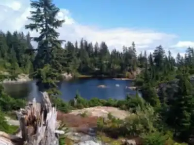
Mount Seymour Provincial Park has a lot more going on than the main summit trail. The trail network spans a wide range of difficulty levels, from easy family-friendly walks to backcountry routes that connect with other peaks along the North Shore. Several alpine lakes are scattered through the park, offering fishing and, for those willing to brave the water temperature, swimming in summer.
Mountain bikers have a strong presence in the park as well, with options ranging from mellow cross-country terrain to technical descents. The trail system connects into the broader North Shore network, which opens up the possibility of multi-day adventures linking several peaks and park areas.
In winter, the park becomes a hub for snow sports beyond just the downhill ski area. Snowshoeing and cross-country skiing are popular throughout the park's terrain. Mount Seymour's relatively lower elevation compared to other North Shore ski areas — Cypress and Grouse Mountain being the main comparisons — means it can be accessible even when snow conditions are marginal elsewhere.
Getting There and Practical Notes
The park sits in the District of North Vancouver, which puts it roughly 45 minutes to an hour from downtown Vancouver depending on traffic. The access road climbs through residential neighborhoods before entering the park and continuing up to the ski area base, where the main trailhead and facilities are located.
Parking fills up fast on summer weekends and holidays, especially when the weather cooperates. Arriving early is the most reliable strategy. Winter parking adds another layer of complexity, with snow removal operations and ski area traffic competing for the same lots.
Basic facilities at the ski area base include washrooms and picnic areas. Once you're past the base and heading into the backcountry, you're on your own — bring everything you need, including navigation tools and emergency supplies. Cell coverage is unreliable through much of the park, so don't count on it for navigation or communication in a pinch.
Recommended gear for this trail


Ready to go?
Everything you need to know before you goStarting Point
The mount seymour trails start at the mount seymour Ski Resort. To get there, take Highway 1 to the mount seymour Parkway exit. Follow the signs to the ski resort.
When?
How much?
- Hiking shoes Essential
- → Salomon Elixir Tour Mid WP · 203.38 $
- Layered clothing Essential
- Rain jacket Essential
- Trekking poles
- → Black Diamond Trail Ergo Cork · 69.99 $
- Headlamp
- → Petzl Actik Core 625 · 103.95 $
FAQ - Frequently asked questions
Everything you need to knowThe Essential Hiking Checklist
Everything you need for your next hike. Bilingual, printable, 1 page.
Download the free checklistSimilar hikes nearby
Discover other trails you might enjoy

Bridle Path
Vancouver Coast Mountains
Flora Lake
Vancouver Coast Mountains

Alouette Mountain
Vancouver Coast Mountains

Williamson Lake
Vancouver Coast Mountains
Brandywine Mountain
Vancouver Coast Mountains

Coliseum Mountain
Vancouver Coast Mountains
Hiking near Vancouver
235 trails to explore ~18 km away
We work hard to provide the most up-to-date and error-free data possible. If something seems incorrect, let us know! Your contribution helps the whole community.
Hikers' opinions