

Ready to explore Panorama Ridge? Here's everything you need to know before you go!
Discover the trail

Trail description
Description
Panorama Ridge is one of British Columbia's most celebrated day hikes, and it earns that reputation every step of the way. Located in Garibaldi Provincial Park within the Vancouver Coast Mountains, this trail delivers a full alpine experience — dense forest, open meadows, volcanic rock, and a summit view that stops you in your tracks. The name isn't an exaggeration: standing on the ridge above Garibaldi Lake is genuinely one of the finest vantage points in the province.
The Route
The trail starts at the Rubble Creek trailhead and covers 15 kilometers one-way, gaining 1,520 meters of elevation along the way. Plan for around 8.5 hours on the trail — this is a full day out, not a quick morning jaunt. The distance and elevation gain put it firmly in the hard category, and that rating is honest. You'll want to be in solid hiking shape before committing to this one.
The first section climbs steadily through old-growth coastal forest. Towering cedars and Douglas firs keep things cool and shaded as you work your way up, and the forest floor has that quiet, mossy feel that's characteristic of the Coast Mountains. It's a good warm-up stretch — the trail is well-defined and the grade is manageable before things get more serious higher up.
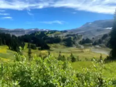
Taylor Meadows marks a significant transition point. The trees open up, the sky gets bigger, and during July and early August the meadows are covered in wildflowers — lupine, paintbrush, mountain asters. It's a natural rest stop and a good place to take stock of how you're feeling before the harder terrain ahead.
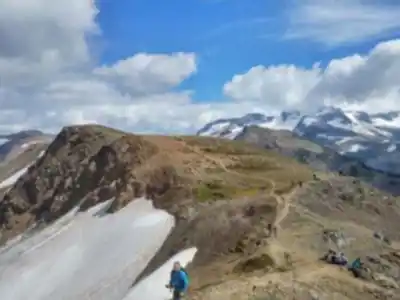
Past the meadows, the trail gets rougher. You're moving through rockier ground with steeper pitches, and the Black Tusk — that unmistakable volcanic spire — comes into full view. It's a useful landmark that tells you you're getting close to the upper mountain. The final push to the ridge involves some scrambling over loose rock and a few exposed sections where you'll want to pay attention to your footing. Nothing technical, but it demands focus.
The View from the Top
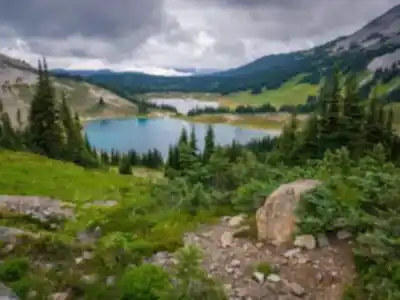
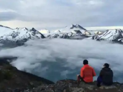
The payoff at Panorama Ridge is the kind of view that makes you forget how tired your legs are. Garibaldi Lake sits directly below, its water an almost surreal shade of turquoise — the result of glacial flour suspended in the water. The contrast between that vivid blue-green and the dark volcanic rock surrounding it is striking in a way that photos don't fully capture. From the ridge, the panorama extends across multiple mountain ranges, with peaks layered to the horizon in every direction. On a clear day, the scale of the Coast Mountains becomes genuinely humbling.
When to Go
The trail is typically accessible from July through October, once the snowpack has cleared at higher elevations. July and August offer the most reliable conditions and the peak wildflower display in the meadows. September is worth considering — the crowds thin out, fall colors start appearing in the alpine zones, and the light has a different quality that makes for excellent photography. By late October, early season snow at elevation becomes a real possibility, and conditions can deteriorate quickly.
This is a popular trail, especially on summer weekends. Starting before 7 AM is strongly recommended — it gives you a buffer for the return trip, helps you avoid the worst of the midday crowds, and means you're on the exposed upper sections before afternoon weather has a chance to build.
What to Bring
Given the distance and elevation, gear choices matter here. A few things worth emphasizing:
- Footwear: Sturdy, broken-in hiking boots. The loose rock on the upper trail is unforgiving on trail runners or worn-out soles.
- Water: Carry at least 3 liters per person. A water filter gives you flexibility if you want to top up from streams along the route.
- Layers: Mountain weather in the Coast Mountains can shift fast. A warm mid-layer and a waterproof shell are worth the weight even on a sunny start.
- Navigation: The main trail is well-traveled, but the final approach to the ridge can be less obvious. A downloaded map or GPS device is good backup.
- Headlamp: If your group moves at a moderate pace or starts later than planned, you'll want one for the return.
On the Ground in Garibaldi Provincial Park
Cell coverage is unreliable for most of the route — don't count on it for navigation or emergency communication. Let someone know your plans and expected return time before you head out. A satellite communicator is worth considering for a hike of this length and remoteness.
Garibaldi Provincial Park sees heavy use, and the alpine terrain is fragile. Stay on the marked trail, pack out everything you bring in, and give wildlife plenty of space if you encounter it. The meadows and ridge areas recover slowly from off-trail traffic — the difference between a well-maintained trail and a degraded one comes down to how each visitor behaves.
Panorama Ridge is a demanding hike that asks a lot from you physically, but it's the kind of trail that reminds you exactly why you got into hiking in the first place.
Recommended gear for this trail


Ready to go?
Everything you need to know before you goStarting Point
The start of the trails at the panorama ridge in British Columbia can be accessed from the parking lot located off of Highway 99.
When?
How much?
- Hiking shoes Essential
- → Salomon Elixir Tour Mid WP · 203.38 $
- Layered clothing Essential
- Rain jacket Essential
- Trekking poles
- → Black Diamond Trail Ergo Cork · 69.99 $
- Headlamp
- → Petzl Actik Core 625 · 103.95 $
FAQ - Frequently asked questions
Everything you need to knowThe Essential Hiking Checklist
Everything you need for your next hike. Bilingual, printable, 1 page.
Download the free checklistSimilar hikes nearby
Discover other trails you might enjoy

Bridle Path
Vancouver Coast Mountains
Flora Lake
Vancouver Coast Mountains

Alouette Mountain
Vancouver Coast Mountains

Williamson Lake
Vancouver Coast Mountains
Brandywine Mountain
Vancouver Coast Mountains

Coliseum Mountain
Vancouver Coast Mountains
Hiking near Whistler
160 trails to explore ~19 km away
We work hard to provide the most up-to-date and error-free data possible. If something seems incorrect, let us know! Your contribution helps the whole community.
Hikers' opinions