

Ready to explore Falls Reserve Conservation Area? Here's everything you need to know before you go!
Discover the trail
Oh no! We don't have any photos 😢
This trail hasn't been captured yet. Be the first to share your adventure!Trail description
Description
Falls Reserve Conservation Area is a quiet gem tucked into Huron County, offering an easy escape into natural landscapes shaped by the Maitland River. The park takes its name from the limestone ledges where the river drops and tumbles, creating natural waterfalls that serve as the centerpiece of any visit. With a mix of river valley, mature hardwood forest, and open meadow, this conservation area packs a lot of variety into a manageable, accessible package.
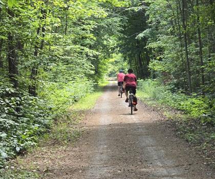
The estimated 45-minute trail experience and gentle 40-metre elevation change make Falls Reserve a solid choice for families, casual walkers, or anyone looking for a low-key outing without sacrificing scenery. The terrain is approachable without being boring — you'll notice the land shifting as trails dip toward the river or rise to overlook points above the falls.
Trail Experience and Terrain
The trails at Falls Reserve follow the natural shape of the Maitland River valley, moving through stands of maple, oak, and beech before opening onto riverside viewpoints. The paths are well-maintained and clearly marked, so navigation is straightforward even for first-time visitors. Elevation changes are gradual — the 40-metre relief is enough to give the hike some character without making it a workout.
The main draw is reaching the viewpoints where the Maitland River flows over the limestone formations. The sound of moving water follows you through much of the hike, and when you arrive at the falls themselves, the limestone ledges double as natural seating — a good spot to slow down, take photos, or just listen. The rock formations are visually striking, and the interplay of water, stone, and surrounding forest gives the area a distinct character that sets it apart from flatter conservation areas in the region.
River access points along the route let you get close to the water. Shallow sections reveal a clear stream running over smooth rock, and the footing is generally stable. That said, wet limestone can be deceptively slippery — footwear with solid grip is worth prioritizing before you head out.
Wildlife and Natural Features
The mix of habitats within Falls Reserve — river corridor, deciduous forest, and open meadow — supports a solid range of wildlife. White-tailed deer are a regular sight, especially in the meadow areas during early morning or late afternoon. They tend to be relaxed around quiet visitors, which makes for unhurried observation.
The river draws kingfishers and great blue herons, both of which are reliably present through the warmer months. Herons in particular are easy to spot standing motionless in the shallows, waiting out fish with impressive patience. The forested sections host woodpeckers, nuthatches, and a rotating cast of seasonal songbirds — worth bringing binoculars if birds are on your radar.
Along the sunny stretches of riverbank, painted turtles bask on exposed rocks. They'll tolerate a slow approach but will slide into the water if you push it. The limestone environment also supports amphibians that tend to be more active in the evening hours.
Family-Friendly Features
Falls Reserve works well as a family destination. The trail distances and easy difficulty rating mean that younger or less experienced hikers can reach the waterfall viewpoints without issue. The shallow river sections are a natural draw for kids — wading, rock-flipping, and spotting crayfish or small fish in the clear water can easily extend a visit well beyond the trail itself. Supervision near the water is important, and water shoes or sturdy sandals are a good call for anyone planning to wade.
Picnic tables and grills are available in designated areas, positioned close enough to parking and restrooms to be convenient while still feeling embedded in the natural setting. It's a setup that works well for a full-day outing rather than just a quick walk.
Camping Options
For those who want to stretch the visit into an overnight stay, Falls Reserve offers both unserviced and serviced camping sites. Unserviced sites suit campers who prefer a more self-sufficient, rustic experience — falling asleep to river sounds rather than road noise is a genuine selling point here. Serviced sites with electrical hookups accommodate RVs and those who want a few more conveniences without giving up the outdoor setting.
Both site types connect to the trail system, which opens up the possibility of early morning or evening hikes when wildlife is most active and day-use crowds are minimal. Spring conditions can affect site availability due to snowmelt and potential flooding, so checking with the conservation area before arrival is a good habit.
Planning Your Visit
Reaching out to Falls Reserve staff before your visit is worthwhile, particularly in spring when snowmelt can temporarily close riverside sections, or in fall when heavy leaf cover can obscure trail markers in the forested areas. Staff can also flag any guided walks or programming that might be running during your visit.
The river valley tends to run cooler than the surrounding landscape, especially in spring and fall, so layering is a smart move regardless of what the forecast says. Good hiking footwear is non-negotiable if you plan to explore the riverside areas — the combination of wet rock and limestone makes grip a priority rather than an afterthought.
Recommended gear for this trail


Ready to go?
Everything you need to know before you goStarting Point
The falls reserve conservation area is located in Ontario, Canada. To get to the start of the trails, take Highway 401 to exit 496 and go north on County Road 2. The conservation area will be on the right.
When?
How much?
- Hiking shoes Essential
- → Salomon Elixir Tour Mid WP · 203.38 $
- Layered clothing Essential
- Rain jacket Essential
- Trekking poles
- → Black Diamond Trail Ergo Cork · 69.99 $
- Headlamp
- → Petzl Actik Core 625 · 103.95 $
FAQ - Frequently asked questions
Everything you need to knowThe Essential Hiking Checklist
Everything you need for your next hike. Bilingual, printable, 1 page.
Download the free checklistSimilar hikes nearby
Discover other trails you might enjoy
Perth Harvest Pathway Milverton- G2G Rail Trail
Huron, Perth, Waterloo and Wellington

Health Valley Trail
Huron, Perth, Waterloo and Wellington
Mill Run Trail
Huron, Perth, Waterloo and Wellington
Waterloo Park
Huron, Perth, Waterloo and Wellington
Point Farms Provincial Park
Huron, Perth, Waterloo and Wellington
Breithaupt Park
Huron, Perth, Waterloo and Wellington
Hiking near Kitchener
142 trails to explore ~97 km away
We work hard to provide the most up-to-date and error-free data possible. If something seems incorrect, let us know! Your contribution helps the whole community.
Hikers' opinions