

Ready to explore Meadowlily Trail? Here's everything you need to know before you go!
Discover the trail
Oh no! We don't have any photos 😢
This trail hasn't been captured yet. Be the first to share your adventure!Trail description
Description
Meadowlily Trail winds through some of Southwest Ontario's most diverse natural landscapes, offering hikers a genuine escape into the region's ecological richness. The trail cuts through Meadowlily Woods, creating a natural corridor that connects wetlands, mature forests, and open meadows in a seamless hiking experience that feels much longer than its actual distance.
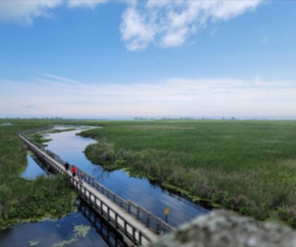
The trail's greatest strength lies in its variety. You'll start in dense woodland where towering maples and oaks create a natural canopy overhead, their branches filtering sunlight into dappled patterns on the forest floor. The well-maintained path here is soft underfoot, cushioned by years of fallen leaves that crunch satisfyingly with each step. As you progress, the forest opens into wetland areas where the ecosystem shifts dramatically — cattails and sedges replace the hardwoods, and the air carries the earthy scent of marsh water.
The transition from forest to meadow happens gradually, then all at once. You'll emerge from tree cover into expansive open spaces where wildflowers create seasonal displays that change throughout the year. These meadows serve as the trail's centerpiece, offering unobstructed views and a sense of space that makes this hike feel larger than its modest length suggests.
Thames River Connection
One of Meadowlily Trail's most compelling features is its relationship with the Thames River. The path runs parallel to the riverbank for a significant portion, close enough that you can hear the water's gentle movement even when it's not visible through the trees. When the trail does open up to river views, you'll find yourself walking along a natural corridor where the water moves slowly and deliberately through the landscape.
The riverbank sections provide the best wildlife viewing opportunities on the trail. Turtles regularly bask on fallen logs and sun-warmed rocks, often remaining still enough for close observation if you approach quietly. The slower sections of the river support fish populations that attract both wading birds and the occasional angler, though fishing access varies along the route.
These riverside stretches also offer natural rest stops where you can sit on rocks or fallen logs and simply watch the water flow. The sound of the Thames here is subtle but constant — not the rushing of a mountain stream, but the steady, peaceful movement of a mature river working its way through southwestern Ontario's gentle topography.
Wildlife and Ecosystems
The trail's diverse habitats support an impressive variety of wildlife for such a compact area. The wetland sections attract waterfowl, particularly during spring and fall migrations, while the forest areas provide habitat for woodland birds year-round. Interpretive signs placed along the route help identify both the ecosystems you're walking through and the species you're likely to encounter.
Birdwatching opportunities shift with the habitats you're moving through. The wetlands attract red-winged blackbirds, various waterfowl, and the occasional great blue heron, while the forest sections host woodpeckers, nuthatches, and seasonal warblers. The open meadows provide hunting grounds for hawks and open territory for grassland species.
Photography opportunities abound throughout the trail, from macro shots of wildflowers in the meadows to landscape compositions where the Thames River creates natural leading lines through the frame. The variety of ecosystems means you can capture completely different types of images within a single outing, making this trail particularly rewarding for photographers looking to document Ontario's natural diversity.
Trail Conditions and Navigation
The path is well-maintained and clearly marked throughout, making navigation straightforward for hikers of any experience level. The trail surface varies with the terrain — soft forest floor in the wooded sections, occasionally muddy areas near the wetlands, and firmer ground through the meadows. The elevation change is gentle at around 30 metres, so you'll notice the slight undulation without it ever feeling like a workout.
The interpretive signs serve a dual purpose: they provide educational content about the area's natural history while also acting as reliable waypoints for navigation. These signs are positioned at key transition points between ecosystems, helping you understand what you're seeing while confirming you're on the right path.
While the trail is rated easy and accessible for beginners, the variety of terrain means you'll experience more than just a simple walk in the woods. The different surfaces — from forest loam to meadow grass to occasional rocky sections near the river — provide enough variation to keep the hike interesting throughout.
Seasonal Considerations
Meadowlily Trail offers distinct experiences throughout the year, with spring and fall providing particularly spectacular displays. Spring brings wildflower blooms in the meadows and fresh green growth throughout the forest, while fall transforms the hardwood sections into a showcase of changing colour. The wetland areas remain interesting year-round, though they're most active during migration periods.
The trail stays open throughout the year, but conditions vary significantly with the seasons. Spring can bring muddy conditions, particularly in the wetland transitions. Summer provides the fullest forest canopy and the most active wildlife, though it can also mean more insects in the wetland areas. Winter offers a completely different perspective on the same landscapes — quieter, starker, and worth the visit if you're dressed for it.
What to Bring
- Footwear: Comfortable hiking shoes that can handle varied terrain and occasional mud — trail runners or light hikers work well here.
- Water: Essential even on this relatively short trail, particularly during warmer months when the open meadow sections offer little shade.
- Binoculars: Highly recommended given the strong birdwatching opportunities, especially in the wetland and meadow sections.
- Camera: The ecosystem variety makes this one of the more photogenic trails in the area, regardless of the season.
- Bug repellent: Worth packing during summer months, particularly if you plan to linger near the wetlands.
The combination of easy access, gentle elevation, and genuinely diverse ecosystems makes Meadowlily Trail an excellent choice for both solo exploration and group outings — rewarding enough for experienced hikers while remaining approachable for anyone new to trail hiking in southwestern Ontario.
Recommended gear for this trail


Ready to go?
Everything you need to know before you goStarting Point
The meadowlily trail is located in the town of Ontario in Wayne County, New York. To get to the start of the trails, take exit 42 off of Interstate 90 and head north on Route 104. The trailhead will be on your right after about 1.5 miles.
When?
How much?
- Hiking shoes Essential
- → Salomon Elixir Tour Mid WP · 203.38 $
- Layered clothing Essential
- Rain jacket Essential
- Trekking poles
- → Black Diamond Trail Ergo Cork · 69.99 $
- Headlamp
- → Petzl Actik Core 625 · 103.95 $
FAQ - Frequently asked questions
Everything you need to knowThe Essential Hiking Checklist
Everything you need for your next hike. Bilingual, printable, 1 page.
Download the free checklistSimilar hikes nearby
Discover other trails you might enjoy

Lynn Valley Trails
Southwest Ontario
Point Pelee National Park High Point, Ontario
Southwest Ontario
Oxford Thames River Trail
Southwest Ontario
Pinery Provincial Park
Southwest Ontario
Ojibway Prairie Provincial Nature Reserve
Southwest Ontario
Springbank Park
Southwest Ontario
Hiking near Kitchener
142 trails to explore ~77 km away
We work hard to provide the most up-to-date and error-free data possible. If something seems incorrect, let us know! Your contribution helps the whole community.
Hikers' opinions
Be the first to review!
No hiker has shared their experience yet. Share your impressions and help other hikers!