

Ready to explore Oxford Thames River Trail? Here's everything you need to know before you go!
Discover the trail
Oh no! We don't have any photos 😢
This trail hasn't been captured yet. Be the first to share your adventure!Trail description
Description
The Oxford Thames River Trail follows the Thames River through some of Southwest Ontario's quieter countryside, offering a relaxed day hike that balances natural variety with easy accessibility. This is the kind of trail that rewards hikers who aren't chasing elevation or technical challenge — instead, you get a genuine connection to the river landscape, a mix of forest and open terrain, and enough solitude to actually hear the water moving beside you.
Trail Character and Terrain
The trail moves through several distinct environments as it follows the Thames, and that variety is what keeps the walk interesting from start to finish. Dense hardwood forest dominates portions of the route, with mature oak, maple, and hickory forming a canopy that stays cool and shaded even during the warmest summer days. The forest floor here is soft underfoot — packed earth with occasional root crossings that ask for a bit of attention but nothing that requires technical footwear or experience.
As the path opens up, you transition into meadow sections where the views stretch across the Thames valley. These open stretches are where you'll feel the most exposed to weather, but they also offer the longest sightlines and the best light for photography. Wildflowers push through in late spring and early summer, and the contrast between these bright open areas and the shaded forest corridors gives the hike a natural rhythm.
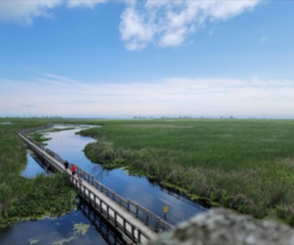
Boardwalk sections appear where the trail crosses wetland areas, keeping your feet dry and giving you a slightly elevated perspective over the cattails and sedges below. The overall elevation change is minimal at 50 metres — this trail follows the river's natural contours rather than climbing away from the water, so the gentle ups and downs feel organic rather than demanding.
River access points appear at regular intervals, and it's worth stopping at a few of them. The Thames runs relatively shallow through this section, with small pools, rocky stretches, and sandy shoreline areas that invite a rest. The sound of moving water stays with you for most of the hike, which adds a lot to the overall experience.
Wildlife and Natural Features
The mix of forest, meadow, wetland, and river corridor creates conditions that support a wide range of wildlife. White-tailed deer are a common sight, particularly in the meadow sections during early morning and evening hours — they tend to graze calmly and don't spook easily if you move quietly. The wetland areas attract red-winged blackbirds and various waterfowl, while the river itself brings great blue herons and kingfishers into regular view.
The forested sections support woodpeckers, nuthatches, and during spring migration, warblers moving through the Carolinian forest. The meadows draw hawks and butterflies in summer, and groundhogs and rabbits are frequently spotted in the drier open areas. The Carolinian forest ecosystem here — characterized by those oak, maple, and hickory stands — is ecologically significant for this part of Ontario, supporting species that reach the northern edge of their range in Southwest Ontario.
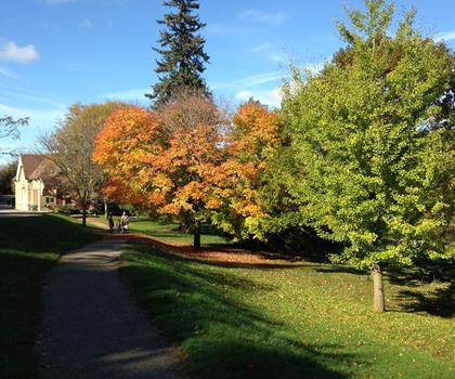
Fall is a particularly strong season on this trail. The hardwood canopy turns brilliant oranges and reds, and the lower visitor numbers compared to summer mean you're likely to have long stretches of the path entirely to yourself.
Points of Interest
Pittock Conservation Area connects to the trail and functions as both an access point and an extension of your hiking day. The conservation area includes additional paths with more elevation change and denser forest cover — a useful contrast to the gentler river walk if you want to add distance or variety. Picnic areas overlook Pittock Reservoir, with views across the water to the rolling farmland beyond, making it a natural lunch stop.
For anyone interested in the cultural context of the landscape, the Ingersoll Cheese & Agricultural Museum nearby offers a look at how farming has shaped the Thames River valley over the past two centuries. The agricultural land visible from the trail's open sections makes more sense with that history in mind.
Practical Information
The estimated hiking time is around 1.5 hours at a comfortable pace. Trail shoes or sturdy hiking boots with decent traction handle the varied surfaces well — the forested sections can get muddy after rain, and the root crossings are easier with footwear that grips. Waterproof boots are worth considering in spring when snowmelt and rain can leave sections soft.
There are no facilities along the trail itself, so bring water and snacks from the start. The open meadow sections offer no shelter during storms, so check the forecast before heading out and dress in layers that can handle changing conditions. The trail is generally well-marked, and the river itself provides reliable orientation throughout.
Multiple access points along the trail allow you to adjust the length of your hike depending on available time and energy. The main access connects easily from the Woodstock and London area, making this a practical option for both local hikers and visitors passing through Southwest Ontario.
Access and Parking
Parking is available at several access points along the trail's length. The proximity to major highways between London and Woodstock keeps the drive straightforward from either direction. The multiple entry points also mean you can plan a point-to-point hike with a vehicle shuttle, or simply choose a section that fits your schedule without committing to the full route.
Practice Leave No Trace throughout — pack out everything you bring in, and keep noise down in the wildlife-rich meadow and wetland sections to give yourself the best chance of seeing what lives here.
Recommended gear for this trail


Ready to go?
Everything you need to know before you goStarting Point
The oxford thames river trail is located in the town of Ingersoll, Ontario. To get to the start of the trails, take Highway 401 to exit 218 and head north on County Road 2. The trailhead will be on your right.
When?
How much?
- Hiking shoes Essential
- → Salomon Elixir Tour Mid WP · 203.38 $
- Layered clothing Essential
- Rain jacket Essential
- Trekking poles
- → Black Diamond Trail Ergo Cork · 69.99 $
- Headlamp
- → Petzl Actik Core 625 · 103.95 $
FAQ - Frequently asked questions
Everything you need to knowThe Essential Hiking Checklist
Everything you need for your next hike. Bilingual, printable, 1 page.
Download the free checklistSimilar hikes nearby
Discover other trails you might enjoy

Lynn Valley Trails
Southwest Ontario
Point Pelee National Park High Point, Ontario
Southwest Ontario
Ojibway Prairie Provincial Nature Reserve
Southwest Ontario
Pinery Provincial Park
Southwest Ontario
Springbank Park
Southwest Ontario
Fingal Wildlife Management Area
Southwest Ontario
Hiking near Kitchener
142 trails to explore ~48 km away
We work hard to provide the most up-to-date and error-free data possible. If something seems incorrect, let us know! Your contribution helps the whole community.
Hikers' opinions