


Ready to explore Cascades du Hérisson? Here's everything you need to know before you go!
Discover the trail
Trail description
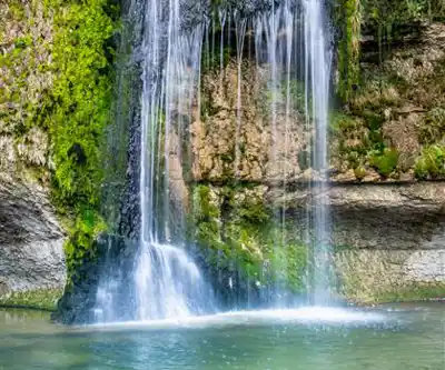
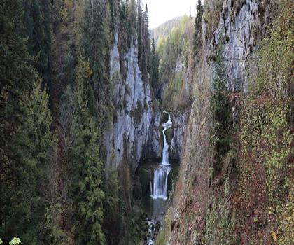
The Cascades du Hérisson trail winds through one of the Jura's most spectacular waterfall valleys, where the Hérisson River tumbles down a series of dramatic limestone steps through dense forest. This popular 7.2-kilometer hiking route showcases seven major waterfalls over its course, each with distinct character and viewing opportunities that make it a standout destination in the Franche-Comté region. With 255 meters of elevation gain spread across approximately 2.5 hours of hiking, the trail offers a moderate challenge that rewards hikers with some of the most impressive cascade formations in eastern France.
The trail follows the Hérisson River as it carves through ancient limestone formations, creating a natural staircase of cascades that range from gentle curtains of water to thundering plunges. The forest canopy overhead consists primarily of beech, fir, and spruce, creating a cool, humid microclimate that supports lush moss growth on the rock faces and fallen logs. During spring snowmelt and after heavy rains, the waterfalls reach their most impressive volumes, while late summer reveals more of the underlying rock structure and creates quieter pools perfect for observing the interplay of light and water.
The Seven Waterfall Sequence
Starting from the lower access point, hikers encounter the waterfalls in ascending order of drama. The first cascade, Cascade de l'Éventail, spreads across a wide rock face like an opened fan, giving it its name. The trail here runs close to the water level, allowing you to feel the mist and hear the constant murmur of flowing water that will accompany much of your hike. This gentle introduction sets the tone for the increasingly dramatic displays ahead.
The Cascade du Grand Saut commands attention as the tallest waterfall in the sequence, plunging 60 meters in a single dramatic drop. The viewing platform here provides an excellent vantage point for photography, though the best light typically occurs in late morning when sunbeams penetrate the forest canopy. The sound is overwhelming when you're standing directly below, and the spray creates a refreshing mist that's particularly welcome during summer hikes.
Further upstream, the Cascade de la Forge and Cascade du Château du Hérisson each offer their own character. The Forge waterfall tumbles over a series of rocky ledges, creating multiple tiers that photograph beautifully, while the Château cascade marks the upper portion of the trail where the valley opens slightly and the forest composition shifts toward more mixed deciduous trees. The final waterfalls, including the Cascade du Saut Girard, often catch visitors by surprise with their volume and the way they seem to emerge from the forest itself.
Trail Conditions and Navigation
The path varies significantly in character along its 7.2-kilometer length. Lower sections follow well-maintained gravel paths suitable for most fitness levels, while the middle portions involve stone steps, some steep sections, and occasional scrambling over roots and rocks. The trail surface can be slippery when wet, particularly on the limestone sections near the waterfalls where spray creates consistently damp conditions.
The 255 meters of elevation gain is distributed unevenly throughout the hike. You'll encounter some flat stretches along the river followed by steeper climbs to reach upper viewing points. The most challenging section occurs between the middle waterfalls, where the trail climbs directly alongside the gorge. Here, wooden railings and strategically placed stone steps help navigate the terrain, but the footing requires attention.
Wooden bridges cross the river at several points, and while these are generally sturdy, they can be slick during wet weather. Trail markers are frequent and clear, featuring the distinctive yellow and red blazes common to French hiking trails. The sound of rushing water can sometimes mask the noise of other hikers, so maintaining awareness of your surroundings is important, especially during busy periods when the narrow trail sections can become congested.
Seasonal Waterfall Experiences
Spring brings the highest water levels and most dramatic waterfall displays, typically from March through May. Snowmelt from the Jura highlands feeds the Hérisson River, creating thunderous cascades that can be heard from considerable distances. The forest floor during this period showcases wildflowers including wood anemones and wild garlic, while the canopy remains relatively open before full leaf-out. However, spring also means muddier trail conditions and potentially icy patches in shaded areas.
Summer offers the most comfortable hiking conditions with dry trails and full forest canopy, though waterfall volumes decrease significantly during dry periods. The cool microclimate of the gorge provides welcome relief during hot weather, with temperatures often 5-10 degrees cooler than the surrounding plateau. This makes the Cascades du Hérisson a popular escape for regional residents during heat waves.
Autumn transforms the deciduous portions of the forest into brilliant displays of yellow and orange, while the waterfalls regain some volume from fall rains. This season often provides the best combination of good trail conditions and scenic beauty, with the added bonus of fewer crowds than peak summer months.
Winter hiking reveals a completely different character as ice forms around the waterfalls, creating spectacular frozen formations. However, this beauty comes with significant challenges, as the trail becomes treacherous. Microspikes or light crampons become essential, and some upper sections may be impassable depending on conditions.
Access Points and Parking Strategy
Multiple access points serve the trail, with the most popular parking areas located at both the upper and lower ends of the waterfall sequence. The lower parking area near Doucier fills quickly during peak season and summer weekends, so early morning starts are recommended. This lot provides direct access to the trail's beginning and allows you to experience the waterfalls in their intended sequence.
Additional parking exists at the upper access near the village of Ilay, though this involves hiking the trail in reverse order. Some hikers prefer this approach as it means encountering the Grand Saut early in the hike when energy levels are highest. A third option involves parking at intermediate points and hiking shorter sections, though this requires more complex logistics.
Public transportation options are limited in this rural area of the Jura, making personal vehicles the most practical access method for most visitors. The nearest major town with full services is Lons-le-Saunier, approximately 30 minutes by car from the trailhead.
Wildlife and Geological Features
The Hérisson valley supports diverse wildlife adapted to the moist forest environment. Red squirrels are commonly spotted, particularly in the coniferous sections, while the river itself supports populations of brown trout that can sometimes be observed in the calmer pools between cascades. Bird life includes various woodpecker species, whose drumming often echoes through the gorge, and dippers that nest near the waterfalls and can be observed diving for insects in the rushing water.
The limestone geology creates interesting formations beyond just the waterfalls, including small caves and overhangs that provide shelter during sudden weather changes. The rock faces display clear stratification from ancient marine deposits, and the constant water flow has carved intricate patterns and potholes that demonstrate the power of erosion over geological time. Moss and lichen growth on the rock faces creates intricate patterns that change with the seasons and moisture levels.
Practical Hiking Considerations
Sturdy hiking boots with good traction are essential due to the frequently wet and slippery conditions, particularly on the limestone sections. Trekking poles can be helpful for the steeper sections and when crossing wet rocks, though they're not absolutely necessary for most hikers. A lightweight rain jacket is advisable regardless of the forecast, as the microclimate in the gorge can produce sudden showers even on otherwise clear days.
The trail is generally suitable for older children and teenagers with reasonable hiking experience, though parents should maintain close supervision near the water and on steep sections. The combination of water features and varied terrain typically holds children's interest well, making this a good family destination for those comfortable with moderate hiking challenges. The 2.5-hour duration allows for a substantial outdoor experience without being overwhelming for younger hikers.
The Essential Hiking Checklist
Everything you need for your next hike. Bilingual, printable, 1 page.
Get your free hiking checklistRecommended gear for this trail
As an Amazon Associate I earn from qualifying purchases.


Ready to go?
Everything you need to know before you goWhen?
How much?
As an Amazon Associate I earn from qualifying purchases.
Affiliate links — LGPO may earn a commission at no extra cost to you.
- Hiking shoes Essential
- → Salomon Elixir Tour Mid WP · 203.38 $
- Layered clothing Essential
- Rain jacket Essential
- Trekking poles
- → Black Diamond Trail Ergo Cork · 69.99 $
- Headlamp
- → Petzl Actik Core 625 · 103.95 $
FAQ - Frequently asked questions
Everything you need to knowSimilar hikes nearby
Discover other trails you might enjoy

Hiking near Sydney
22 trails to explore ~4926 km away
We work hard to provide the most up-to-date and error-free data possible. If something seems incorrect, let us know! Your contribution helps the whole community.
Hikers' opinions
Be the first to review!
No hiker has shared their experience yet. Share your impressions and help other hikers!