

Ready to explore Jordan River? Here's everything you need to know before you go!
Discover the trail

Trail description
Description
Jordan River is a small coastal community on the southwest shore of Vancouver Island, sitting right where dense temperate rainforest meets the open Pacific. It's best known as an access point for the Juan de Fuca Marine Trail, but the area offers plenty on its own — dramatic shoreline, old-growth forest, and beaches that reward exploration at any pace. With a total distance of 15 km, 200 m of elevation gain, and an estimated 4 hours 15 minutes to complete, this is rated an easy route that works well for hikers who want a full day out without a grueling climb.
The Landscape
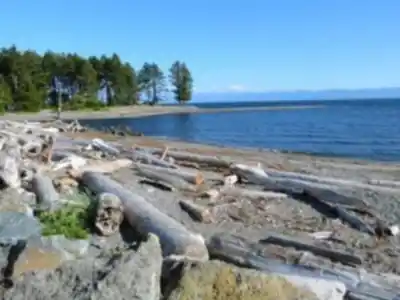
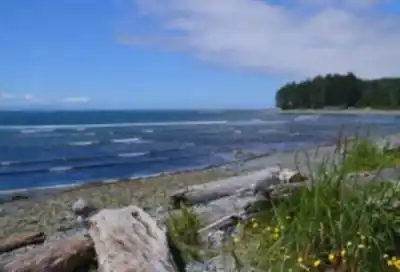
The scenery here is classic West Coast Vancouver Island. Towering Sitka spruce and western red cedar dominate the forest, their canopies filtering light down onto a floor thick with salal, sword ferns, and moss. Step out of the trees and you're on rocky shoreline or sandy beach, with the Pacific stretching out to the horizon. Sandstone shelves exposed at low tide are riddled with tide pools, and the sound of surf is constant throughout the hike.
The interplay between forest and coast is what makes Jordan River stand out. You're not just walking through one type of terrain — the trail moves back and forth between cathedral-like old-growth sections and open coastal stretches, which keeps the experience varied and visually interesting from start to finish.
The Juan de Fuca Marine Trail
The main hiking draw in the Jordan River area is the Juan de Fuca Marine Trail, a coastal route that follows the shoreline and dips in and out of the rainforest. You don't need to tackle the full trail — multiple trailheads allow you to plan a day hike of whatever length suits you. The Jordan River access point is one of the more popular starting spots, giving you flexibility in how far you go and when you turn around.
The trail surface changes frequently. Some sections run along well-maintained forest paths with wooden boardwalks and bridges over wet areas and creek crossings. Others require more attention underfoot — rocky coastal sections, exposed roots from massive trees, and stretches of loose sand or rounded stones near the water. None of it is technically difficult, but you do need to stay focused, especially when conditions are wet.
Mystic Beach and Coastal Highlights
One of the most rewarding destinations accessible from the Jordan River area is Mystic Beach. The route there involves some steeper terrain and rougher footing compared to the flatter coastal sections, but the payoff is a pristine stretch of sand with waterfalls that drop directly onto the beach. The tide pools here are excellent — sea anemones, hermit crabs, and sea stars are common finds at low tide. Timing your visit around low tide makes a significant difference in what you can access and explore.
Along the broader coastline, driftwood-lined beaches invite slower exploration. The logs, worn smooth by years of tides, double as natural seating for a break with a view. Beachcombing turns up shells, interesting pieces of wood, and occasionally more unusual finds. During winter, storm-watching from the shore is spectacular — Pacific swells build into powerful surf, and the spray and sound are something else entirely.
Wildlife
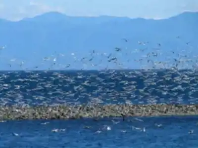
The Jordan River area is genuinely good for wildlife. Bald eagles are a regular sight overhead, and ravens and Steller's jays are common throughout the forest sections. Harbor seals and sea lions show up in the offshore waters, and during migration seasons gray whales are sometimes visible from elevated points along the trail. Black bears do move through the area, particularly when salmon are running, so making noise on the trail is a reasonable habit here. The shorebird activity picks up during migration periods, with sandpipers and plovers using the beaches as stopover habitat.
Trail Conditions
Wet conditions are the norm on this stretch of coast, not the exception. Trails can be muddy year-round, and root systems crossing the path create tripping hazards when slick. Beach sections add their own challenges — loose sand and wet rounded stones are less stable than they look. Fog rolls in quickly and can cut visibility significantly, which is worth keeping in mind if you're relying on sightlines for navigation.
Tides directly affect what's hikeable. Some beach sections become impassable at high tide, so checking a tide table before you head out is genuinely useful, not just a nice-to-have. Low tide opens up the best tide pooling and gives you access to firm sand for easier walking.
What to Bring
A few things make a real difference on this trail:
- Sturdy waterproof hiking boots with good ankle support — the combination of mud, roots, rocks, and wet sand will test footwear quickly.
- Layered clothing — coastal temperatures can be cool even in summer, and conditions shift fast. What starts as a clear morning can turn foggy and damp by afternoon.
- More water than you think you need — natural water sources along the route aren't reliably safe to drink without treatment, and the ocean air and physical effort add up.
- A tide table — free to look up online before you leave, and genuinely useful for planning your route and timing.
Follow Leave No Trace principles throughout — pack out everything you pack in, stay on designated trails, and give wildlife plenty of space. The coastal ecosystem here is sensitive, and keeping it intact is what makes it worth coming back to.
Recommended gear for this trail


Ready to go?
Everything you need to know before you goStarting Point
The start of the trails at the jordan river can be accessed by travelling east on Highway 1 to Exit 123. Turn left onto the Old Hope Princeton Highway and drive for 9 km. Turn right onto the Westside Road and drive for 9 km. Turn left onto the jordan river Forest Service Road and drive for 2 km. The trailhead is located on the right side of the road.
When?
How much?
- Hiking shoes Essential
- → Salomon Elixir Tour Mid WP · 203.38 $
- Layered clothing Essential
- Rain jacket Essential
- Trekking poles
- → Black Diamond Trail Ergo Cork · 69.99 $
- Headlamp
- → Petzl Actik Core 625 · 103.95 $
FAQ - Frequently asked questions
Everything you need to knowThe Essential Hiking Checklist
Everything you need for your next hike. Bilingual, printable, 1 page.
Download the free checklistSimilar hikes nearby
Discover other trails you might enjoy

Sandbar Trail
Vancouver Island

Old Baldy Mountain Trail
Vancouver Island
Wittys Lagoon
Vancouver Island
Mount Cain
Vancouver Island
Kings Peak
Vancouver Island
Buttle Lake
Vancouver Island
Hiking near Victoria
93 trails to explore ~50 km away
We work hard to provide the most up-to-date and error-free data possible. If something seems incorrect, let us know! Your contribution helps the whole community.
Hikers' opinions