

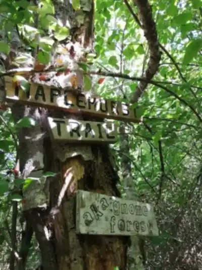
Ready to explore Maplehurst Trails? Here's everything you need to know before you go!
Discover the trail
Trail description
Description
Maplehurst Trails offers a refreshing escape into Vancouver Island's coastal forest ecosystem, where well-maintained pathways wind through some of the island's most accessible old-growth terrain. Located in the island's interior, this trail network provides hikers with an authentic Pacific Northwest forest experience without the crowds that plague more famous destinations.
Trail Network and Terrain
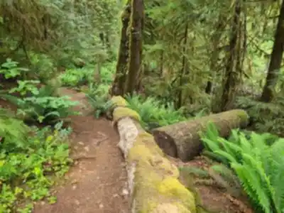
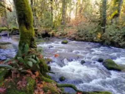
The trail system consists of interconnected loops that traverse two distinct environments. The lower elevation paths meander through dense coastal forest dominated by towering Douglas firs and Western red cedars, some reaching impressive girths that hint at the area's old-growth heritage. The forest floor here remains relatively open beneath the thick canopy, carpeted with sword ferns and salal that create natural corridors between the massive tree trunks.
As you gain elevation through the moderate 150-meter climb, the forest composition shifts subtly. The canopy opens in places, allowing shafts of sunlight to illuminate patches of Oregon grape and huckleberry bushes. These openings provide glimpses of the surrounding landscape and serve as natural rest stops where the forest's layered ecosystem becomes most apparent.
The upper portions of the trail network lead into more open meadow areas where the dense forest gives way to seasonal wildflower displays and broader views. Here, the terrain becomes more varied with gentle rolling hills and small clearings that offer different perspectives on the surrounding mountains and valleys.
Hiking Experience and Route Options
The trail system accommodates a wide range of hiking abilities through its network of interconnected paths. The easier routes follow gentle contours through the lower forest sections, making them ideal for families with young children or anyone seeking a peaceful forest walk without significant physical demands. These paths maintain relatively level grades and feature well-established footing on packed earth and occasional wooden boardwalk sections.
For hikers wanting more challenge, the longer routes incorporate steeper sections and more varied terrain as they climb toward the meadow areas. These paths require more sustained effort but reward hikers with the best viewpoints and the most diverse scenery the area offers. The moderate difficulty rating reflects terrain that most reasonably fit hikers can handle, though the longer routes do demand basic hiking fitness.
The estimated hour and a half duration allows for a comfortable pace with time to appreciate the forest's intricate details. You'll find yourself naturally slowing down to examine the massive nurse logs that support entire communities of smaller plants, or to listen for the subtle sounds that reveal the forest's active wildlife community.
Wildlife and Natural Features
The diverse habitats within Maplehurst Trails support Vancouver Island's characteristic wildlife populations. Black-tailed deer frequently browse along the trail edges, particularly in the early morning and evening hours when they move between forest cover and the more open meadow areas. Their well-worn paths often intersect the main trails, creating opportunities for quiet observation.
The mature forest canopy attracts various bird species throughout the year. Bald eagles nest in the area and can often be spotted soaring above the treeline, while the dense understory provides habitat for smaller forest birds. Great horned owls and barred owls inhabit the deeper forest sections, and their calls often echo through the trees during dawn and dusk hours.
The forest itself showcases the complex ecosystem relationships that define coastal British Columbia. Massive nurse logs support entire communities of smaller plants, while the interplay between the dominant conifers and understory vegetation creates the multilayered habitat structure that supports the area's biodiversity. The moss-covered bark and fallen logs create a living carpet that demonstrates the forest's continuous cycle of growth and renewal.
Seasonal Highlights
Each season transforms the Maplehurst Trails experience in distinct ways. Spring brings the forest floor to life with trilliums, bleeding hearts, and other native wildflowers that emerge before the canopy fully leafs out. The meadow areas burst with color as lupines, paintbrush, and other wildflowers reach peak bloom from late spring into early summer.
Summer provides the most comfortable hiking conditions with warm, dry weather and clear skies that make the mountain and valley views particularly spectacular. The forest offers natural cooling, making even the warmest days pleasant for hiking. This season also offers the longest daylight hours for extended exploration of the trail network's various loops.
Autumn transforms the understory vegetation into brilliant displays of red and gold, while the evergreen canopy provides a dramatic backdrop. The changing light creates exceptional photography opportunities, and the cooler temperatures make for comfortable hiking conditions. The contrast between the colorful deciduous understory and the towering evergreens becomes particularly striking.
Winter hiking remains viable year-round, though conditions become more challenging. The forest takes on a quiet, contemplative character with crisp air and occasional frost highlighting the intricate details of bark, moss, and winter vegetation. The reduced daylight hours require earlier starts, but the peaceful atmosphere rewards those who venture out during the quieter season.
What Makes This Trail Special
Maplehurst Trails stands out among Vancouver Island's hiking destinations for its accessibility combined with genuine old-growth forest character. While many coastal trails require significant travel time or challenging approaches, this network provides immediate immersion in mature forest ecosystems. The variety within the trail system means you can customize your experience based on available time, energy level, and interests.
The interconnected loop design allows for flexible route planning. You can stick to the gentler lower sections for a contemplative forest walk, or combine multiple loops for a more comprehensive exploration that includes the elevated viewpoints and meadow areas. This flexibility makes it an ideal destination for groups with varying fitness levels or for repeat visits that reveal different aspects of the ecosystem.
Preparation and Practical Tips
Sturdy hiking footwear provides essential traction on the varied terrain, particularly during wet conditions when roots and rocks can become slippery. The well-maintained trails don't require specialized hiking boots, but shoes with good grip and ankle support will enhance comfort and safety throughout the network.
Water requirements vary with season and chosen route length, but carrying adequate hydration remains important even on shorter walks. The physical exertion of hiking, combined with the dry forest air, increases fluid needs beyond what many people anticipate.
A camera or smartphone proves valuable for capturing both the grand forest vistas and the intricate details that make this ecosystem unique. The interplay of light and shadow through the canopy creates constantly changing photographic opportunities, while the wildlife encounters and seasonal changes provide subjects that showcase Vancouver Island's natural character.
The trail network requires hikers to stay on marked paths to protect the sensitive forest ecosystem and ensure the continued health of the wildlife habitat. The leave-no-trace principles become particularly important in this pristine environment where human impact can have lasting effects on the delicate balance of forest communities.
Recommended gear for this trail


Ready to go?
Everything you need to know before you goStarting Point
The maplehurst trails are located in Maplehurst, British Columbia. To get to the start of the trails, take Highway 1 to Exit 135 and follow the signs to Maplehurst. The trails are located at the end of Maplehurst Road.
When?
How much?
- Hiking shoes Essential
- → Salomon Elixir Tour Mid WP · 203.38 $
- Layered clothing Essential
- Rain jacket Essential
- Trekking poles
- → Black Diamond Trail Ergo Cork · 69.99 $
- Headlamp
- → Petzl Actik Core 625 · 103.95 $
FAQ - Frequently asked questions
Everything you need to knowThe Essential Hiking Checklist
Everything you need for your next hike. Bilingual, printable, 1 page.
Download the free checklistSimilar hikes nearby
Discover other trails you might enjoy

Sandbar Trail
Vancouver Island

Old Baldy Mountain Trail
Vancouver Island
Wittys Lagoon
Vancouver Island
Mount Cain
Vancouver Island
Kings Peak
Vancouver Island
Buttle Lake
Vancouver Island
Hiking near Nanaimo
212 trails to explore ~64 km away
We work hard to provide the most up-to-date and error-free data possible. If something seems incorrect, let us know! Your contribution helps the whole community.
Hikers' opinions