

Ready to explore Parc Régional De La Forêt Ouareau? Here's everything you need to know before you go!
Discover the trail
Available trails
| Trails | Distance | Elevation | Duration | Difficulty | GPX |
|---|---|---|---|---|---|
| 2.5 km | 33min | Beginner | |||
| 2.1 km | 28min | Beginner | |||
| 5.5 km | 1h30 | Beginner | |||
| 2.4 km | 50 m | 37min | Beginner | ||
| 2.5 km | 100 m | 43min | Intermediate | ||
| 4.6 km | 1h | Intermediate | |||
| 4.6 km | 150 m | 1h30 | Intermediate | ||
| 3.4 km | 45min | Intermediate | |||
| 3.4 km | 150 m | 59min | Intermediate | ||
| 13.5 km | 140 m | 3h30 | Intermediate | ||
| 7.8 km | 50 m | 2h | Intermediate | ||
| 3.3 km | 44min | Intermediate | |||
| 3.3 km | 44min | Intermediate | |||
| 14 km | 250 m | 3h30 | Intermediate | ||
| 5.3 km | 145 m | 1h30 | Intermediate | ||
| 1.3 km | 140 m | 30min | Intermediate | ||
| 1.9 km | 110 m | 35min | Intermediate | ||
| 16 km | 240 m | 4h | Advanced | ||
| 2.1 km | 28min | Advanced | |||
| 2.1 km | 28min | Advanced | |||
| 2.3 km | 31min | Advanced | |||
| 2.3 km | 31min | Advanced | |||
| 1.6 km | 21min | Advanced |
Trail description
Description
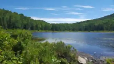
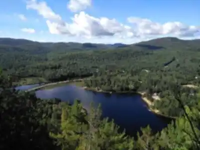
Parc Régional de la Forêt Ouareau is one of Lanaudière's most rewarding natural destinations — a sprawling forested park that gives hikers, paddlers, and outdoor lovers a genuine escape into Quebec's wild interior. Covering over 150 square kilometres, the park offers a trail network that totals approximately 119.8 km, making it one of the more extensive regional parks in the province for on-foot exploration.
The Terrain
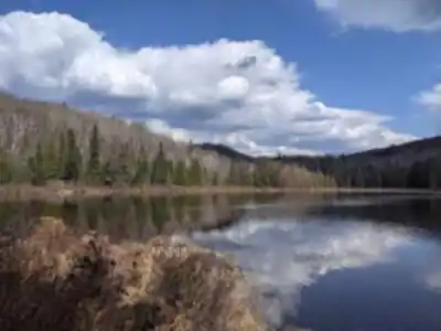
The landscape here is classic Laurentian Shield — rolling forested hills, rocky outcrops, and dense mixed woodland that shifts character as you move through it. The trails wind through stands of maple, birch, and conifer, with the canopy opening up at key viewpoints to reveal wide panoramas of the surrounding hills and valleys. The elevation gain across the network reaches up to 400 m, which keeps things interesting without being punishing. Most of the trails are rated easy, so the park is genuinely accessible to a wide range of hikers, including families and those newer to the sport.
That said, "easy" here doesn't mean flat or featureless. The terrain has enough variation to keep you engaged — rooted paths through shaded forest, open ridgelines with long views, and sections that follow the natural contours of the land rather than cutting straight lines through it. It's the kind of hiking where you're moving through the environment rather than just across it.
What to Expect on the Trail
With nearly 120 km of trails to work with, you have real flexibility in how you structure your visit. A full exploration of the network would take around 30 hours of hiking time, so most visitors will pick a section or loop that fits their day. The trail system is designed to accommodate different paces and goals — whether you're out for a few hours or planning a multi-day outing with an overnight stay.
The forested sections provide good shade in summer, and the mixed tree cover means the park transitions beautifully through the seasons. Fall is particularly striking in this part of Lanaudière, when the hardwoods turn and the ridgeline views take on a completely different quality. Winter brings its own appeal — the park supports snowshoeing when conditions allow, extending its usefulness well beyond the warmer months.
Beyond Hiking
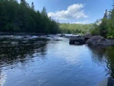
The park isn't exclusively a hiking destination. The waterways within and around the Forêt Ouareau support canoeing and fishing, giving paddlers a reason to visit alongside hikers. This multi-activity setup makes it a practical choice for groups with mixed interests — one person's trail day can pair naturally with another's time on the water.
For those who want to slow things down, the park has picnic areas set up for a proper break in the middle of the day. Campsites are also available for anyone who wants to extend their stay and spend a night under the forest canopy rather than driving back the same evening.
Practical Information
- Total trail distance: 119.8 km of trails across the network
- Elevation gain: Up to 400 m
- Difficulty: Easy (overall network rating)
- Estimated hiking time: Approximately 30 hours for the full network
- Park size: Over 150 square kilometres
- Region: Lanaudière, Quebec
- Activities: Hiking, canoeing, fishing, snowshoeing
- Facilities: Picnic areas, campsites
Parc Régional de la Forêt Ouareau is the kind of place that rewards repeat visits — there's enough trail distance and enough variety in the landscape that you won't cover it all in a single outing, and the park holds up well across different seasons and different levels of ambition.
Services and amenities
This information may vary by season.
Recommended gear for this trail


Ready to go?
Everything you need to know before you goStarting Point
● Grande-Vallée sector :
From Highway 25, continue on Route 125 north to Chertsey. Take Chemin de l'Église, then Chemin de la Grande-Vallée, and finally Rue des Pâquerettes where the parking lot is located.
● Secteur du Massif :
From Notre-Dame-de-la-Merci, you must take route 125 south and then turn left on Chemin du Canard-Blanc. The reception is 800 m further on.
When?
How much?
- Hiking shoes Essential
- → Salomon Elixir Tour Mid WP · 203.38 $
- Layered clothing Essential
- Rain jacket Essential
- Trekking poles
- → Black Diamond Trail Ergo Cork · 69.99 $
- Headlamp
- → Petzl Actik Core 625 · 103.95 $
FAQ - Frequently asked questions
Everything you need to knowThe Essential Hiking Checklist
Everything you need for your next hike. Bilingual, printable, 1 page.
Download the free checklistSimilar hikes nearby
Discover other trails you might enjoy

Mont Sourire
Lanaudière

Parc Des Chutes Dorwin
Lanaudière

Parc des Cascades
Lanaudière

Mont Ouareau
Lanaudière

La Montagne Noire
Lanaudière

Abbaye Val Notre-Dame
Lanaudière
Hiking near Laval
97 trails to explore ~73 km away
We work hard to provide the most up-to-date and error-free data possible. If something seems incorrect, let us know! Your contribution helps the whole community.
Hikers' opinions