


Ready to explore Parc régional de la Chute-à-Bull? Here's everything you need to know before you go!
Discover the trail


Trail description
Chute A Bull is a natural waterfall destination tucked into Québec’s Lanaudière region, and it’s the kind of spot that works whether you’re planning a straightforward hike, a quiet nature walk, or a full day outside with family or friends. The main draw is the falls themselves—rushing water dropping over rocky cliffs—but the approach is just as much part of the experience, with forest trails, viewpoints, and plenty of small details to notice as you go.
What the hike feels like
The trails at Chute A Bull are described as well-maintained, and that’s a big part of what makes the outing approachable for a wide range of visitors. You’re moving through lush forest, where the air tends to feel cooler and more sheltered, and where the scenery changes subtly as you follow the path—dense stands of trees, pockets of open views, and the gradual shift in sound as you get closer to the water.
Along the way, expect a classic forest-hike atmosphere: the scent of pine is part of the experience here, and the sounds of nature are a constant backdrop. Even if you’re not hiking for speed or distance, the trails give you a reason to slow down and take it in—listening for birds, noticing how the light comes through the canopy, and catching occasional views of the surrounding landscape when the trail opens up.
Because the routes are clearly marked, it’s an easy place to focus on the outing itself—walking, looking around, taking photos—without spending the day second-guessing whether you’re still on track.
The waterfall: the main event
The centerpiece of the area is the Chute A Bull waterfall, where water cascades down rocky cliffs in a way that’s hard to ignore once you’re within earshot. The sound builds as you approach, and the final view is a strong payoff: fast-moving water, rugged rock, and that constant misty, energetic feeling you get near a decent set of falls.
This is also the spot that tends to anchor your visit. Some people will come primarily for the waterfall viewpoint and spend their time photographing it; others will treat it as a highlight along a longer wander through the forest. Either way, it’s the kind of landmark that’s easy to appreciate in every season and at every pace—whether you’re taking a quick look or staying longer to watch the flow and take in the setting.
Seasonal feel (and what changes)
Chute A Bull is described as captivating year-round, and it’s easy to see why: the waterfall keeps its visual impact no matter the season, but the mood around it shifts noticeably depending on when you go.
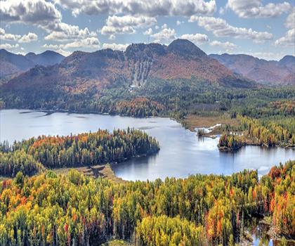
- Fall: The area is especially photogenic when the forest turns and you get those vibrant fall colors framing the water and rock.
- Winter: The landscape becomes quieter and more muted under snow-covered winter conditions, giving the falls a more serene, high-contrast backdrop.
No matter the time of year, the waterfall makes a strong focal point for photos, and the surrounding forest keeps the walk feeling immersive rather than exposed.
Nature watching: wildlife and plants
If you like adding a bit of wildlife watching to your hike, this is a good place to keep your eyes up and your pace relaxed. Visitors may spot local animals along the trails, including curious squirrels and graceful deer. The forest setting also means it’s worth pausing occasionally—wildlife tends to reveal itself when you’re quieter and not rushing.
On the plant side, the area is noted for its diverse flora. As you move through the woods, you’ll see wildflowers in season and plenty of towering trees lining the trails. Even if you’re not a dedicated plant enthusiast, the variety adds texture to the walk—different leaf shapes, understory plants close to the trail, and the way the forest changes from one section to the next.
Trail experience for different groups
Chute A Bull is presented as an outing that can suit all skill levels, which makes it flexible for planning. If you’re newer to hiking, the combination of maintained trails and clear markings helps keep things straightforward. If you have more experience, you can still enjoy it as a scenic, nature-forward hike where the waterfall is a satisfying destination and the forest views make the approach feel worthwhile.
It also works well as a day trip with friends and family. The experience isn’t just about reaching a destination; it’s about spending time outside together—walking, stopping at viewpoints, and settling in for a break when you feel like it.
What to bring
To keep the day comfortable, plan your gear around walking on forest trails and spending time near the falls. The basics recommended for Chute A Bull are exactly what most people will appreciate here:
- Comfortable hiking shoes for the trails
- A camera to capture the waterfall and forest scenery
- A picnic if you want to turn the outing into a longer, more relaxed visit
The emphasis is on being able to move comfortably and enjoy the setting—especially if you’re planning to linger at viewpoints or spend time listening to the water and exploring at an easy pace.
On-site breaks and navigation
One practical detail that makes planning easier is that there are designated rest areas, which pair nicely with the idea of bringing a picnic. These are useful whether you’re hiking with kids, taking a slower nature walk, or simply want a place to stop and enjoy the forest without feeling like you’re blocking the trail.
The trails are also described as clearly marked, which helps the visit feel safe and enjoyable for a wide mix of visitors. Clear signage means less time checking your phone or second-guessing turns, and more time paying attention to the surroundings—especially helpful if you’re visiting for the first time or hiking in a group where people naturally spread out a bit.
The Essential Hiking Checklist
Everything you need for your next hike. Bilingual, printable, 1 page.
Get your free hiking checklistRecommended gear for this trail
As an Amazon Associate I earn from qualifying purchases.


Ready to go?
Everything you need to know before you goStarting Point
To get to the trails of the Chute-à-Bull Regional Park, you must go to Saint-Donat. From there, take Route 158 East and head towards the village of Saint-Zénon. After passing through the village, turn left onto Route 323 South and head towards the Chute-à-Bull Regional Park.
When?
How much?
As an Amazon Associate I earn from qualifying purchases.
Affiliate links — LGPO may earn a commission at no extra cost to you.
- Hiking shoes Essential
- → Salomon Elixir Tour Mid WP · 203.38 $
- Layered clothing Essential
- Rain jacket Essential
- Trekking poles
- → Black Diamond Trail Ergo Cork · 69.99 $
- Headlamp
- → Petzl Actik Core 625 · 103.95 $
FAQ - Frequently asked questions
Everything you need to knowSimilar hikes nearby
Discover other trails you might enjoy

Mont Sourire
Lanaudière

Parc régional de la Forêt Ouareau
Lanaudière

Parc des Chutes Dorwin
Lanaudière

Parc des Cascades
Lanaudière

La Montagne Noire
Lanaudière
Mont Ouareau
Lanaudière
Hiking near Laval
97 trails to explore ~78 km away
We work hard to provide the most up-to-date and error-free data possible. If something seems incorrect, let us know! Your contribution helps the whole community.
Hikers' opinions
Be the first to review!
No hiker has shared their experience yet. Share your impressions and help other hikers!