

Ready to explore Mont Sourire? Here's everything you need to know before you go!
Discover the trail


Trail description
Description
Mont Sourire is a quiet hiking spot tucked into the Lanaudière region, the kind of place you head to when you want a straightforward day outside without a lot of fuss. It's described as a hidden gem, and it fits that role well: you're in the woods, on clearly defined routes, and within a short drive you can trade everyday noise for forest air and open viewpoints.
The hiking experience
Mont Sourire offers a network of trails meant to work for a range of hikers, from people easing into hiking to those who spend a lot of weekends on the trail. The routes are described as well-marked and maintained, which makes it easier to focus on the walk itself instead of constantly double-checking where you are. On a practical level, that also means this is a good choice when you're hiking with mixed experience levels and want something that feels manageable.
The main trail covers about 2 kilometers with a steady 300-meter climb that takes most people around an hour and fifteen minutes to complete. It's rated as easy, which doesn't mean effortless—you're still gaining elevation—but the grade is consistent and the footing is reliable. As you climb, the experience is very much "Lanaudière outdoors": forested sections with changing light through the trees, a steady sense of gaining height, and the anticipation of reaching a viewpoint.
The terrain underfoot shifts as you ascend. You start in dense forest where the canopy filters the light into shifting patterns on the trail. The path is wide enough that you don't have to worry about branches catching your pack, but narrow enough that it feels like you're moving through the woods rather than on a highway. As you gain elevation, the forest opens up gradually, giving you glimpses of what's coming at the summit.
Views from the summit
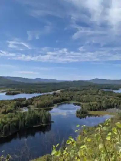
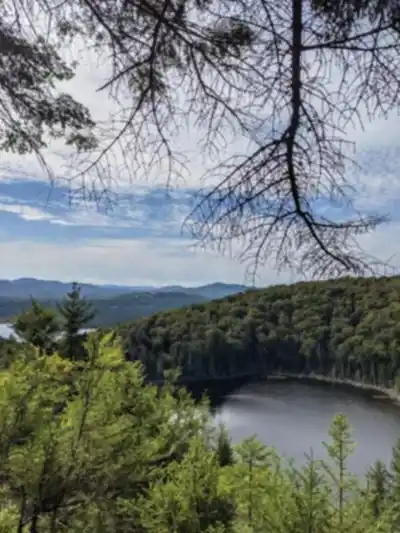
The main payoff at Mont Sourire is at the top. As you ascend, you're working toward panoramic views of the surrounding landscape, and the summit is described as a true vantage point over the region. From there, you can take in the rolling hills and the broad stretches of lush forest that define this part of Lanaudière. You'll also see sparkling lakes in the distance, which adds a nice contrast to the green canopy and gives the view a "big map" feel—like you can trace the landscape with your eyes.
If you're the type who likes to pause and actually enjoy the top instead of tagging it and turning around immediately, plan to linger a bit. The summit viewpoint is the kind of place where it's worth taking your pack off, having a snack, and letting the effort of the climb settle in. There's enough space for a small group to spread out without crowding each other, and the view changes subtly as you move around the summit area.
Wildlife and natural features
Mont Sourire is also a good pick if you like the naturalist side of hiking. The area is home to a mix of flora and fauna, and it's the kind of trail where you can keep your eyes moving between the forest floor, the understory, and the treetops. Deer and foxes are listed among the native wildlife you might spot, along with a variety of bird species—so it's worth slowing down now and then and listening for movement or calls.
On the plant side, expect vibrant wildflowers in season and tall trees that give the hike a sheltered, "in the woods" feel for much of the climb. The forest composition changes subtly as you gain elevation, with different species dominating at different heights. Those details are part of what makes the mountain feel like a natural haven rather than just a quick workout trail.
The best wildlife viewing happens early in the morning or later in the afternoon when animals are more active. If you're quiet and observant, you might catch sight of movement in your peripheral vision or hear the rustle of something moving through the underbrush just off the trail.
Seasonal variations
Mont Sourire isn't limited to summer hiking. It's described as a year-round destination, which is useful if you're looking for a reliable place to get outside no matter the month. Each season brings its own character to the same basic route.
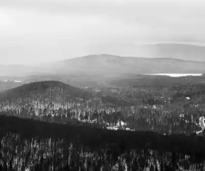
Winter transforms the trails into a winter playground for snowshoeing and cross-country skiing, with the landscape shifting into a quieter, snow-covered version of the same route. The views from the summit take on a stark beauty when the lakes are frozen and the forest is draped in snow.
Spring brings blooming flowers and fresh greenery as the forest wakes up, which can make familiar sections of trail feel brand new. This is when you'll see the most dramatic wildflower displays, and the sound of snowmelt and early season streams adds a soundtrack to your hike.
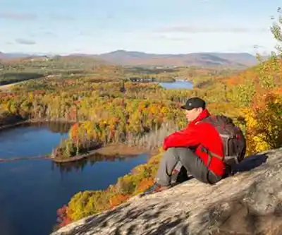
Autumn might be the most spectacular season here. The mountain and surrounding hillsides take on rich reds and golds, making the climb especially scenic as the leaves change. The summit views become more expansive as the canopy thins out, revealing distant features that are hidden during the full-leaf months.
Getting there and practical details
Mont Sourire is conveniently located within Lanaudière and is described as easily accessible by car. There's ample parking available at the trailhead, which helps keep the start of your hike simple: arrive, gear up, and go without worrying about hunting for a spot. The parking area is well-maintained and provides a clear starting point for the trail system.
For what to bring, the essentials matter here the same way they do on any mountain trail. Pack plenty of water and some snacks, and choose appropriate gear for the conditions—especially if you're visiting outside the summer season when traction, warmth, or extra layers can make the day much more comfortable. Even though the hike is rated as easy, you're still gaining significant elevation, so treat it like a proper outing rather than a casual stroll.
Trail etiquette is also part of the experience at Mont Sourire. The guidance here is clear: stay on marked paths and leave no trace. Sticking to the marked trail protects the plants and reduces erosion, and leaving no trace keeps the area feeling wild and welcoming for the next group that comes through.
Who should hike here
This is the kind of hike that works well whether you're looking for quiet time outdoors or a simple plan with friends. Because the trails cater to different levels and are well-marked and maintained, it can fit a lot of group dynamics—people who want to push the pace can move steadily uphill, while others can take it slower and still enjoy the same destination.
The easy rating and moderate distance make it accessible to families with older kids who are ready for their first real mountain hike, while the summit views and wildlife viewing opportunities keep it interesting for more experienced hikers. If your ideal day includes a solid climb, a rewarding viewpoint over Lanaudière's hills, forests, and lakes, and a trail where you can keep an eye out for deer, foxes, and birds along the way, Mont Sourire delivers that kind of experience in a straightforward, practical package.
Services and amenities
This information may vary by season.
Recommended gear for this trail


Ready to go?
Everything you need to know before you goStarting Point
To access the hiking trails, you can start at the main trailhead located at 1234 Chemin des Randonnées, Sainte-Émélie-de-l'Énergie, QC. There is a parking lot available at this location. Additionally, there is an alternative trailhead with parking at 5678 Route de la Montagne, Saint-Côme, QC. Both locations provide access to the network of trails in the area.
When?
How much?
- Hiking shoes Essential
- → Salomon Elixir Tour Mid WP · 203.38 $
- Layered clothing Essential
- Rain jacket Essential
- Trekking poles
- → Black Diamond Trail Ergo Cork · 69.99 $
- Headlamp
- → Petzl Actik Core 625 · 103.95 $
FAQ - Frequently asked questions
Everything you need to knowThe Essential Hiking Checklist
Everything you need for your next hike. Bilingual, printable, 1 page.
Download the free checklistSimilar hikes nearby
Discover other trails you might enjoy

Parc Régional De La Forêt Ouareau
Lanaudière

Parc Des Chutes Dorwin
Lanaudière

Parc des Cascades
Lanaudière

La Montagne Noire
Lanaudière

Mont Ouareau
Lanaudière

Abbaye Val Notre-Dame
Lanaudière
Hiking near Laval
97 trails to explore ~85 km away
We work hard to provide the most up-to-date and error-free data possible. If something seems incorrect, let us know! Your contribution helps the whole community.
Hikers' opinions