

Ready to explore Bruce Trail? Here's everything you need to know before you go!
Discover the trail


Trail description
Description
The Bruce Trail is Ontario's premier long-distance hiking route, stretching 885 kilometers (550 miles) from Niagara Falls in the south to the windswept shores of Tobermory on the Bruce Peninsula in the north. Supplemented by hundreds of additional kilometers of side trails, it follows the ancient limestone spine of the Niagara Escarpment through some of the most varied and rewarding landscapes in southern and central Ontario. For hikers in the Hamilton, Halton and Brant region, this section of the trail offers a compelling mix of dramatic escarpment scenery, dense forest, and accessible day-hiking options right at the doorstep of the Greater Golden Horseshoe.
The Terrain
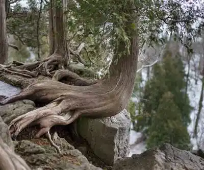
What sets the Bruce Trail apart from most hiking routes in Ontario is the sheer diversity of what you walk through. The Niagara Escarpment itself is a UNESCO World Biosphere Reserve, and the trail makes full use of that designation. You'll move between cliff edges with sweeping views over Lake Ontario, old-growth hardwood forests where the canopy closes overhead like a cathedral, open meadows, wetland boardwalks, and fossil-rich limestone outcroppings that tell a geological story hundreds of millions of years in the making.
In the Hamilton and Halton sections specifically, the escarpment face is particularly dramatic. The trail hugs cliff edges, dips into wooded ravines, and passes near several waterfalls — Hamilton is famously home to more waterfalls than any other city in the world, and the Bruce Trail connects many of them. Elevation gain in certain sections reaches 430 meters, which means some stretches deliver a genuine workout with steep climbs requiring careful footing and a reasonable level of fitness.
Trail Markings and Navigation
Navigation on the Bruce Trail is straightforward once you understand the system. The main trail is marked with white blazes — painted white rectangles on trees, rocks, and posts — at regular intervals. Side trails branch off and are marked with blue blazes, offering shorter loops, alternate routes, or access to specific viewpoints and features. The system is consistent across the entire trail's length, which makes it easy to pick up even if you're hiking a section for the first time.
That said, some sections in more remote or heavily wooded areas require closer attention to the blazes, particularly after storms when fallen trees can obscure markers. The Bruce Trail Conservancy publishes detailed maps and guidebooks broken down by section, which are worth having on hand for anything beyond a well-known day hike.
History of the Trail
The Bruce Trail has its roots in a 1959 proposal by the Halton-Hamilton Hiking Club, whose members envisioned a continuous footpath running the full length of the Niagara Escarpment. It was an ambitious idea at the time — much of the land was privately owned, and creating a public trail across it required negotiating access with hundreds of individual landowners. Through volunteer effort, community cooperation, and the goodwill of those landowners, the trail officially opened on May 24, 1960.
Today, the Bruce Trail Conservancy manages and maintains the route, continuing to work on land acquisition and stewardship to protect the escarpment corridor for future generations. A significant portion of the trail still crosses private land, and hikers are expected to stay on the marked route and respect the access that landowners generously provide.
Hiking the Hamilton and Halton Section
This section of the Bruce Trail is one of the most accessible and heavily used stretches of the entire route, which is both a strength and something to be aware of. On weekends, popular access points near Hamilton and the Halton Hills can be busy, particularly in fall when the escarpment colors are at their peak. If you prefer a quieter experience, weekday mornings or early spring visits tend to offer more solitude.
The trail here works well as a series of day hikes rather than a continuous thru-hike. Numerous trailheads, conservation area parking lots, and road crossings make it easy to plan out-and-back routes or point-to-point hikes with a car shuttle. Estimated hiking time for a typical section in this area runs around 1 hour 30 minutes, though that varies considerably depending on which stretch you choose and how much time you spend at viewpoints.
Wildlife is a regular part of the experience. White-tailed deer are common, wild turkeys appear frequently in open areas, and the diverse ecosystems along the escarpment support a wide range of bird species. The forest understory in spring is particularly rewarding for wildflower enthusiasts, with trilliums, trout lilies, and various native orchids appearing in season.
Seasonal Conditions
The Bruce Trail is open year-round, but conditions vary significantly by season. Spring brings muddy sections and high water at stream crossings, along with the best wildflower displays. Summer is prime hiking season — long days, full canopy shade on forested sections, and reliable trail conditions. Fall is arguably the most popular time, with the escarpment's hardwood forests turning brilliant shades of orange, red, and yellow.
Winter hiking is possible but requires preparation. The trail receives no winter maintenance, and cliff-edge sections and steep descents can become icy and genuinely hazardous. Microspikes or crampons are strongly recommended from December through March. For those willing to gear up appropriately, winter offers a quieter trail and some striking scenery, including frozen waterfalls along the escarpment face.
Practical Notes
- Trail markings: White blazes for the main trail, blue blazes for side trails.
- Maps and guides: Available through the Bruce Trail Conservancy, broken down by section.
- Access: Multiple trailheads throughout the Hamilton and Halton region with parking at conservation areas and designated lots.
- Land stewardship: Much of the trail crosses private land — stay on the marked route and leave no trace.
- Winter conditions: No maintenance from December through March; traction devices recommended on icy sections.
Whether you're looking for a challenging half-day hike along the escarpment edge or a gentle walk through Carolinian forest, the Bruce Trail in the Hamilton, Halton and Brant region delivers some of the most rewarding hiking in Ontario.
Recommended gear for this trail


Ready to go?
Everything you need to know before you goStarting Point
To access the hiking trails, you can start at several trailheads in the area. Here are some options:
Dundas Valley Conservation Area: You can park at 650 Governors Road, Dundas, ON L9H 5E3. This location provides access to multiple trailheads within the conservation area.
Royal Botanical Gardens (RBG): The RBG offers parking and trail access at 680 Plains Road West, Burlington, ON L7T 4H4. From here, you can explore various sections of the trails.
Kelso Conservation Area: Located at 5234 Kelso Road, Milton, ON L9T 2X7, this area offers parking and entry points to the trails.
Mount Nemo Conservation Area: You can find parking and trail access at 5317 Guelph Line, Burlington, ON L7P 0A5.
These locations provide convenient starting points for exploring the extensive network of trails in the region.
When?
How much?
- Hiking shoes Essential
- → Salomon Elixir Tour Mid WP · 203.38 $
- Layered clothing Essential
- Rain jacket Essential
- Trekking poles
- → Black Diamond Trail Ergo Cork · 69.99 $
- Headlamp
- → Petzl Actik Core 625 · 103.95 $
FAQ - Frequently asked questions
Everything you need to knowThe Essential Hiking Checklist
Everything you need for your next hike. Bilingual, printable, 1 page.
Download the free checklistSimilar hikes nearby
Discover other trails you might enjoy

Nassagaweya Canyon
Hamilton, Halton and Brant
Dundas Valley Conservation Area
Hamilton, Halton and Brant
Crawford Lake Conservation Area (Reservations Required)
Hamilton, Halton and Brant
Royal Botanical Gardens - Hendrie Valley Sanctuary (Cherry Hill Gate Trail)
Hamilton, Halton and Brant
Paletta Lakefront Park
Hamilton, Halton and Brant
Rattlesnake Point Conservation Area (Reservations Required)
Hamilton, Halton and Brant
Hiking near Guelph
166 trails to explore ~24 km away
We work hard to provide the most up-to-date and error-free data possible. If something seems incorrect, let us know! Your contribution helps the whole community.
Hikers' opinions