

Ready to explore Mont Chocolat? Here's everything you need to know before you go!
Discover the trail


Trail description
Description
Mont Chocolat is a quietly rewarding hiking destination tucked into the Parc régional des Appalaches in the Chaudière-Appalaches region of Quebec. It's the kind of place that doesn't try too hard to impress you—it just delivers a solid day in the forest, with enough elevation gain to make the views feel earned and enough trail variety to suit a wide range of hikers. Whether you're new to hiking or simply looking for a relaxed outing between bigger objectives, this is a dependable choice.
What the hike feels like
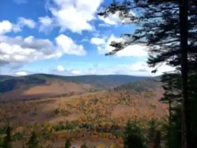
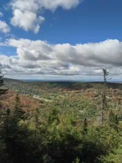
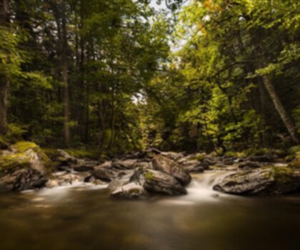
The experience at Mont Chocolat is built around time in the forest. For most of the hike, you're moving through tree cover—shaded, earthy, and genuinely immersive. The canopy keeps things cooler on warm days, and the understory is lush enough that there's always something to look at close up: ferns, mosses, the textures of bark and rock. As you gain elevation, the character of the trail shifts. The forest opens up gradually, clearings appear more often, and eventually the terrain lifts enough to give you broad views over the rolling hills and dense woodlands that define this part of Quebec.
With a 756 m elevation gain and an estimated hiking time of around 3 hours 15 minutes, the effort level is real but manageable. The trail is rated Easy, which reflects the quality of the markings and the overall accessibility of the route rather than a completely flat profile. You'll feel the climb, but it's steady and well-paced rather than technical or demanding.
Trails and navigation
Mont Chocolat offers a variety of trails suited to different skill levels, which makes it a practical option if you're planning a day with mixed abilities in the group. The trails are well-marked and maintained, so you can stay focused on your pace and the scenery rather than constantly checking your position. That said, it's worth treating this like any forest mountain outing: review your route before you start, keep a general sense of where you are on the mountain, and be ready for conditions to shift as you move through different sections of the trail network.
The variety in the trail system also gives you flexibility on the day. If energy is high and conditions are good, you can push further. If someone in the group needs a shorter loop, the options are there without having to backtrack awkwardly.
Views and photo spots
The payoff for the climb is the sense of space you get at the higher sections of the trail. The surrounding landscape opens into the classic Chaudière-Appalaches look—rolling hills and dense forests stretching outward in every direction. On clear days, the views carry well across the region, and the ridgelines in the distance give you a real sense of the scale of this part of Quebec's Appalachian foothills.
If you're hiking with a camera, plan a bit of extra time at the open sections. Light changes quickly depending on cloud cover, and even a short pause at a viewpoint can turn into one of the better moments of the day. The viewpoints aren't crowded or heavily developed—they feel like natural pauses in the trail rather than designated tourist stops, which suits the overall tone of the hike.
Wildlife and nature highlights
The area around Mont Chocolat is known for its rich biodiversity, and that shows up throughout the hike. Keep an eye out for deer and foxes, particularly in the quieter sections of the trail where the forest feels more still. Bird activity is consistent through the warmer months, and the edges of clearings are often the most productive spots to pause and listen.
The plant life adds a lot to the experience too. The trails run through lush, varied forest, and the flora changes noticeably as you gain elevation. Fall is a particularly striking time to visit—the leaves shift into vibrant reds and golds, familiar sections of trail look completely different, and the more open feel of the woods as the season progresses makes the views even wider. It's one of those hikes that genuinely rewards a return visit in a different season.
Planning your day
Before heading out, check local weather and trail conditions. Forested mountain terrain in this region can shift quickly—temperature drops, wind at the viewpoints, and the possibility of rain are all worth factoring into what you wear and carry. Layering is the practical approach: something that works in the shaded lower sections and still keeps you comfortable during longer stops at exposed viewpoints.
Pack the basics for a day hike: water, snacks, and clothing layers. If you're hiking with newer hikers or kids, snacks and water matter more than usual—a simple food break mid-hike can reset energy and keep the pace feeling smooth rather than grinding. The estimated 3h15 duration is a reasonable planning target, though your actual time will depend on how often you stop and how much time you spend at the viewpoints.
Trail etiquette and Leave No Trace
The calm, natural feel of Mont Chocolat is worth protecting. Follow Leave No Trace principles throughout your visit: stay on designated trails, carry out everything you bring in, and avoid cutting switchbacks or stepping off-trail to pass other hikers. Staying on the marked path also reduces erosion on the steeper sections and protects the vegetation along the trail edges—small habits that add up over time when a lot of people are using the same routes.
Extending your day in Chaudière-Appalaches
One of the practical advantages of hiking Mont Chocolat is that you're already in a part of Quebec that's easy to build a full day around. The Chaudière-Appalaches region is rich in culture and history, and the area around the park includes charming villages, opportunities to try local cuisine, and low-key exploring that pairs naturally with a morning or afternoon on the trails—without requiring a complicated itinerary to pull it together.
Services and amenities
This information may vary by season.
Recommended gear for this trail


Ready to go?
Everything you need to know before you goStarting Point
To access the hiking trails, head to the main trailhead located at Sentier des Caps de Charlevoix. The parking lot for this trailhead is situated at 2 Rue Leclerc, Saint-Tite-des-Caps, QC G0A 4J0. There are no alternative trailheads for this location.
When?
How much?
- Hiking shoes Essential
- → Salomon Elixir Tour Mid WP · 203.38 $
- Layered clothing Essential
- Rain jacket Essential
- Trekking poles
- → Black Diamond Trail Ergo Cork · 69.99 $
- Headlamp
- → Petzl Actik Core 625 · 103.95 $
FAQ - Frequently asked questions
Everything you need to knowThe Essential Hiking Checklist
Everything you need for your next hike. Bilingual, printable, 1 page.
Download the free checklistSimilar hikes nearby
Discover other trails you might enjoy

Auberge des Glacis
Chaudière-Appalaches
Parc régional du Massif du Sud
Chaudière-Appalaches
Parc Des Chutes-de-la-chaudière
Chaudière-Appalaches

Domaine Joly-De Lotbinière
Chaudière-Appalaches

Domaine du Radar
Chaudière-Appalaches

Mont Orignal
Chaudière-Appalaches
Hiking near Quebec City
40 trails to explore ~61 km away
We work hard to provide the most up-to-date and error-free data possible. If something seems incorrect, let us know! Your contribution helps the whole community.
Hikers' opinions