

Ready to explore Parc National De La Pointe-taillon? Here's everything you need to know before you go!
Discover the trail

Available trails
| Trails | Distance | Elevation | Duration | Difficulty | GPX |
|---|---|---|---|---|---|
| 20 km | 0 m | 4h30 | Beginner | ||
| 44 km | 0 m | 10h | Beginner | ||
| 38 km | 0 m | 8h30 | Beginner | ||
| 12 km | 0 m | 3h | Beginner | ||
| 16 km | 0 m | 3h30 | Beginner |
Trail description
Description
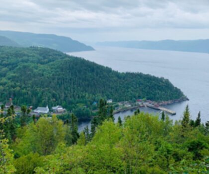
Parc National De La Pointe-Taillon is a quiet, nature-forward destination in the Saguenay - Lac-Saint-Jean region, set where forest meets the wide, calm shoreline of Lac Saint-Jean. It’s the kind of park that works for many styles of outings in one place: unhurried hikes, wildlife watching, beach time, paddling, and even cycling if you want to cover more ground. The overall feel is accessible and relaxed, with well-maintained paths that let you focus on the scenery instead of your footing.
What the hiking experience is like
The park has an extensive network of trails designed to suit a range of comfort levels. You can keep it simple with an easy walk or string together longer sections for a more ambitious day out. The trail system is known for being well maintained, which makes it a good choice if you want a low-stress outing where you’re not constantly picking your way through rough terrain.
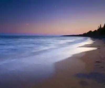
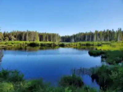
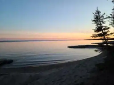
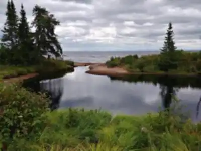
As you hike, expect a mix of environments rather than a single type of landscape. Trails meander through lush forest and then open up along the shores of Lac Saint-Jean, where the mood changes completely—more open sky, more wind off the water, and long views that make frequent pauses feel natural. Because the routes run near the lake, you’ll often get that “two-in-one” experience: sheltered forest walking followed by breezy shoreline sections with scenery in every direction.
If you’re planning a route that includes both forest and lakeside segments, pack with small transitions in mind. Layers are helpful for moving between shaded trees and exposed shoreline, and it’s worth bringing a camera even on a short outing—the views along the lake have a way of showing up when you least expect them.
Distance, elevation, and difficulty
The Parc National De La Pointe-taillon trail listing is 45 km with an elevation gain of 10 m, and it’s rated Easy. In practice, that combination points to mostly flat terrain and a comfortable pace for a lot of hikers, including those who want to prioritize scenery, wildlife spotting, or time by the water over steep climbs.
Scenery and terrain highlights
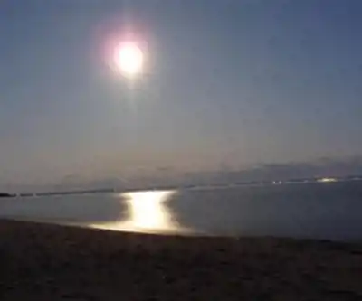
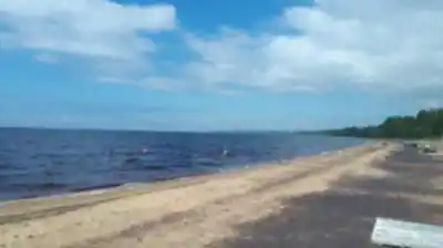
What stands out here is how consistently the park delivers “nice moments” along the way. In the forest, you’re surrounded by greenery and that calm, enclosed feeling you get under a full canopy. Along the lake, the landscape becomes more expansive and open. The shoreline sections are especially rewarding if you like wide-water views and the sense of space you don’t always get on inland trails.
The park’s sandy beaches add a different texture to the day. Even if you came primarily for hiking, it’s easy to end up taking a longer break than planned—sitting down for a snack, stretching out, or simply watching the lake. These beach areas naturally work as rest stops, picnic spots, or a simple “turnaround point” if you’re planning an out-and-back walk.
Wildlife and nature viewing
Parc National De La Pointe-Taillon is a strong choice if you like spotting wildlife while you hike. The park is home to diverse wildlife and plant species, and you can watch for moose, beavers, and a variety of bird species as you move along the trails. The mix of forest and shoreline environments creates good variety for wildlife observation, and the slower pace of easier terrain can make it simpler to notice movement, tracks, or birdsong.
If photography is part of your plan, the setting offers a lot without requiring technical hiking. You can take your time with nature details in the forest, then switch to wider landscape shots along Lac Saint-Jean. Patience helps—wildlife moments are rarely on schedule—but the biodiversity here gives you plenty to look for.
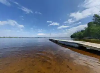
Water activities: paddling, swimming, and beach time
Hiking isn’t the only reason people come here. The park is also known for water activities on Lac Saint-Jean, and the lake is a natural anchor for a full day outdoors. If you want to get on the water, this is a place for kayaking and canoeing, with the lake’s broad surface giving you room to paddle and explore at your own pace.
For warm-weather visits, swimming is also part of the experience. Pairing a hike with a swim can be a great way to balance activity and downtime, especially when your route includes shoreline sections that make it easy to transition from trail to water.
If you prefer staying on land, the sandy beaches are ideal for a low-key afternoon. They work well for picnicking and relaxing, and they’re also a practical option if your group includes people who aren’t hiking much but still want to enjoy the park setting.
Cycling through the park: Véloroute des Bleuets
Cyclists have a standout option here: the Véloroute des Bleuets, a 256-kilometer cycling route that circles Lac Saint-Jean and passes through the park. This route gives you a different way to experience the landscape—covering more distance while still staying connected to the natural scenery that defines the area.
If your visit includes both hiking and cycling, the park makes it easy to build a varied itinerary. You might choose a shorter hike near the shoreline and then spend the rest of the day riding a section of the Véloroute des Bleuets, or do the reverse—ride first, then unwind with a gentle walk and time on the beach.
Camping and how to plan your time
Parc National De La Pointe-Taillon works well as either a day trip or a longer stay. If you want to keep things simple, you can come for a single hike and add a beach break or quick paddle. If you’d rather slow down and experience more of the trail network, there are camping facilities available within the park, which makes it possible to spread your activities over multiple days and enjoy the park’s atmosphere from morning to evening.
For trip planning, it helps to think in “blocks” of time rather than trying to cram everything into one continuous push. The park’s layout and variety lend themselves to a flexible day: hike a section of trail, stop to watch birds along the shore, take a swim, then finish with a picnic on the sand. Because the trails are maintained and the terrain is gentle overall, it’s a comfortable place to adjust plans on the fly based on weather, energy, or what your group feels like doing.
Services and amenities
This information may vary by season.
Recommended gear for this trail


Ready to go?
Everything you need to know before you goStarting Point
To access the hiking trails, head to the main entrance where you'll find the parking lot. The address for this entrance is 835 Rang 3 Ouest, Saint-Henri-de-Taillon, QC G0W 2X0. There are no additional trailheads with separate addresses; all trails can be accessed from this location.
When?
Tuesday: 9:00 AM – 5:00 PM
Wednesday: 9:00 AM – 5:00 PM
Thursday: 9:00 AM – 5:00 PM
Friday: 9:00 AM – 7:00 PM
Saturday: 9:00 AM – 5:00 PM
Sunday: 9:00 AM – 5:00 PM
How much?
- Hiking shoes Essential
- → Salomon Elixir Tour Mid WP · 203.38 $
- Layered clothing Essential
- Rain jacket Essential
- Trekking poles
- → Black Diamond Trail Ergo Cork · 69.99 $
- Headlamp
- → Petzl Actik Core 625 · 103.95 $
FAQ - Frequently asked questions
Everything you need to knowTuesday: 9:00 AM – 5:00 PM
Wednesday: 9:00 AM – 5:00 PM
Thursday: 9:00 AM – 5:00 PM
Friday: 9:00 AM – 7:00 PM
Saturday: 9:00 AM – 5:00 PM
Sunday: 9:00 AM – 5:00 PM
The Essential Hiking Checklist
Everything you need for your next hike. Bilingual, printable, 1 page.
Download the free checklistSimilar hikes nearby
Discover other trails you might enjoy
Parc National Du Fjord-du-saguenay
Saguenay - Lac-Saint-Jean

Parc National Des Monts-valin
Saguenay - Lac-Saint-Jean
Sainte-rose-du-nord
Saguenay - Lac-Saint-Jean

Les Sentiers Du Saguenay
Saguenay - Lac-Saint-Jean

Parc De La Rivière Du Moulin
Saguenay - Lac-Saint-Jean

Parc des Chutes de Montauban
Saguenay - Lac-Saint-Jean
Hiking near Quebec City
40 trails to explore ~213 km away
We work hard to provide the most up-to-date and error-free data possible. If something seems incorrect, let us know! Your contribution helps the whole community.
Hikers' opinions